Delaware Water Gap Toll Bridge Map

Static map a segment of the Delaware Water Gap Toll Bridge

Using The Interactive Toll Map

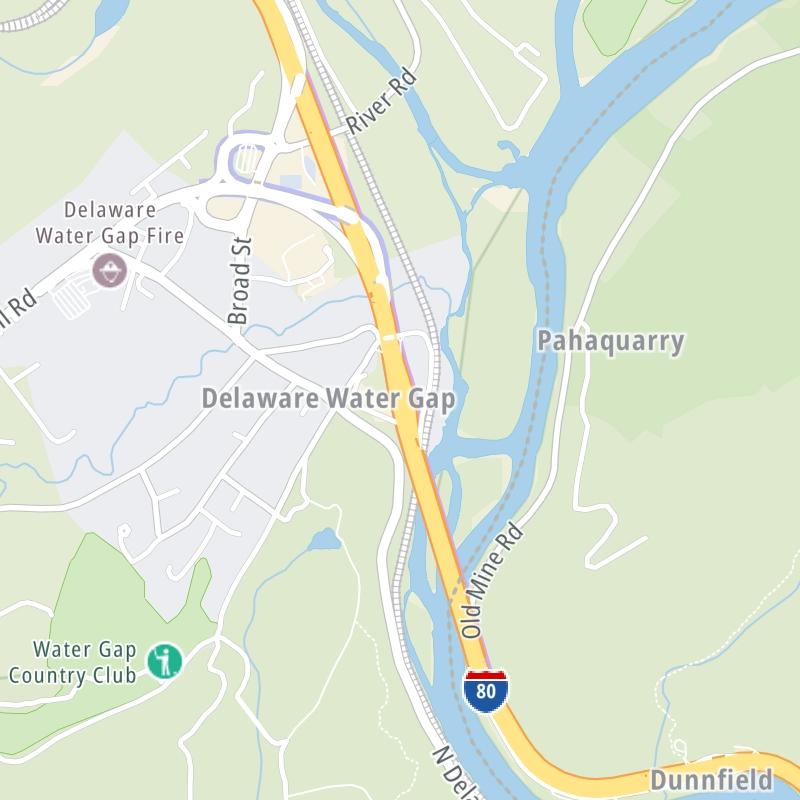
This bridge serves Delaware Water Gap and Hardwick Township. The road map of the Delaware Water Gap Toll Bridge shows exits and tolling points on the road.

A complete list of exits and other points-of-interest may be found below the map.

View Map ▾Exit / POI List ▾

You may pan and zoom the interactive map. There are markers you may select for a separate map of that point of interest or location, which includes any nearby dining, gas, EV charging, hotels and other services.

Advertising
Advertising

The Delaware Water Gap Toll Bridge Toll Map

This map of the Delaware Water Gap Toll Bridge displays markers for exits and tolling points, which you can select to get a close-up map of that point of interest or location.

The points-of-interest shown on this map are also listed below, ordered from west to east.

Advertising
Advertising

List Of Exits / Points Of Interest For The Delaware Water Gap Toll Bridge

Select an exit or other location to get a separate map, including locations of available gas, EV charging, fast-food and other dining options, plus current weather and driving conditions.

Foxtown Hill Road

Exit 310Foxtown Hill Road — Delaware Water Gap

View Map & Info

▸ GPS 40.985790000 X -75.138559000
NOTES: to Broad St / Pennsylvania Welcome Ctr

DRJTBC Delaware River Joint Toll Bridge Commission manages this segment.

Bridge Toll Plaza / Gantry

Bridge Toll Plaza / Gantry — Delaware Water Gap

View Map & Info

▸ GPS 40.983124000 X -75.137776000
NOTES:

DRJTBC Delaware River Joint Toll Bridge Commission manages this segment.

River Road

River Road — Hardwick Township

View Map & Info

▸ GPS 40.971915000 X -75.132695000
NOTES: to Kittatinny Pt Vistor Ctr / Appalachian Trail

DRJTBC Delaware River Joint Toll Bridge Commission manages this segment.

Advertising
Advertising

EXPLORE PENNSYLVANIA

Journey to key destinations around and adjacent to Pennsylvania!

Map Of This Region ▹

Communities in this metro area include Pittsburgh, Cranberry Township, Beaver Valley, New Castle, Washington, Uniontown, Cheat Lake, West Virginia, Boardman, Ohio, and Youngstown, Ohio.

Individual toll maps for this region are listed below.

Map Of This Region ▹

Communities in this metro area include Harrisburg, Mechanicsburg, Carlisle, Hershey, and York.

Individual toll maps for this region are listed below.

Map Of This Region ▹

Communities in this metro area include Philadelphia, King Of Prussia, Valley Forge, West Chester, Bristol, Burlington, New Jersey, Morrisville, Trenton, New Jersey, Palmyra, New Jersey, Wilmington, Delaware, and Camden, New Jersey.

Individual toll maps for this region are listed below.

Map Of This Region ▹

Communities in this metro area include Scranton, Wilkes Barre, Stroudsburg, Clarks Summit, and Knowlton Township, New Jersey.

Individual toll maps for this region are listed below.

Map Of This Region ▹

Communities in this metro area include Camden, Burlington, Palmyra, Pennsauken, Cherry Hill, Gloucester City, Trenton, Wilmington, Delaware, Philadelphia, Pennsylvania, Tacony, Pennsylvania, and Bristol, Pennsylvania.

Individual toll maps for this region are listed below.

Map Of This Region ▹

Communities in this metro area include Knowlton Township, Trenton, Phillipsburg, Easton, Pennsylvania, Lambertville, Ewing, Morrisville, Pennsylvania, and Stroudsburg, Pennsylvania.

Individual toll maps for this region are listed below.

Map Of This Region ▹

Communities in this metro area include Cleveland, Akron, Boardman, Lorain, Aurora, Youngstown, New Castle, Pennsylvania, and Beaver Falls, Pennsylvania.

Individual toll maps for this region are listed below.

Advertising
Advertising