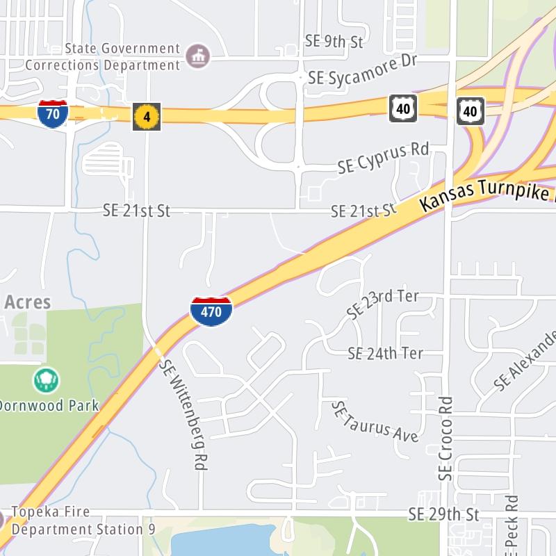
This state toll road serves several key cities, including Emporia, Kansas City, Topeka, Wichita, El Dorado, and Lawrence. The road map of the Kansas Turnpike shows exits and tolling points on the road.
A complete list of exits and other points-of-interest may be found below the map.
You may pan and zoom the interactive map. There are markers you may select for a separate map of that point of interest or location, which includes any nearby dining, gas, EV charging, hotels and other services.
This map of the Kansas Turnpike displays markers for exits and tolling points, which you can select to get a close-up map of that point of interest or location.
The points-of-interest shown on this map are also listed below, ordered from south to north.
Select an exit or other location to get a separate map, including locations of available gas, EV charging, fast-food and other dining options, plus current weather and driving conditions.
Oklahoma State Line — Guelph Township
▸ GPS 36.999056000 X -97.342588000
Kansas Turnpike Authority manages this segment.
Exit 4US 166 / US 81 — Guelph Township
▸ GPS 37.057040000 X -97.338306000
NOTES:
Kansas Turnpike Authority manages this segment.
Southern Terminal Toll Plaza — Wellington
▸ GPS 37.238653000 X -97.338675000
NOTES:
Kansas Turnpike Authority manages this segment.
Exit 19US 160 — Wellington
▸ GPS 37.275978000 X -97.340180000
NOTES:
Kansas Turnpike Authority manages this segment.
Belle Plaine Service Area — Wellington
▸ GPS 37.366567000 X -97.322463000
NOTES:
Exit 33K53 — Peck
▸ GPS 37.471814000 X -97.322719000
NOTES: to US 81
Kansas Turnpike Authority manages this segment.
Exit 39US 81 — Haysville
▸ GPS 37.559304000 X -97.325760000
NOTES:
Kansas Turnpike Authority manages this segment.
Exit 42I–135 / I–235 / 47th Street — Wichita
▸ GPS 37.601473000 X -97.322927000
NOTES:
Kansas Turnpike Authority manages this segment.
Exit 45K15 — Wichita
▸ GPS 37.626343000 X -97.292138000
NOTES:
Kansas Turnpike Authority manages this segment.
Exit 50Kellogg Avenue / US 54 / US 400 — Wichita
▸ GPS 37.675000000 X -97.230370000
NOTES:
Kansas Turnpike Authority manages this segment.
Exit 53K96 — Wichita
▸ GPS 37.686677000 X -97.180684000
NOTES:
Kansas Turnpike Authority manages this segment.
Exit 57E 21st Street / Andover — Andover
▸ GPS 37.720082000 X -97.112070000
NOTES:
Kansas Turnpike Authority manages this segment.
Towanda Service Area — Towanda
▸ GPS 37.766234000 X -96.981262000
NOTES:
Exit 71K254 — El Dorado
▸ GPS 37.819373000 X -96.902711000
NOTES:
Kansas Turnpike Authority manages this segment.
Exit 76US 77 — El Dorado
▸ GPS 37.875849000 X -96.846324000
NOTES:
Kansas Turnpike Authority manages this segment.
Exit 92K177 — Cassoday
▸ GPS 38.051071000 X -96.634203000
NOTES:
Kansas Turnpike Authority manages this segment.
Matfield Green Service Area — Cassoday
▸ GPS 38.095150000 X -96.579524000
NOTES:
Exit 127Begin I–335 / I–35 North / US 50 — Emporia
▸ GPS 38.414812000 X -96.237608000
NOTES:
Kansas Turnpike Authority manages this segment.
Emporia Service Area — Emporia
▸ GPS 38.471513000 X -96.184408000
NOTES:
Exit 147US 56 — Reading
▸ GPS 38.648563000 X -96.030516000
NOTES:
Kansas Turnpike Authority manages this segment.
Exit 177End I–335 / I–470 West — Topeka
▸ GPS 38.991425000 X -95.692500000
NOTES: to US 75
Kansas Turnpike Authority manages this segment.
Exit 182I–70 West / US 40 / K4 — Tecumseh
▸ GPS 39.026442000 X -95.624452000
NOTES: SB On/NB Off
Kansas Turnpike Authority manages this segment.
Exit 183I–70 West / US 40 / K4 — Tecumseh
▸ GPS 39.031703000 X -95.584781000
NOTES: SB Off/NB On
Kansas Turnpike Authority manages this segment.
Topeka Service Area — Tecumseh
▸ GPS 39.019532000 X -95.508481000
NOTES:
Exit 197K10 — Lawrence
▸ GPS 38.996528000 X -95.343939000
NOTES:
Kansas Turnpike Authority manages this segment.
Exit 202US 59 South — Lawrence
▸ GPS 38.989771000 X -95.257438000
NOTES:
Kansas Turnpike Authority manages this segment.
Exit 204US 40 / US 59 / to US 24 — Lawrence
▸ GPS 38.993489000 X -95.229350000
NOTES:
Kansas Turnpike Authority manages this segment.
Lawrence Service Area — Reno
▸ GPS 39.020090000 X -95.134983000
NOTES:
Exit 212Tonganoxie / Eudora — Tonganoxie
▸ GPS 39.043755000 X -95.093547000
NOTES:
Kansas Turnpike Authority manages this segment.
Eastern Terminal Toll Plaza — Tonganoxie
▸ GPS 39.069901000 X -95.007657000
NOTES:
Kansas Turnpike Authority manages this segment.
Exit 224/224AK7 S/K7 N — Bonner Springs
▸ GPS 39.096672000 X -94.881932000
NOTES:
Kansas Turnpike Authority manages this segment.
Exit 410North 110th Street / Kansas Speedway — Kansas City
▸ GPS 39.105948000 X -94.835253000
NOTES:
Kansas Turnpike Authority manages this segment.
Exit 411A/411I–435 S/I–435 N — Edwardsville
▸ GPS 39.106528000 X -94.811299000
NOTES:
Kansas Turnpike Authority manages this segment.
Exit 414North 78th Street — Kansas City
▸ GPS 39.105001000 X -94.760508000
NOTES:
Kansas Turnpike Authority manages this segment.
Exit 415/415ATurner Diagonal / College Parkway — Kansas City
▸ GPS 39.106118000 X -94.739225000
NOTES:
Kansas Turnpike Authority manages this segment.
Exit 417North 57th Street — Kansas City
▸ GPS 39.105182000 X -94.709829000
NOTES:
Kansas Turnpike Authority manages this segment.
Exit 418A/418I–70 EB to I–635 S/I–635 N — Kansas City
▸ GPS 39.105153000 X -94.686065000
NOTES:
Kansas Turnpike Authority manages this segment.
Exit 419I–70 WB to I–635 / Park Dr / N 38th St — Kansas City
▸ GPS 39.097962000 X -94.662028000
NOTES:
Kansas Turnpike Authority manages this segment.
Exit 420A / 4US 69 South/S 18th St Expy / N 18th St — Kansas City
▸ GPS 39.096053000 X -94.649444000
NOTES:
Kansas Turnpike Authority manages this segment.
Exit 421BI–670 — Kansas City
▸ GPS 39.091924000 X -94.634209000
NOTES: to Kansas City, Missouri
Kansas Turnpike Authority manages this segment.
Exit 1ACentral Avenue — Kansas City
▸ GPS 39.098952000 X -94.614415000
NOTES:
Kansas Turnpike Authority manages this segment.
Missouri State Line — Kansas City
▸ GPS 39.098981000 X -94.607186000
NOTES:
Kansas Turnpike Authority manages this segment.
Journey to key destinations around and adjacent to Kansas!
Communities in this metro area include Kansas City, Kansas City, Missouri, Topeka, Lawrence, Overland Park, Edwardsville, and Bonner Springs.
Individual toll maps for this region are listed below.
Communities in this metro area include Wichita, Bel Aire, Andover, Valley Center, and Maize.
Individual toll maps for this region are listed below.
Communities in this metro area include Tulsa, Broken Arrow, Muskogee, Stillwater, Sapulpa, Vinita, Joplin, Missouri, Siloam Springs, Arkansas, and San Springs.
Individual toll maps for this region are listed below.
Communities in this metro area include Stillwater and Tulsa.
Individual toll maps for this region are listed below.