Westpark Tollway Map

Static map a segment of the Westpark Tollway

Using The Interactive Toll Map

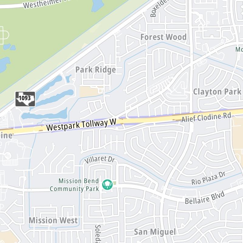
This local toll road serves several key cities, including Houston, Richmond, and Katy. The road map of the Westpark Tollway shows exits and tolling points on the road.

A complete list of exits and other points-of-interest may be found below the map.

View Map ▾Exit / POI List ▾

You may pan and zoom the interactive map. There are markers you may select for a separate map of that point of interest or location, which includes any nearby dining, gas, EV charging, hotels and other services.

Advertising
Advertising

The Westpark Tollway Toll Map

This map of the Westpark Tollway displays markers for exits and tolling points, which you can select to get a close-up map of that point of interest or location.

The points-of-interest shown on this map are also listed below, ordered from west to east.

Advertising
Advertising

List Of Exits / Points Of Interest For The Westpark Tollway

Select an exit or other location to get a separate map, including locations of available gas, EV charging, fast-food and other dining options, plus current weather and driving conditions.

FM 1093

FM 1093 — Katy

View Map & Info

▸ GPS 29.696592000 X -95.820391000
NOTES:

FBCTRA Fort Bend County Toll Road Authority manages this segment.

FM 723/Spring Green Blvd

FM 723/Spring Green Blvd — Katy

View Map & Info

▸ GPS 29.697498000 X -95.812998000
NOTES: WB Off/EB On

FBCTRA Fort Bend County Toll Road Authority manages this segment.

Katy Gaston Westbound Toll Gantry

Katy Gaston Westbound Toll Gantry — Katy

View Map & Info

▸ GPS 29.698539000 X -95.798208000
NOTES:

FBCTRA Fort Bend County Toll Road Authority manages this segment.

Katy Gaston Eastbound Toll Gantry

Katy Gaston Eastbound Toll Gantry — Richmond

View Map & Info

▸ GPS 29.698415000 X -95.798199000
NOTES:

FBCTRA Fort Bend County Toll Road Authority manages this segment.

Katy

Katy — Richmond

View Map & Info

▸ GPS 29.698817000 X -95.792721000
NOTES: Gaston Road

FBCTRA Fort Bend County Toll Road Authority manages this segment.

Gaston Road

Gaston Road — Richmond

View Map & Info

▸ GPS 29.699563000 X -95.785010000
NOTES: WB Exit to Katy Gaston Rd

FBCTRA Fort Bend County Toll Road Authority manages this segment.

SH 99 / Grand Parkway

SH 99 / Grand Parkway — Richmond

View Map & Info

▸ GPS 29.700554000 X -95.775725000
NOTES: No WB Entrance

FBCTRA Fort Bend County Toll Road Authority manages this segment.

Peek Road

Peek Road — Richmond

View Map & Info

▸ GPS 29.701552000 X -95.760199000
NOTES: WB Off/EB On

FBCTRA Fort Bend County Toll Road Authority manages this segment.

Peek Eastbound Toll Gantry

Peek Eastbound Toll Gantry — Richmond

View Map & Info

▸ GPS 29.702335000 X -95.750737000
NOTES:

FBCTRA Fort Bend County Toll Road Authority manages this segment.

Peek Westbound Toll Gantry

Peek Westbound Toll Gantry — Richmond

View Map & Info

▸ GPS 29.702462000 X -95.750429000
NOTES:

FBCTRA Fort Bend County Toll Road Authority manages this segment.

Mason Road

Mason Road — Richmond

View Map & Info

▸ GPS 29.702953000 X -95.742888000
NOTES: EB On/Off Only

FBCTRA Fort Bend County Toll Road Authority manages this segment.

Grand Mission Boulevard

Grand Mission Boulevard — Richmond

View Map & Info

▸ GPS 29.704845000 X -95.719809000
NOTES: WB Off/EB On

FBCTRA Fort Bend County Toll Road Authority manages this segment.

Westmoor Eastbound Toll Gantry

Westmoor Eastbound Toll Gantry — Richmond

View Map & Info

▸ GPS 29.705936000 X -95.706511000
NOTES:

FBCTRA Fort Bend County Toll Road Authority manages this segment.

Westmoor Westbound Toll Gantry

Westmoor Westbound Toll Gantry — Richmond

View Map & Info

▸ GPS 29.705890000 X -95.708536000
NOTES:

FBCTRA Fort Bend County Toll Road Authority manages this segment.

FM 1093 / FM 1464 / Westheimer Rd

FM 1093 / FM 1464 / Westheimer Rd — Richmond

View Map & Info

▸ GPS 29.707257000 X -95.691360000
NOTES: WB On/EB Off

FBCTRA Fort Bend County Toll Road Authority manages this segment.

FM 1464 / FM 1093

FM 1464 / FM 1093 — Houston

View Map & Info

▸ GPS 29.707584000 X -95.688006000
NOTES: WB Off/EB On

FBCTRA Fort Bend County Toll Road Authority manages this segment.

Westheimer Pl Dr

Westheimer Pl Dr — Houston

View Map & Info

▸ GPS 29.708982000 X -95.670313000
NOTES: EB On Only

HCTRA Harris County Toll Road Authority manages this segment.

Westpark Drive

Westpark Drive — Houston

View Map & Info

▸ GPS 29.709239000 X -95.666454000
NOTES: WB Off Only

HCTRA Harris County Toll Road Authority manages this segment.

SH 6 / Old Addicks

SH 6 / Old Addicks — Houston

View Map & Info

▸ GPS 29.710992000 X -95.643967000
NOTES: Howell Rd

HCTRA Harris County Toll Road Authority manages this segment.

Eldridge Parkway

Eldridge Parkway — Houston

View Map & Info

▸ GPS 29.712692000 X -95.623930000
NOTES: WB Off/EB On

HCTRA Harris County Toll Road Authority manages this segment.

Cook Road

Cook Road — Houston

View Map & Info

▸ GPS 29.714610000 X -95.600513000
NOTES: EB Off Only

HCTRA Harris County Toll Road Authority manages this segment.

W Houston Center Blvd / Dairy Ashford Rd

W Houston Center Blvd / Dairy Ashford Rd — Houston

View Map & Info

▸ GPS 29.715405000 X -95.592187000
NOTES: WB Off/EB On

HCTRA Harris County Toll Road Authority manages this segment.

Wilcrest West Tolling Zone / WB Gantry

Wilcrest West Tolling Zone / WB Gantry — Houston

View Map & Info

▸ GPS 29.716771000 X -95.575851000
NOTES:

HCTRA Harris County Toll Road Authority manages this segment.

Wilcrest East Mainline / EB Gantry

Wilcrest East Mainline / EB Gantry — Houston

View Map & Info

▸ GPS 29.717429000 X -95.566964000
NOTES:

HCTRA Harris County Toll Road Authority manages this segment.

Sam Houston Tollway/SH 8 Beltway

Sam Houston Tollway/SH 8 Beltway — Houston

View Map & Info

▸ GPS 29.718231000 X -95.557338000
NOTES:

HCTRA Harris County Toll Road Authority manages this segment.

Gessner Road

Gessner Road — Houston

View Map & Info

▸ GPS 29.719673000 X -95.539055000
NOTES: No WB Exit

HCTRA Harris County Toll Road Authority manages this segment.

Fondren Road

Fondren Road — Houston

View Map & Info

▸ GPS 29.721194000 X -95.520170000
NOTES: No WB Entrance

HCTRA Harris County Toll Road Authority manages this segment.

Fondren East Tolling Zone / EB Gantry

Fondren East Tolling Zone / EB Gantry — Houston

View Map & Info

▸ GPS 29.721478000 X -95.516573000
NOTES:

HCTRA Harris County Toll Road Authority manages this segment.

West Hillcroft Tolling Zone / WB Gantry

West Hillcroft Tolling Zone / WB Gantry — Houston

View Map & Info

▸ GPS 29.722791000 X -95.501741000
NOTES:

HCTRA Harris County Toll Road Authority manages this segment.

I–69/US 59/Southwest Freeway

I–69/US 59/Southwest Freeway — Houston

View Map & Info

▸ GPS 29.723525000 X -95.491314000
NOTES:

HCTRA Harris County Toll Road Authority manages this segment.

Westpark Dr / S Rice Ave

Westpark Dr / S Rice Ave — Houston

View Map & Info

▸ GPS 29.725656000 X -95.468564000
NOTES: WB On Only

HCTRA Harris County Toll Road Authority manages this segment.

Westpark Drive East

Westpark Drive East — Houston

View Map & Info

▸ GPS 29.725520000 X -95.467870000
NOTES: EB Off Only

HCTRA Harris County Toll Road Authority manages this segment.

Post Oak Boulevard

Post Oak Boulevard — Houston

View Map & Info

▸ GPS 29.731716000 X -95.460621000
NOTES: EB Off Only

HCTRA Harris County Toll Road Authority manages this segment.

Advertising
Advertising

EXPLORE TEXAS

Journey to key destinations around and adjacent to Texas!

Map Of This Region ▹

Communities in this metro area include Dallas, Fort Worth, Plano, Addison, Frisco, Grand Prairie, Arlington, Carrrollton, and Lake Dallas.

Individual toll maps for this region are listed below.

Map Of This Region ▹

Communities in this metro area include Houston, Humble, Tomball, Sugar Land, Galveston, Pearland, and Katy.

Individual toll maps for this region are listed below.

Map Of This Region ▹

Communities in this metro area include Austin, Pflugerville, Round Rock, Georgetown, Cedar Park, Mustang Ridge, Manor, Serenada, Sunset Valley, and Hutto.

Individual toll maps for this region are listed below.

Map Of This Region ▹

Communities in this metro area include Tyler, Wood Springs, Noonday, and Whitehouse.

Individual toll maps for this region are listed below.

Map Of This Region ▹

Communities in this metro area include Brownsville, Heroica Matamoros, Tamaulipas, San Benito, Harlingen, and Rancho Viejo.

Individual toll maps for this region are listed below.

Map Of This Region ▹

Communities in this metro area include Lawton, Fort Sill, Geronimo, and Cache.

Individual toll maps for this region are listed below.

Advertising
Advertising