Carquinez Bridge Map

Static map a segment of the Carquinez Bridge

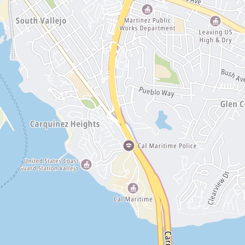
Using The Interactive Toll Map

This bridge serves Crockett and Vallejo. The road map of the Carquinez Bridge shows exits and tolling points on the road.

A complete list of exits and other points-of-interest may be found below the map.

View Map ▾Exit / POI List ▾

You may pan and zoom the interactive map. There are markers you may select for a separate map of that point of interest or location, which includes any nearby dining, gas, EV charging, hotels and other services.

Advertising
Advertising

The Carquinez Bridge Toll Map

This map of the Carquinez Bridge displays markers for exits and tolling points, which you can select to get a close-up map of that point of interest or location.

The points-of-interest shown on this map are also listed below, ordered from west to east.

Advertising
Advertising

List Of Exits / Points Of Interest For The Carquinez Bridge

Select an exit or other location to get a separate map, including locations of available gas, EV charging, fast-food and other dining options, plus current weather and driving conditions.

Cummings Skyway

Exit 26Cummings Skyway — Crockett

View Map & Info

▸ GPS 38.045141000 X -122.238055000
NOTES:

BATA Bay Area Toll Authority manages this segment.

Pomona Street/San Pablo Avenue

Exit 27Pomona Street/San Pablo Avenue — Crockett

View Map & Info

▸ GPS 38.052624000 X -122.227411000
NOTES:

BATA Bay Area Toll Authority manages this segment.

Carquinez Bridge Toll Plaza

Carquinez Bridge Toll Plaza — Vallejo

View Map & Info

▸ GPS 38.069100000 X -122.226697000
NOTES:

BATA Bay Area Toll Authority manages this segment.

Sonoma Boulevard

Exit 29ASonoma Boulevard — Vallejo

View Map & Info

▸ GPS 38.076410000 X -122.231855000
NOTES: WB On/EB Off

BATA Bay Area Toll Authority manages this segment.

Sequoia Ave

Exit 29BSequoia Ave — Vallejo

View Map & Info

▸ GPS 38.078062000 X -122.232602000
NOTES: No EB On

BATA Bay Area Toll Authority manages this segment.

Magazine Street

Exit 29B/29CMagazine Street — Vallejo

View Map & Info

▸ GPS 38.085263000 X -122.232821000
NOTES:

BATA Bay Area Toll Authority manages this segment.

I–780

Exit 30I–780 — Vallejo

View Map & Info

▸ GPS 38.091527000 X -122.230351000
NOTES:

BATA Bay Area Toll Authority manages this segment.

Advertising
Advertising

EXPLORE CALIFORNIA

Journey to key destinations around and adjacent to California!

Map Of This Region ▹

Communities in this metro area include Los Angeles, Long Beach, Irvine, San Juan Capistrano, and Santa Ana.

Individual toll maps for this region are listed below.

Map Of This Region ▹

Communities in this metro area include San Diego, Chula Vista, and Tijuana, Mexico.

Individual toll maps for this region are listed below.

Advertising
Advertising