Garden State Parkway Map

Advertising
Advertising
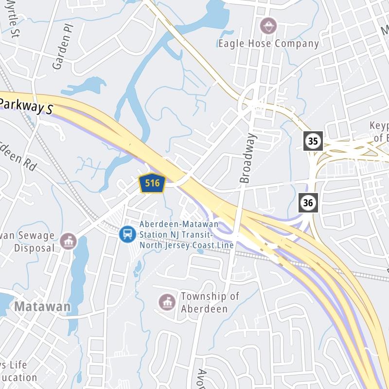
Static map a segment of the Garden State Parkway

A Quick Look At The Garden State Parkway

GSP and The Parkway are other names for this roadway. This state toll road serves several key cities, including Toms River, Middletown, Brick, Perth Amboy, Woodbridge Township, Newark, Cape May, Stone Harbor, Atlantic City, and Ocean City.

The static map seen here shows a segment of The Garden State Parkway at Route 35. The entirety of The Garden State Parkway can be seen in the fully-interactive map below, which includes linked markers. You may resize and reposition the interactive map to orient the road in relation to other landmarks.

There is also a complete list of exits below the interactive map.

View Map ▾Exit / POI List ▾

What Does It Cost To Use The Garden State Parkway?

Tolls For Cars, SUVs, Pickups, etc.

▹ Toll as of March 1, 2024.

The total toll for using the Garden State Parkway is $11.50, if you are using a compatible transponder, RFID sticker or other pass.

NOTE: The rates shown are the maximum toll incurred. Your trip may have a lower rate.

Transponders You Can Use

For drivers paying with a transponder, the following passes will work on the Garden State Parkway

  • e-zpass
  • epass xtra
  • i-pass
  • quick pass
  • riverlink
  • sunpass pro
  • uni

Learn about transponders and accounts in New Jersey.

Without a compatible pass or transponder, the toll will be $12.10.

View Map ▾All Tolls / Calculator ▸

Our new toll and trip calculator is being constructed. For most roads, you can still use the legacy calculator for current, accurate tolls.

Advertising
Advertising

Using The Interactive Toll Map

You may pan and zoom the interactive map. There are markers you may select for a separate map of that point of interest or location, which will show any nearby dining, gas, EV charging, hotels and other services.

A complete list of exits and other points-of-interest may be found below the map. Exits and gantries will display the toll agency responsible for tolls on that portion of the roadway.

View Map ▾Exit / POI List ▾

Advertising
Advertising

The Garden State Parkway Toll Map

This map of the Garden State Parkway displays markers for exits and tolling points, which you can select to get a close-up map of that point of interest or location.

The points-of-interest shown on this map are also listed below, ordered from south to north.

Discover New Jersey Attractions

Advertising
Advertising

List Of Exits / Points Of Interest For The Garden State Parkway

Select an exit or other location to get a separate map, including locations of available gas, EV charging, fast-food and other dining options, plus current weather and driving conditions.

Cape May: Ocean Drive / Shore Road

Cape May: Ocean Drive / Shore Road — Cape May

View Map & Info

▸ GPS 38.960809000 X -74.903993000
NOTES:

NJTA New Jersey Turnpike Authority manages this segment.

NJ 47: Wildwood Blvd

Exit 4NJ 47: Wildwood Blvd — Rio Grande

View Map & Info

▸ GPS 39.005070000 X -74.868609000
NOTES:

NJTA New Jersey Turnpike Authority manages this segment.

NJ 47: S Wildwood Blvd

Exit 4BNJ 47: S Wildwood Blvd — Rio Grande

View Map & Info

▸ GPS 39.011887000 X -74.865063000
NOTES:

NJTA New Jersey Turnpike Authority manages this segment.

NJ 47: N Wildwood Blvd

Exit 4ANJ 47: N Wildwood Blvd — Rio Grande

View Map & Info

▸ GPS 39.011887000 X -74.865063000
NOTES:

NJTA New Jersey Turnpike Authority manages this segment.

North Wildwood: N Wildwood Blvd

Exit 6North Wildwood: N Wildwood Blvd — Burleigh

View Map & Info

▸ GPS 39.043439000 X -74.846254000
NOTES:

NJTA New Jersey Turnpike Authority manages this segment.

NJ 9

Exit 9NJ 9 — Mayville

View Map & Info

▸ GPS 39.066398000 X -74.830176000
NOTES: Mayville: Shell Bay Ave

NJTA New Jersey Turnpike Authority manages this segment.

CR 657 West

Exit 10ACR 657 West — Cape May

View Map & Info

▸ GPS 39.085329000 X -74.814968000
NOTES: Stone Harbor

NJTA New Jersey Turnpike Authority manages this segment.

CR 657 East

Exit 10BCR 657 East — Cape May

View Map & Info

▸ GPS 39.085329000 X -74.814968000
NOTES: Stone Harbor

NJTA New Jersey Turnpike Authority manages this segment.

609 West to US 9: Crest Haven Rd

Exit 11609 West to US 9: Crest Haven Rd — Stone Harbor

View Map & Info

▸ GPS 39.100195000 X -74.805508000
NOTES:

NJTA New Jersey Turnpike Authority manages this segment.

US 9/Shore Road

Exit 12US 9/Shore Road — Stone Harbor

View Map & Info

▸ GPS 39.108197000 X -74.797244000
NOTES:

NJTA New Jersey Turnpike Authority manages this segment.

CR 601/Avalon Blvd

Exit 13CR 601/Avalon Blvd — Avalon

View Map & Info

▸ GPS 39.126041000 X -74.771924000
NOTES:

NJTA New Jersey Turnpike Authority manages this segment.

Sea Isle City: Sea Isle Blvd

Exit 17Sea Isle City: Sea Isle Blvd — Sea Isle City

View Map & Info

▸ GPS 39.171593000 X -74.730638000
NOTES:

NJTA New Jersey Turnpike Authority manages this segment.

Ocean View Service Area

Ocean View Service Area — Ocean View

View Map & Info

▾ AVAILABLE GAS AND EV ▾

  • gas

    gas

  • diesel

    diesel

  • truck parking

    truck
    parking

Cape May Toll Plaza

Cape May Toll Plaza — Upper Township

View Map & Info

▸ GPS 39.193744000 X -74.709679000
NOTES:

NJTA New Jersey Turnpike Authority manages this segment.

Seaville: NJ 50 / US 9

Exit 20Seaville: NJ 50 / US 9 — Seaville

View Map & Info

▸ GPS 39.202139000 X -74.699953000
NOTES:

NJTA New Jersey Turnpike Authority manages this segment.

CR 623/Roosevelt Blvd

Exit 25CR 623/Roosevelt Blvd — Marmora

View Map & Info

▸ GPS 39.262058000 X -74.642620000
NOTES: to US 9

NJTA New Jersey Turnpike Authority manages this segment.

Somers Point: New Road / US 9

Exit 29Somers Point: New Road / US 9 — Ocean City

View Map & Info

▸ GPS 39.308448000 X -74.618328000
NOTES:

NJTA New Jersey Turnpike Authority manages this segment.

Somers Point: Laurel Drive

Exit 30Somers Point: Laurel Drive — Ocean City

View Map & Info

▸ GPS 39.325528000 X -74.615965000
NOTES:

NJTA New Jersey Turnpike Authority manages this segment.

Tilton Road / US 40 / US 322

Exit 36Tilton Road / US 40 / US 322 — Egg Harbor Township

View Map & Info

▸ GPS 39.398625000 X -74.560952000
NOTES: to Pleasantville and Northfield

NJTA New Jersey Turnpike Authority manages this segment.

Washington Ave / US 40 / US 322

Exit 37Washington Ave / US 40 / US 322

View Map & Info

▸ GPS 39.405004000 X -74.557367000
NOTES: Pleasantville

NJTA New Jersey Turnpike Authority manages this segment.

Atlantic City Expressway

Exit 38Atlantic City Expressway — Pleasantville

View Map & Info

▸ GPS 39.414053000 X -74.552769000
NOTES:

NJTA New Jersey Turnpike Authority manages this segment.

White Horse Pike E

Exit 40White Horse Pike E — Pomona

View Map & Info

▸ GPS 39.452290000 X -74.536238000
NOTES: US 30

NJTA New Jersey Turnpike Authority manages this segment.

Frank Sinatra Service Area

Frank Sinatra Service Area — Galloway

View Map & Info

▾ AVAILABLE GAS AND EV ▾

  • gas

    gas

  • diesel

    diesel

  • truck parking

    truck
    parking

Jimmie Leeds Road

Exit 41Jimmie Leeds Road — Pomona

View Map & Info

▸ GPS 39.474291000 X -74.526826000
NOTES:

NJTA New Jersey Turnpike Authority manages this segment.

Route 575: Pomona Rd

Exit 44Route 575: Pomona Rd — Pamona

View Map & Info

▸ GPS 39.507765000 X -74.519827000
NOTES:

NJTA New Jersey Turnpike Authority manages this segment.

Port Republic: New York Road / US 9

Exit 48Port Republic: New York Road / US 9 — Smithville

View Map & Info

▸ GPS 39.547197000 X -74.466837000
NOTES:

NJTA New Jersey Turnpike Authority manages this segment.

New Gretna: Amasa Landing Rd / US 9

Exit 50New Gretna: Amasa Landing Rd / US 9 — New Gretna

View Map & Info

▸ GPS 39.580335000 X -74.457096000
NOTES:

NJTA New Jersey Turnpike Authority manages this segment.

New Gretna: E Green Bush Rd

Exit 52New Gretna: E Green Bush Rd — New Gretna

View Map & Info

▸ GPS 39.609010000 X -74.431201000
NOTES:

NJTA New Jersey Turnpike Authority manages this segment.

Tuckerton

Exit 58Tuckerton — Little Egg Harbor

View Map & Info

▸ GPS 39.653287000 X -74.343663000
NOTES: Trenton: County Rd 539

NJTA New Jersey Turnpike Authority manages this segment.

NJ Rte 72 East: Long Beach Isl

Exit 63ANJ Rte 72 East: Long Beach Isl — Manahawkin

View Map & Info

▸ GPS 39.707522000 X -74.283098000
NOTES:

NJTA New Jersey Turnpike Authority manages this segment.

NJ Rte 72: Manahawkin

Exit 63NJ Rte 72: Manahawkin — Manahawkin

View Map & Info

▸ GPS 39.712226000 X -74.280094000
NOTES: Long Beach Isl

NJTA New Jersey Turnpike Authority manages this segment.

NJ Rte 72 West: Pemberton

Exit 63BNJ Rte 72 West: Pemberton — Manahawkin

View Map & Info

▸ GPS 39.712111000 X -74.278421000
NOTES:

NJTA New Jersey Turnpike Authority manages this segment.

County Rte 554

Exit 67County Rte 554 — Barnegat Township

View Map & Info

▸ GPS 39.759477000 X -74.251139000
NOTES:

NJTA New Jersey Turnpike Authority manages this segment.

County Rte 532

Exit 69County Rte 532 — Forked River

View Map & Info

▸ GPS 39.792715000 X -74.236977000
NOTES:

NJTA New Jersey Turnpike Authority manages this segment.

Lacey Road

Exit 74Lacey Road — Forked River

View Map & Info

▸ GPS 39.863638000 X -74.219443000
NOTES:

NJTA New Jersey Turnpike Authority manages this segment.

Celia Cruz Service Area

Celia Cruz Service Area — Lanoka Harbor

View Map & Info

▾ AVAILABLE GAS AND EV ▾

  • gas

    gas

  • ev

    ev

Berkeley: Pinewald Keswick Rd

Exit 77Berkeley: Pinewald Keswick Rd — Berkeley

View Map & Info

▸ GPS 39.892895000 X -74.212861000
NOTES:

NJTA New Jersey Turnpike Authority manages this segment.

Beachwood

Exit 80Beachwood — Beachwood

View Map & Info

▸ GPS 39.942598000 X -74.208934000
NOTES: South Toms River

NJTA New Jersey Turnpike Authority manages this segment.

Lakehurst Road

Exit 81Lakehurst Road — Toms River

View Map & Info

▸ GPS 39.956654000 X -74.206232000
NOTES:

NJTA New Jersey Turnpike Authority manages this segment.

Seaside Heights: NJ 37 East

Exit 82Seaside Heights: NJ 37 East — Toms River

View Map & Info

▸ GPS 39.961178000 X -74.206176000
NOTES:

NJTA New Jersey Turnpike Authority manages this segment.

Lakehurst: NJ 37 West

Exit 82ALakehurst: NJ 37 West — Toms River

View Map & Info

▸ GPS 39.966638000 X -74.207493000
NOTES:

NJTA New Jersey Turnpike Authority manages this segment.

Lakewood: US 9 / NJ 166 / County 571

Exit 83Lakewood: US 9 / NJ 166 / County 571 — Lakewood Township

View Map & Info

▸ GPS 39.988331000 X -74.210651000
NOTES:

NJTA New Jersey Turnpike Authority manages this segment.

Route 70

Exit 89BRoute 70 — Lakewood Township

View Map & Info

▸ GPS 40.054640000 X -74.168518000
NOTES: Lakehurst

NJTA New Jersey Turnpike Authority manages this segment.

Route 528 NB

Exit 89Route 528 NB — Lakewood Township

View Map & Info

▸ GPS 40.065813000 X -74.162320000
NOTES: Airport Road S

NJTA New Jersey Turnpike Authority manages this segment.

Rt 549 Brick

Exit 90Rt 549 Brick — Brick

View Map & Info

▸ GPS 40.077407000 X -74.155741000
NOTES: Lakewood

NJTA New Jersey Turnpike Authority manages this segment.

Rt 549 Brick

Exit 91Rt 549 Brick — Brick

View Map & Info

▸ GPS 40.097267000 X -74.142679000
NOTES: Lakewood

NJTA New Jersey Turnpike Authority manages this segment.

I–195 W

Exit 98I–195 W — Wall Township

View Map & Info

▸ GPS 40.167042000 X -74.100574000
NOTES: 195 West

NJTA New Jersey Turnpike Authority manages this segment.

Judy Blume Service Area

Judy Blume Service Area — Wall Township

View Map & Info

▾ AVAILABLE GAS AND EV ▾

  • gas

    gas

  • diesel

    diesel

  • truck parking

    truck
    parking

Rt 33 East: Corlies Ave / Ocean Grove / Bradley Bch

Exit 100Rt 33 East: Corlies Ave / Ocean Grove / Bradley Bch — Neptune Township

View Map & Info

▸ GPS 40.213765000 X -74.097460000
NOTES:

NJTA New Jersey Turnpike Authority manages this segment.

Route 33 West: Corlies Ave/ Freehold

Exit 100BRoute 33 West: Corlies Ave/ Freehold — Neptune Township

View Map & Info

▸ GPS 40.214634000 X -74.097504000
NOTES:

NJTA New Jersey Turnpike Authority manages this segment.

Route 66: Corlies Ave / Asbury Park

Exit 100ARoute 66: Corlies Ave / Asbury Park — Neptune Township

View Map & Info

▸ GPS 40.216588000 X -74.097579000
NOTES:

NJTA New Jersey Turnpike Authority manages this segment.

Route 66: Asbury Ave / Asbury Park

Exit 102Route 66: Asbury Ave / Asbury Park — Asbury Park

View Map & Info

▸ GPS 40.239928000 X -74.088374000
NOTES:

NJTA New Jersey Turnpike Authority manages this segment.

Rt 18

Exit 105Rt 18 — Eatontown

View Map & Info

▸ GPS 40.280803000 X -74.084696000
NOTES: Rt 36

NJTA New Jersey Turnpike Authority manages this segment.

Route 520: Red Bank / Lincroft

Exit 109Route 520: Red Bank / Lincroft — Red Bank

View Map & Info

▸ GPS 40.336962000 X -74.099763000
NOTES:

NJTA New Jersey Turnpike Authority manages this segment.

Holmdel: Red Hill Rd / Van Schroik Rd

Exit 114Holmdel: Red Hill Rd / Van Schroik Rd — Holmdel

View Map & Info

▸ GPS 40.375297000 X -74.146891000
NOTES:

NJTA New Jersey Turnpike Authority manages this segment.

Garden State Arts Center

Exit 116Garden State Arts Center — Holmdel

View Map & Info

▸ GPS 40.389569000 X -74.178699000
NOTES:

NJTA New Jersey Turnpike Authority manages this segment.

Route 35

Exit 117Route 35 — Aberdeen Township

View Map & Info

▸ GPS 40.421058000 X -74.211855000
NOTES: Route 36

NJTA New Jersey Turnpike Authority manages this segment.

Route 35

Exit 117ARoute 35 — Aberdeen Township

View Map & Info

▸ GPS 40.422250000 X -74.216090000
NOTES: Route 36

NJTA New Jersey Turnpike Authority manages this segment.

Laurence Harbor

Exit 120Laurence Harbor — South Amboy

View Map & Info

▸ GPS 40.435460000 X -74.251578000
NOTES: Matawan

NJTA New Jersey Turnpike Authority manages this segment.

Bon Jovi Service Area

Bon Jovi Service Area — South Amboy

View Map & Info

▾ AVAILABLE GAS AND EV ▾

  • gas

    gas

  • diesel

    diesel

  • truck parking

    truck
    parking

Route 9 South

Exit 123Route 9 South — South Amboy

View Map & Info

▸ GPS 40.472155000 X -74.295428000
NOTES: S Amboy

NJTA New Jersey Turnpike Authority manages this segment.

Sayreville

Exit 124Sayreville — Sayreville

View Map & Info

▸ GPS 40.476457000 X -74.299172000
NOTES: S Amboy

NJTA New Jersey Turnpike Authority manages this segment.

Chevalier Avenue (NJ 35 / US 9)

Exit 125Chevalier Avenue (NJ 35 / US 9) — Sayreville

View Map & Info

▸ GPS 40.495493000 X -74.300145000
NOTES: Sayreville

NJTA New Jersey Turnpike Authority manages this segment.

Rtes 9 & 440

Exit 127Rtes 9 & 440 — Keasbey

View Map & Info

▸ GPS 40.519622000 X -74.300903000
NOTES: I

NJTA New Jersey Turnpike Authority manages this segment.

New Jersey Turnpike

Exit 129New Jersey Turnpike — Woodbridge Township

View Map & Info

▸ GPS 40.538616000 X -74.306363000
NOTES: to Rtes 9 & 440

NJTA New Jersey Turnpike Authority manages this segment.

US 1

Exit 130US 1 — Metuchen

View Map & Info

▸ GPS 40.552646000 X -74.317028000
NOTES:

NJTA New Jersey Turnpike Authority manages this segment.

Metro Park Station

Exit 131Metro Park Station — Metuchen

View Map & Info

▸ GPS 40.561993000 X -74.322034000
NOTES:

NJTA New Jersey Turnpike Authority manages this segment.

Gills Lane

Exit 131BGills Lane — Metuchen

View Map & Info

▸ GPS 40.568429000 X -74.326300000
NOTES: Middlesex Essex Tpk

NJTA New Jersey Turnpike Authority manages this segment.

Route 27: Lincoln Highway

Exit 132Route 27: Lincoln Highway — Metuchen

View Map & Info

▸ GPS 40.570161000 X -74.327660000
NOTES:

NJTA New Jersey Turnpike Authority manages this segment.

Colonia South Service Area

Colonia South Service Area — Colonia

View Map & Info

▾ AVAILABLE GAS AND EV ▾

  • gas

    gas

  • diesel

    diesel

Colonia North Service Area

Colonia North Service Area — Colonia

View Map & Info

▾ AVAILABLE GAS AND EV ▾

  • gas

    gas

  • diesel

    diesel

Clark: Brant Ave / Central Ave

Exit 135Clark: Brant Ave / Central Ave — Clark

View Map & Info

▸ GPS 40.626309000 X -74.304982000
NOTES:

NJTA New Jersey Turnpike Authority manages this segment.

Linden: Centennial Ave / N Stiles St

Exit 136Linden: Centennial Ave / N Stiles St — Cranford

View Map & Info

▸ GPS 40.641732000 X -74.288954000
NOTES:

NJTA New Jersey Turnpike Authority manages this segment.

Route 28

Exit 137Route 28 — Cranford

View Map & Info

▸ GPS 40.658135000 X -74.287110000
NOTES: Westfield Ave

NJTA New Jersey Turnpike Authority manages this segment.

Rt 509 Kenilworth: Galloping Hill Rd

Exit 138Rt 509 Kenilworth: Galloping Hill Rd — Cranford

View Map & Info

▸ GPS 40.679795000 X -74.277954000
NOTES:

NJTA New Jersey Turnpike Authority manages this segment.

Chestnut Street

Exit 139AChestnut Street — Cranford

View Map & Info

▸ GPS 40.686098000 X -74.274349000
NOTES:

NJTA New Jersey Turnpike Authority manages this segment.

Route 82: West Union / Chestnut St

Exit 139BRoute 82: West Union / Chestnut St — Cranford

View Map & Info

▸ GPS 40.689431000 X -74.270706000
NOTES:

NJTA New Jersey Turnpike Authority manages this segment.

US 22 / Route 82 East / Morris Ave

Exit 140US 22 / Route 82 East / Morris Ave — Union

View Map & Info

▸ GPS 40.694493000 X -74.261714000
NOTES:

NJTA New Jersey Turnpike Authority manages this segment.

US 22 / Route 82 West

Exit 140AUS 22 / Route 82 West — Union

View Map & Info

▸ GPS 40.697268000 X -74.256947000
NOTES: Route 82 West

NJTA New Jersey Turnpike Authority manages this segment.

Whitney Houston Service Area

Whitney Houston Service Area — Union

View Map & Info

▾ AVAILABLE GAS AND EV ▾

  • gas

    gas

  • diesel

    diesel

  • truck parking

    truck
    parking

Vauxhall Road

Exit 141Vauxhall Road — Union

View Map & Info

▸ GPS 40.699781000 X -74.251923000
NOTES:

NJTA New Jersey Turnpike Authority manages this segment.

I–78 Express Eastbound

Exit 142AI–78 Express Eastbound — Union

View Map & Info

▸ GPS 40.701983000 X -74.247737000
NOTES:

NJTA New Jersey Turnpike Authority manages this segment.

I–78 Express Westbound

Exit 142BI–78 Express Westbound — Union

View Map & Info

▸ GPS 40.705655000 X -74.245487000
NOTES:

NJTA New Jersey Turnpike Authority manages this segment.

Union Avenue / Maplewood

Exit 142CUnion Avenue / Maplewood — Union

View Map & Info

▸ GPS 40.708813000 X -74.244875000
NOTES:

NJTA New Jersey Turnpike Authority manages this segment.

Lyons Avenue

Exit 143BLyons Avenue — Irvington

View Map & Info

▸ GPS 40.718855000 X -74.235304000
NOTES: Hillside

NJTA New Jersey Turnpike Authority manages this segment.

Lyons Avenue

Exit 143ALyons Avenue — Irvington

View Map & Info

▸ GPS 40.718855000 X -74.235304000
NOTES: Maplewood

NJTA New Jersey Turnpike Authority manages this segment.

Lyons Avenue

Exit 143Lyons Avenue — Irvington

View Map & Info

▸ GPS 40.732025000 X -74.221604000
NOTES: Springfield Ave

NJTA New Jersey Turnpike Authority manages this segment.

South Orange Avenue

Exit 144South Orange Avenue — Irvington

View Map & Info

▸ GPS 40.739381000 X -74.216465000
NOTES:

NJTA New Jersey Turnpike Authority manages this segment.

I–280

Exit 145I–280 — Newark

View Map & Info

▸ GPS 40.755230000 X -74.210089000
NOTES:

NJTA New Jersey Turnpike Authority manages this segment.

Springdale Ave / Parkway Dr

Exit 147Springdale Ave / Parkway Dr — East Orange

View Map & Info

▸ GPS 40.776447000 X -74.201853000
NOTES:

NJTA New Jersey Turnpike Authority manages this segment.

Bloomfield Avenue

Exit 148Bloomfield Avenue — Bloomfield

View Map & Info

▸ GPS 40.789431000 X -74.195506000
NOTES:

NJTA New Jersey Turnpike Authority manages this segment.

Belleville Avenue

Exit 149Belleville Avenue — Bloomfield

View Map & Info

▸ GPS 40.799127000 X -74.189154000
NOTES:

NJTA New Jersey Turnpike Authority manages this segment.

Hoover Avenue

Exit 150Hoover Avenue — Bloomfield

View Map & Info

▸ GPS 40.810070000 X -74.180762000
NOTES:

NJTA New Jersey Turnpike Authority manages this segment.

Watchung Avenue

Exit 151Watchung Avenue — Bloomfield

View Map & Info

▸ GPS 40.828763000 X -74.176478000
NOTES:

NJTA New Jersey Turnpike Authority manages this segment.

Connie Chung Service Area

Connie Chung Service Area — Bloomfield

View Map & Info

▾ AVAILABLE GAS AND EV ▾

  • gas

    gas

  • diesel

    diesel

  • truck parking

    truck
    parking

Larry Doby Service Area

Larry Doby Service Area — Bloomfield

View Map & Info

▾ AVAILABLE GAS AND EV ▾

  • gas

    gas

  • diesel

    diesel

  • ev

    ev

Route 3 East

Exit 153ARoute 3 East — Clifton

View Map & Info

▸ GPS 40.847392000 X -74.179199000
NOTES:

NJTA New Jersey Turnpike Authority manages this segment.

Route 3 West / Route 46 West

Exit 153BRoute 3 West / Route 46 West — Clifton

View Map & Info

▸ GPS 40.852465000 X -74.174921000
NOTES:

NJTA New Jersey Turnpike Authority manages this segment.

Route 3

Exit 153Route 3 — Clifton

View Map & Info

▸ GPS 40.853985000 X -74.176022000
NOTES:

NJTA New Jersey Turnpike Authority manages this segment.

US 46

Exit 154US 46 — Clifton

View Map & Info

▸ GPS 40.873808000 X -74.166519000
NOTES: Piaget Avenue

NJTA New Jersey Turnpike Authority manages this segment.

Clifton / Paterson

Exit 155AClifton / Paterson — Clifton

View Map & Info

▸ GPS 40.878231000 X -74.166033000
NOTES:

NJTA New Jersey Turnpike Authority manages this segment.

Hazel Street

Exit 155BHazel Street — Clifton

View Map & Info

▸ GPS 40.883400000 X -74.163235000
NOTES:

NJTA New Jersey Turnpike Authority manages this segment.

Clifton

Exit 156Clifton — Clifton

View Map & Info

▸ GPS 40.889658000 X -74.131264000
NOTES: River Dr

NJTA New Jersey Turnpike Authority manages this segment.

Elmwood Park: US 46 / River Dr

Exit 157Elmwood Park: US 46 / River Dr — Clifton

View Map & Info

▸ GPS 40.893333000 X -74.119928000
NOTES:

NJTA New Jersey Turnpike Authority manages this segment.

I–80

Exit 159I–80 — Elmwood Park

View Map & Info

▸ GPS 40.905221000 X -74.105407000
NOTES:

NJTA New Jersey Turnpike Authority manages this segment.

Passaic St / Route 208 / Paramus Rd

Exit 160Passaic St / Route 208 / Paramus Rd — Elmwood Park

View Map & Info

▸ GPS 40.920126000 X -74.085717000
NOTES:

NJTA New Jersey Turnpike Authority manages this segment.

Route 4

Exit 161Route 4 — Paramus

View Map & Info

▸ GPS 40.922706000 X -74.079955000
NOTES:

NJTA New Jersey Turnpike Authority manages this segment.

Route 17

Exit 163Route 17 — Paramus

View Map & Info

▸ GPS 40.938391000 X -74.071336000
NOTES:

NJTA New Jersey Turnpike Authority manages this segment.

Oradell

Exit 165Oradell — Paramus

View Map & Info

▸ GPS 40.963556000 X -74.065069000
NOTES: Ridgewood

NJTA New Jersey Turnpike Authority manages this segment.

Washington / Highland Ave / Linwood Ave E

Exit 166Washington / Highland Ave / Linwood Ave E — Paramus

View Map & Info

▸ GPS 40.976826000 X -74.070458000
NOTES:

NJTA New Jersey Turnpike Authority manages this segment.

Washington

Exit 168Washington — Washington Township

View Map & Info

▸ GPS 40.998689000 X -74.071050000
NOTES: Westwood

NJTA New Jersey Turnpike Authority manages this segment.

Chestnut Ridge Rd / Glen Rd

Exit 171Chestnut Ridge Rd / Glen Rd — Woodcliff Lake

View Map & Info

▸ GPS 41.036819000 X -74.071636000
NOTES:

NJTA New Jersey Turnpike Authority manages this segment.

James Gandolfini Service Area

James Gandolfini Service Area — Montvale

View Map & Info

▾ AVAILABLE GAS AND EV ▾

  • gas

    gas

  • diesel

    diesel

  • truck parking

    truck
    parking

Grand Avenue

Exit 172Grand Avenue — Woodcliff Lake

View Map & Info

▸ GPS 41.055549000 X -74.065309000
NOTES:

NJTA New Jersey Turnpike Authority manages this segment.

New York State Thruway

New York State Thruway — Nanuet NY

View Map & Info

▸ GPS 41.097440000 X -74.040541000
NOTES:

NJTA New Jersey Turnpike Authority manages this segment.

Advertising
Advertising

EXPLORE NEW JERSEY

Journey to key destinations around and adjacent to New Jersey!

Map Of This Region ▹

Communities in this metro area include Camden, Burlington, Palmyra, Pennsauken, Cherry Hill, Gloucester City, Trenton, Wilmington, Delaware, Philadelphia, Pennsylvania, Tacony, Pennsylvania, and Bristol, Pennsylvania.

Individual toll maps for this region are listed below.

Map Of This Region ▹

Communities in this metro area include Atlantic City, Ocean City, Cape May, Wildwood, Egg Harbor Township, and Somers Point.

Individual toll maps for this region are listed below.

Map Of This Region ▹

Communities in this metro area include Knowlton Township, Trenton, Phillipsburg, Easton, Pennsylvania, Lambertville, Ewing, Morrisville, Pennsylvania, and Stroudsburg, Pennsylvania.

Individual toll maps for this region are listed below.

Map Of This Region ▹

Communities in this metro area include Wilmington, Middletown, Newark, and Carneys Point, New Jersey.

Individual toll maps for this region are listed below.

Map Of This Region ▹

Communities in this metro area include Philadelphia, King Of Prussia, Valley Forge, West Chester, Bristol, Burlington, New Jersey, Morrisville, Trenton, New Jersey, Palmyra, New Jersey, Wilmington, Delaware, and Camden, New Jersey.

Individual toll maps for this region are listed below.

Map Of This Region ▹

Communities in this metro area include Scranton, Wilkes Barre, Stroudsburg, Clarks Summit, and Knowlton Township, New Jersey.

Individual toll maps for this region are listed below.

Advertising
Advertising
Turnpikes.com is proud to partner with the following: