State Route 1 Map

Static map a segment of State Route 1

Using The Interactive Toll Map

This state toll road serves several key cities, including Dover, Smyrna, Biddles Corner, Williamsburg, and Christiana.
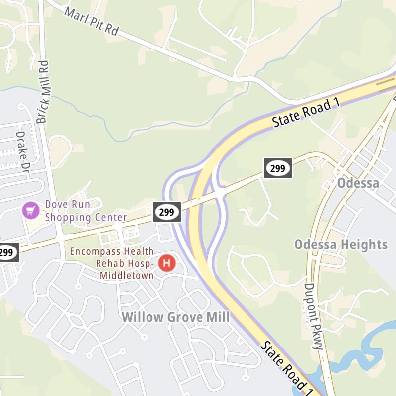
 The road map of State Route 1 shows exits and tolling points on the road.

A complete list of exits and other points-of-interest may be found below the map.

View Map ▾Exit / POI List ▾

You may pan and zoom the interactive map. There are markers you may select for a separate map of that point of interest or location, which includes any nearby dining, gas, EV charging, hotels and other services.

Advertising
Advertising

State Route 1 Toll Map

This map of State Route 1 displays markers for exits and tolling points, which you can select to get a close-up map of that point of interest or location.

The points-of-interest shown on this map are also listed below, ordered from south to north.

Advertising
Advertising

List Of Exits / Points Of Interest For State Route 1

Select an exit or other location to get a separate map, including locations of available gas, EV charging, fast-food and other dining options, plus current weather and driving conditions.

State Route 9 / Dover AFB Commercial Gate

Exit 91State Route 9 / Dover AFB Commercial Gate — Dover

View Map & Info

▸ GPS 39.106472000 X -75.455113000
NOTES:

DelDOT Delaware Department of Transportation manages this segment.

13th Street / Old Lebanon Road / Dover AFB Main Gate

Exit 9313th Street / Old Lebanon Road / Dover AFB Main Gate — Dover

View Map & Info

▸ GPS 39.121372000 X -75.479486000
NOTES:

DelDOT Delaware Department of Transportation manages this segment.

State Route 10 / Dover AFB North Gate

Exit 95State Route 10 / Dover AFB North Gate — Dover

View Map & Info

▸ GPS 39.130632000 X -75.492180000
NOTES:

DelDOT Delaware Department of Transportation manages this segment.

US 13

Exit 97US 13 — Dover

View Map & Info

▸ GPS 39.154972000 X -75.493437000
NOTES:

DelDOT Delaware Department of Transportation manages this segment.

State Route 8

Exit 98State Route 8 — Dover

View Map & Info

▸ GPS 39.165733000 X -75.492855000
NOTES:

DelDOT Delaware Department of Transportation manages this segment.

Dover Toll Plaza

Dover Toll Plaza — Dover

View Map & Info

▸ GPS 39.185033000 X -75.514476000
NOTES:

DelDOT Delaware Department of Transportation manages this segment.

SR 8 / US 13 / Dover Intl Speedway

Exit 104SR 8 / US 13 / Dover Intl Speedway — Dover

View Map & Info

▸ GPS 39.205231000 X -75.542673000
NOTES: Dover Downs

DelDOT Delaware Department of Transportation manages this segment.

SR 6 / SR 300 / US 13

Exit 114SR 6 / SR 300 / US 13 — Smyrna

View Map & Info

▸ GPS 39.282763000 X -75.589515000
NOTES:

DelDOT Delaware Department of Transportation manages this segment.

Smyrna Rest Area / US 13 / SR 6 / SR 300

Exit 119BSmyrna Rest Area / US 13 / SR 6 / SR 300 — Smyrna

View Map & Info

▸ GPS 39.328205000 X -75.621364000
NOTES:

DelDOT Delaware Department of Transportation manages this segment.

US 13 / SR 6 / SR 300

Exit 119AUS 13 / SR 6 / SR 300 — Smyrna

View Map & Info

▸ GPS 39.334005000 X -75.632505000
NOTES:

DelDOT Delaware Department of Transportation manages this segment.

US 13 / SR 6 / SR 300

Exit 119US 13 / SR 6 / SR 300 — Smyrna

View Map & Info

▸ GPS 39.332431000 X -75.628822000
NOTES:

DelDOT Delaware Department of Transportation manages this segment.

SR 299 / US 13 / US 301

Exit 136SR 299 / US 13 / US 301 — Middletown

View Map & Info

▸ GPS 39.455402000 X -75.674486000
NOTES:

DelDOT Delaware Department of Transportation manages this segment.

SR 896/Pole Bridge Rd

Exit 142SR 896/Pole Bridge Rd — Mt Pleasant

View Map & Info

▸ GPS 39.500360000 X -75.645514000
NOTES: to US 301

DelDOT Delaware Department of Transportation manages this segment.

Biddles Corner Toll Plaza

Biddles Corner Toll Plaza — Biddles Corner

View Map & Info

▸ GPS 39.525501000 X -75.650590000
NOTES:

DelDOT Delaware Department of Transportation manages this segment.

US 301

US 301 — St Georges

View Map & Info

▸ GPS 39.531243000 X -75.649634000
NOTES: SB Off/NB On

DelDOT Delaware Department of Transportation manages this segment.

US 13

Exit 148US 13 — St Georges

View Map & Info

▸ GPS 39.543721000 X -75.650649000
NOTES:

DelDOT Delaware Department of Transportation manages this segment.

SR 72 / SR 7 / US 13

Exit 152SR 72 / SR 7 / US 13 — Delaware City

View Map & Info

▸ GPS 39.579968000 X -75.661722000
NOTES:

DelDOT Delaware Department of Transportation manages this segment.

SR 71 / US 13

Exit 156A/156SR 71 / US 13 — New Castle

View Map & Info

▸ GPS 39.618579000 X -75.643828000
NOTES:

DelDOT Delaware Department of Transportation manages this segment.

US 40

Exit 160US 40 — New Castle

View Map & Info

▸ GPS 39.636872000 X -75.653178000
NOTES:

DelDOT Delaware Department of Transportation manages this segment.

SR 273

Exit 162SR 273 — New Castle

View Map & Info

▸ GPS 39.661246000 X -75.652565000
NOTES:

DelDOT Delaware Department of Transportation manages this segment.

SR 7 / Mall Road

Exit 164A/164SR 7 / Mall Road — New Castle

View Map & Info

▸ GPS 39.673738000 X -75.654003000
NOTES:

DelDOT Delaware Department of Transportation manages this segment.

I–95/DE TPKE / I–295 / I–495

Exit 165A/B/CI–95/DE TPKE / I–295 / I–495 — New Castle

View Map & Info

▸ GPS 39.681874000 X -75.656303000
NOTES:

DelDOT Delaware Department of Transportation manages this segment.

SR 58 / Churchmans Road / SR 7

Exit 166SR 58 / Churchmans Road / SR 7 — Newark

View Map & Info

▸ GPS 39.688930000 X -75.654408000
NOTES:

DelDOT Delaware Department of Transportation manages this segment.

Advertising
Advertising

EXPLORE DELAWARE

Journey to key destinations around and adjacent to Delaware!

Map Of This Region ▹

Communities in this metro area include Wilmington, Middletown, Newark, and Carneys Point, New Jersey.

Individual toll maps for this region are listed below.

Map Of This Region ▹

Communities in this metro area include Camden, Dover, Dover Afb, and Smyrna.

Individual toll maps for this region are listed below.

Map Of This Region ▹

Communities in this metro area include Camden, Burlington, Palmyra, Pennsauken, Cherry Hill, Gloucester City, Trenton, Wilmington, Delaware, Philadelphia, Pennsylvania, Tacony, Pennsylvania, and Bristol, Pennsylvania.

Individual toll maps for this region are listed below.

Map Of This Region ▹

Communities in this metro area include Philadelphia, King Of Prussia, Valley Forge, West Chester, Bristol, Burlington, New Jersey, Morrisville, Trenton, New Jersey, Palmyra, New Jersey, Wilmington, Delaware, and Camden, New Jersey.

Individual toll maps for this region are listed below.

Advertising
Advertising