Francis Scott Key Bridge Map

Advertising
Advertising

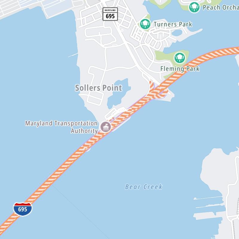
Exits Map For The Francis Scott Key Bridge

This map of the Francis Scott Key Bridge displays markers for exits and tolling points, which you can select to get a close-up map of that point of interest or location.

The points-of-interest shown on this map are also listed below, ordered from south to north.

See below for more comprehensive information about the Francis Scott Key Bridge

Advertising
Advertising
Static map a segment of the Francis Scott Key Bridge

A Quick Look At The Francis Scott Key Bridge

This bridge serves Baltimore, Dundalk, and Edgemere.

The static map seen here shows a segment of The Francis Scott Key Bridge at Broening Highway. The entirety of The Francis Scott Key Bridge can be seen in the fully-interactive map above, which includes linked markers. You may resize and reposition the interactive map to orient the road in relation to other landmarks.

There is also a complete list of exits below.

View Map Exit / POI List

Advertising
Advertising

What Does It Cost To Use The Francis Scott Key Bridge?

Tolls For Cars, SUVs, Pickups, etc.

▹ Toll as of April 29, 2021.

The total toll for using the Francis Scott Key Bridge is $4.00, if you are using a compatible transponder, RFID sticker or other pass.

Transponders You Can Use

For drivers paying with a transponder, the following passes will work on the Francis Scott Key Bridge

  • e-zpass
  • epass xtra
  • i-pass
  • quick pass
  • riverlink
  • sunpass pro
  • uni

Learn about transponders and accounts in Maryland.

View MapAll Tolls / Calculator ▸

Our new toll and trip calculator is being constructed. For most roads, you can still use the legacy calculator for current, accurate tolls.

Discover Maryland Attractions

Turnpikes.com has partnered with Tiqets.com to bring you these excusive deals on attractions!

Advertising
Advertising

List Of Exits / Points Of Interest For The Francis Scott Key Bridge

Select an exit or other location to get a separate map, including locations of available gas, EV charging, fast-food and other dining options, plus current weather and driving conditions.

Bethlehem Blvd / Peninsula Expressway

Exit 43Bethlehem Blvd / Peninsula Expressway — Edgemere

View Map & Info

▸ GPS 39.238384000 X -76.478441000
NOTES:

MDTA Maryland Transportation Authority manages this segment.

Broening Highway

Exit 44Broening Highway — Dundalk

View Map & Info

▸ GPS 39.232036000 X -76.506781000
NOTES:

MDTA Maryland Transportation Authority manages this segment.

MD 173/Hawkins Point Rd

Exit 1MD 173/Hawkins Point Rd — Baltimore

View Map & Info

▸ GPS 39.204987000 X -76.565511000
NOTES:

MDTA Maryland Transportation Authority manages this segment.

Advertising
Advertising

EXPLORE MARYLAND

Journey to key destinations around and adjacent to Maryland!

Map Of This Region ▹

Communities in this metro area include Washington, Dc, Fairfax County, Virginia, Loundoun County, Virginia, Montgomery County, Maryland, and Prince George's County, Maryland.

Individual toll maps for this region are listed below.

Map Of This Region ▹

Communities in this metro area include Wilmington, Middletown, Newark, and Carneys Point, New Jersey.

Individual toll maps for this region are listed below.

Advertising
Advertising
Turnpikes.com is proud to partner with the following: