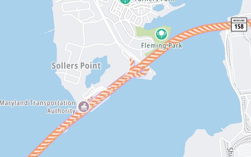
Map & services within two (2) miles
Interactive map shows available cameras, plus nearby fuel, food and lodging

See below for more about this area
Interactive map shows available cameras, plus nearby fuel, food and lodging
See below for more about this area
This is Exit 44 of the Francis Scott Key Bridge.
This junction is located in Dundalk.
This location is in the Baltimore area.
This location's approximate GPS Coordinates are 39.23204 x -76.50678.
Which directions can I travel from here?
From this junction, traffic can only enter going southbound. Traffic can only exit going northbound.
On to Bethlehem Blvd / Peninsula Expressway, about 1.6 miles away ►
◄ Back to MD 173/Hawkins Point Rd, about 3.9 miles away.
Which direction are tolls charged here?
Tolls are not charged or collected at this junction.
Above: Map image © TomTom Intl BVThe interactive map and lists on this page include key traveler services within two miles of this destination point.
You will find common services, including gas stations, truck stops, EV charging facilities, fast-food or family restaurants, and hotels. These are displayed on the interactive map as markers, which you can select for more information.
Current driving conditions and weather, along with a more complete list of key services, may be found below the map.

Sunny
50°F / 10°C
Feels Like:
46°F / 8.1°C
Visibility
10 Mi / 16.1 Km
3-Hour Precip:
0 In / 0.0 Cm
Northwest
Winds (NW)
17.3 MPH / 27.8 KPH
Gusts:
23 MPH / 37 KPH
▸ Get the full forecast for This Location | The Baltimore area
Conditions and forecasts provided in partnership with AccuWeather.

Weather provided in partnership with AccuWeather.
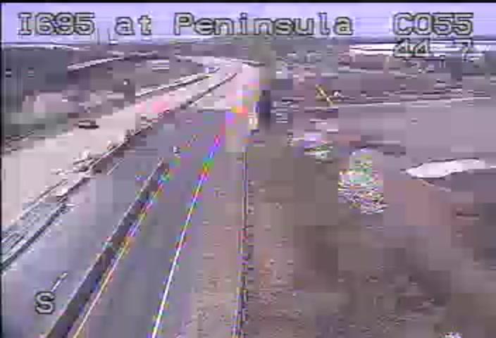
I-695 @ PENINSULA EXPY
Camera Direction: SOUTH. Source: SHA - Baltimore 21219
Cameras Closest To Broening Highway
1.80 Mi

2.94 Mi
There are no currently-available photos for this location.
The map above shows all services within about a two (2) mile radius.

Destination Travel

Closest Gas Stations
HIGH'S DAIRY STORE
6801 Broening Road • 1.45 miles
Store/Fuel Brand: High's
Closest EV Chargers
325 SOLLERS POINT ROAD
325 Sollers Point Road • 0.81 miles
CONNECTOR: Chademo
POWER: 50 KW @ 400 V
CURRENT: 125 Amp DC
BGE-SOLLERS POINT
325 Sollers Point Road • 0.85 miles
CONNECTOR: Chademo
POWER: 50 KW @ 400 V
CURRENT: 125 Amp DC
TPA MAIN OFFICE
6995 Bethlehem Boulevard • 1.61 miles
CONNECTOR: IEC62196Type1
POWER: 6 KW @ 208 V
CURRENT: 30 Amp AC1

Closest Fast Food
Fast food refers ONLY to quick-service and take-out diners. All restaurant types are shown on the map above.
HARVEY'S
3435 Dundalk Avenue • 1.33 miles
Journey to key destinations around and adjacent to Maryland!
Communities in this metro area include Baltimore, Edgewood, Columbia, Laurel, and Gaithersburg.
Individual toll maps for this region are listed below.
Communities in this metro area include Washington, Dc, Fairfax County, Virginia, Loundoun County, Virginia, Montgomery County, Maryland, and Prince George's County, Maryland.
Individual toll maps for this region are listed below.
Communities in this metro area include Wilmington, Middletown, Newark, and Carneys Point, New Jersey.
Individual toll maps for this region are listed below.
 Wm Preston Lane Jr Memorial Bridge ▹
 Fort McHenry Tunnel ▹
 Francis Scott Key Bridge ▹
 Baltimore Harbor Tunnel ▹
 Intercounty Connector MD 200 ▹
 Thomas J Hatem Memorial Bridge ▹
 Dulles Greenway ▹
 Delaware Memorial Bridge ▹
 Delaware Turnpike ▹
 State Route 1 ▹


