Map & services within two (2) miles
Interactive map shows available cameras, plus nearby fuel, food and lodging


See below for more about this area
Interactive map shows available cameras, plus nearby fuel, food and lodging
See below for more about this area
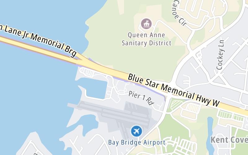
This is Exit 37 of the Wm Preston Lane Jr Memorial Bridge.
This junction is located in Stevensville. Chester is nearby.
This location is in the Washington Metro area; it also overlaps with the Baltimore area.
This location's approximate GPS Coordinates are 38.98039 x -76.32811.
Which directions can I travel from here?
From this junction, traffic can only enter going westbound. Traffic can only exit going eastbound.
◄ Back to Oceanic Road, about 5.8 miles away.
Which direction are tolls charged here?
Tolls are not charged or collected at this junction.
Above: Map image © TomTom Intl BVThe interactive map and lists on this page include key traveler services within two miles of this destination point.
You will find common services, including gas stations, truck stops, EV charging facilities, fast-food or family restaurants, and hotels. These are displayed on the interactive map as markers, which you can select for more information.
Current driving conditions and weather, along with a more complete list of key services, may be found below the map.

Mostly Cloudy
56°F / 13.3°C
Feels Like:
47°F / 8.1°C
Visibility
10 Mi / 16.1 Km
3-Hour Precip:
0.33 In / 0.8 Cm
Northwest
Winds (NW)
13.8 MPH / 22.2 KPH
Gusts:
21.9 MPH / 35.2 KPH
▸ Get the full forecast for This Location | The Washington Metro area
Conditions and forecasts provided in partnership with AccuWeather.

Weather provided in partnership with AccuWeather.

BAY BRIDGE @ GANTRY S-24
Camera Direction: EAST. Source: SHA - Baltimore 21666
Cameras Closest To Romancoke Road
0.40 Mi
1.47 Mi
1.95 Mi
2.66 Mi
2.66 Mi
There are no currently-available photos for this location.
The map above shows all services within about a two (2) mile radius.

Destination Travel

Closest Gas Stations
KENT ISLAND DEPOT
320 Romancoke Road • 0.47 miles
Store/Fuel Brand: BP
SHORE STOP
201 Romancoke Road • 0.48 miles
Store/Fuel Brand:
SHORE STOP
100 Main Street • 0.53 miles
Store/Fuel Brand:
LAST STOP
101 Duke Street • 0.96 miles
Store/Fuel Brand:
Closest EV Chargers
DPL - STEVENSVILLE PARK AND RIDE
111 Thompson Creek Road • 0.42 miles
CONNECTOR: Chademo
POWER: 50 KW @ 400 V
CURRENT: 125 Amp DC
111 THOMPSON CREEK ROAD
111 Thompson Creek Road • 0.42 miles
CONNECTOR: Chademo
POWER: 50 KW @ 400 V
CURRENT: 125 Amp DC
QUEEN ANNES COUNTY LIBRARY
200 Library Circle • 1.20 miles
CONNECTOR: IEC62196Type1
POWER: 9 KW @ 240 V
CURRENT: 40 Amp AC1
QUEEN ANNES COUNTY LIBRARY
200 Library Circle • 1.20 miles
CONNECTOR: IEC62196Type1
POWER: 7 KW @ 208 V
CURRENT: 35 Amp AC1

Closest Fast Food
Fast food refers ONLY to quick-service and take-out diners. All restaurant types are shown on the map above.
CHIPOTLE
373 Thompson Creek Mall • 0.84 miles
DOMINO'S
386 Thompson Creek Mall • 0.92 miles
MCDONALD'S
410 Thompson Creek Mall • 0.93 miles
STEVENSVILLE CRAB SHACK
116 Pier 1 Road • 1,724 feet
DUNKIN'
1132 Shopping Center Road • 1.61 miles
HARDEE'S
1157 Shopping Center Road • 1.64 miles
Journey to key destinations around and adjacent to Maryland!
Communities in this metro area include Baltimore, Edgewood, Columbia, Laurel, and Gaithersburg.
Individual toll maps for this region are listed below.
Communities in this metro area include Washington, Dc, Fairfax County, Virginia, Loundoun County, Virginia, Montgomery County, Maryland, and Prince George's County, Maryland.
Individual toll maps for this region are listed below.
Communities in this metro area include Wilmington, Middletown, Newark, and Carneys Point, New Jersey.
Individual toll maps for this region are listed below.
 Wm Preston Lane Jr Memorial Bridge ▹
 Fort McHenry Tunnel ▹
 Francis Scott Key Bridge ▹
 Baltimore Harbor Tunnel ▹
 Intercounty Connector MD 200 ▹
 Thomas J Hatem Memorial Bridge ▹
 Dulles Greenway ▹
 Delaware Memorial Bridge ▹
 Delaware Turnpike ▹
 State Route 1 ▹


