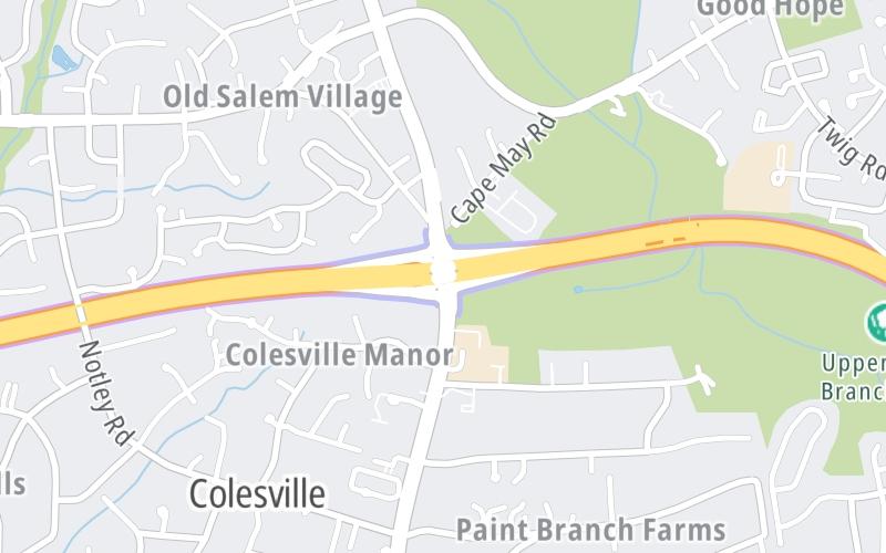
Map & services within two (2) miles
Interactive map shows available cameras, plus nearby fuel, food and lodging


See below for more about this area
Interactive map shows available cameras, plus nearby fuel, food and lodging
See below for more about this area
This is Exit 13 of the Intercounty Connector MD 200.
This junction is located in Colesville.
This location is in the Washington Metro area; it also overlaps with the Baltimore area.
This location's approximate GPS Coordinates are 39.08826 x -76.99953.
Which directions can I travel from here?
From this junction, traffic can enter traveling both westbound and eastbound. Traffic can also exit traveling both westbound and eastbound.
On to US 29/Columbia Pike, about 2.7 miles away ►
◄ Back to Layhill Road/MD 182, about 2.8 miles away.
Which direction are tolls charged here?
Tolls are not charged or collected at this junction.
Above: Map image © TomTom Intl BVThe interactive map and lists on this page include key traveler services within two miles of this destination point.
You will find common services, including gas stations, truck stops, EV charging facilities, fast-food or family restaurants, and hotels. These are displayed on the interactive map as markers, which you can select for more information.
Current driving conditions and weather, along with a more complete list of key services, may be found below the map.

Cloudy
50°F / 10.2°C
Feels Like:
46°F / 7.6°C
Visibility
4 Mi / 6.4 Km
3-Hour Precip:
0.19 In / 0.5 Cm
Northwest
Winds (NW)
6.3 MPH / 10.2 KPH
Gusts:
15.7 MPH / 25.2 KPH
▸ Get the full forecast for This Location | The Washington Metro area
Conditions and forecasts provided in partnership with AccuWeather.

Weather provided in partnership with AccuWeather.

ICC MD-200 W/O MD-650
Camera Direction: WEST. Source: SHA - Washington 20914
Cameras Closest To New Hampshire Avenue/MD 650
0.34 Mi
0.56 Mi
0.65 Mi
0.89 Mi
0.92 Mi
There are no currently-available photos for this location.
The map above shows all services within about a two (2) mile radius.

Destination Travel

Closest Gas Stations
GIANT FOODS
13490 New Hampshire Avenue • 0.77 miles
Store/Fuel Brand:
COLESVILLE BARBER SHOP
33 Randolph Road • 0.89 miles
Store/Fuel Brand: Exxon
SUNOCO
13335 New Hampshire Avenue • 0.91 miles
Store/Fuel Brand: Sunoco
COLESVILLE BP
13310 New Hampshire Avenue • 1.00 miles
Store/Fuel Brand: BP
Closest EV Chargers
RANDOLPH PLAZA
57 Randolph Road • 0.88 miles
CONNECTOR: IEC62196Type1
POWER: 6 KW @ 208 V
CURRENT: 30 Amp AC1

Closest Fast Food
Fast food refers ONLY to quick-service and take-out diners. All restaurant types are shown on the map above.
MCDONALD'S
504 East Randolph Road • 0.85 miles
WENDY'S
17 Vital Way • 0.93 miles
THE BAGELRY
36 Vital Way • 0.96 miles
BURGER KING
15421 New Hampshire Avenue • 1.47 miles
VOCELLI PIZZA
730 Cloverly Street • 1.49 miles
Journey to key destinations around and adjacent to Maryland!
Communities in this metro area include Baltimore, Edgewood, Columbia, Laurel, and Gaithersburg.
Individual toll maps for this region are listed below.
Communities in this metro area include Washington, Dc, Fairfax County, Virginia, Loundoun County, Virginia, Montgomery County, Maryland, and Prince George's County, Maryland.
Individual toll maps for this region are listed below.
Communities in this metro area include Wilmington, Middletown, Newark, and Carneys Point, New Jersey.
Individual toll maps for this region are listed below.
 Wm Preston Lane Jr Memorial Bridge ▹
 Fort McHenry Tunnel ▹
 Francis Scott Key Bridge ▹
 Baltimore Harbor Tunnel ▹
 Intercounty Connector MD 200 ▹
 Thomas J Hatem Memorial Bridge ▹
 Dulles Greenway ▹
 Delaware Memorial Bridge ▹
 Delaware Turnpike ▹
 State Route 1 ▹


