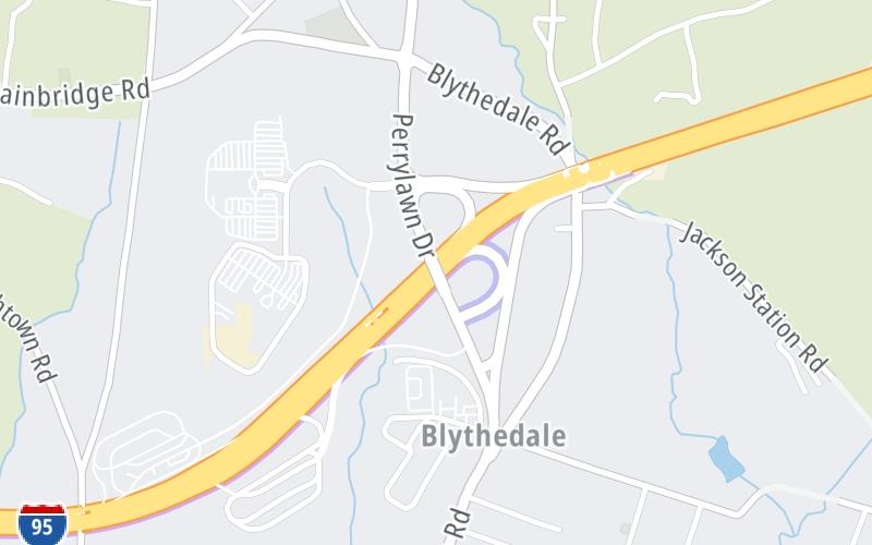
Map & services within two (2) miles
Interactive map shows available cameras, plus nearby fuel, food and lodging


See below for more about this area
Interactive map shows available cameras, plus nearby fuel, food and lodging
See below for more about this area
This is Exit 93 of the John F Kennedy Memorial Highway.
This junction is located in Perryville. Port Deposit is nearby. NOTE: Perryville.
This location is in the Baltimore area; it also overlaps with the Wilmington - Newark area.
This location's approximate GPS Coordinates are 39.59309 x -76.06635.
Which directions can I travel from here?
From this junction, traffic can enter traveling both southbound and northbound. Traffic can also exit traveling both southbound and northbound.
On to Chesapeake House Travel Plaza, about 3.8 miles away ►
◄ Back to MD 155 / Level Road, about 4.3 miles away.
Which direction are tolls charged here?
Tolls are not charged or collected at this junction.
Above: Photo by Turnpikes.comThe interactive map and lists on this page include key traveler services within two miles of this destination point.
You will find common services, including gas stations, truck stops, EV charging facilities, fast-food or family restaurants, and hotels. These are displayed on the interactive map as markers, which you can select for more information.
Current driving conditions and weather, along with a more complete list of key services, may be found below the map.

Light Rain
60°F / 15.4°C
Feels Like:
57°F / 14°C
Visibility
7 Mi / 11.3 Km
3-Hour Precip:
0.17 In / 0.4 Cm
West Northwest
Winds (WNW)
3.3 MPH / 5.3 KPH
Gusts:
10.3 MPH / 16.5 KPH
▸ Get the full forecast for This Location | The Baltimore area
Conditions and forecasts provided in partnership with AccuWeather.

Weather provided in partnership with AccuWeather.

US-40 @ HATEM BRDG PIER #18
Camera Direction: SOUTH. Source: SHA - Baltimore 21078
Cameras Closest To MD 222
2.68 Mi
3.01 Mi
3.02 Mi
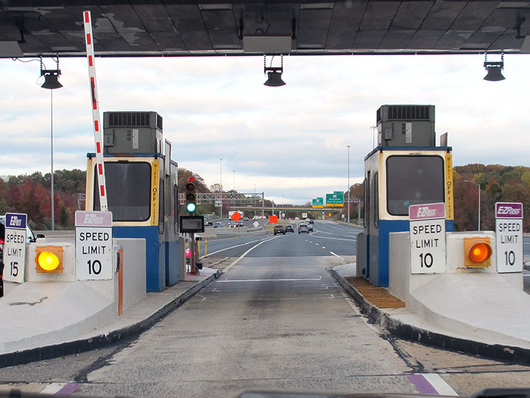
About this photo:
The northbound ramp, for the Port Deposit exit, off I-95 in Maryland, comes immediately after you pass through the Tydings Bridge Toll Plaza (now replaced by a gantry), on the JFK Memorial Highway. Because of this, exiting traffic is advised, on guide signs ahead of the plaza, to keep to the right.
Photo taken 10-29-2019
More Pictures Near MD 222


The map above shows all services within about a two (2) mile radius.

Destination Travel

Closest Gas Stations
ROYAL FARMS
1825 Perryville Road • 0.38 miles
Store/Fuel Brand: Royal Farms
ONE9
31 Heather Lane • 1,442 feet
Store/Fuel Brand:
ROYAL FARMS
5415 Pulaski Highway • 1.57 miles
Store/Fuel Brand: Royal Farms
Closest EV Chargers
HOLLYWOOD CASINO PERRYVILLE - SUPERCHARGER
1201 Chesapeake Overlook Parkway • 0.39 miles
CONNECTOR: Tesla
POWER: 250 KW @ 400 V
CURRENT: 625 Amp DC

Closest Fast Food
Fast food refers ONLY to quick-service and take-out diners. All restaurant types are shown on the map above.
DUNKIN'
1240 Chesapeake Overlook Parkway • 0.42 miles
PJ FRESH MARKETPLACE
31 Heather Lane • 1,429 feet
KFC
63 Heather Lane • 1,499 feet
DOMINO'S
5301 Pulaski Highway • 1.41 miles
Journey to key destinations around and adjacent to Maryland!
Communities in this metro area include Baltimore, Edgewood, Columbia, Laurel, and Gaithersburg.
Individual toll maps for this region are listed below.
Communities in this metro area include Washington, Dc, Fairfax County, Virginia, Loundoun County, Virginia, Montgomery County, Maryland, and Prince George's County, Maryland.
Individual toll maps for this region are listed below.
Communities in this metro area include Wilmington, Middletown, Newark, and Carneys Point, New Jersey.
Individual toll maps for this region are listed below.
 Wm Preston Lane Jr Memorial Bridge ▹
 Fort McHenry Tunnel ▹
 Francis Scott Key Bridge ▹
 Baltimore Harbor Tunnel ▹
 Intercounty Connector MD 200 ▹
 Thomas J Hatem Memorial Bridge ▹
 Dulles Greenway ▹
 Delaware Memorial Bridge ▹
 Delaware Turnpike ▹
 State Route 1 ▹


