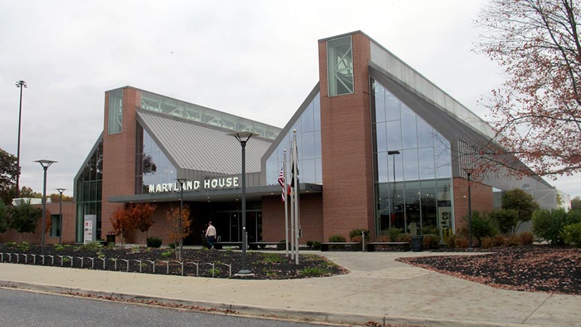
Interactive map shows available cameras, plus nearby fuel, food and lodging
See below for more about this area
This travel plaza is located in North East.
This location is in the Baltimore area.
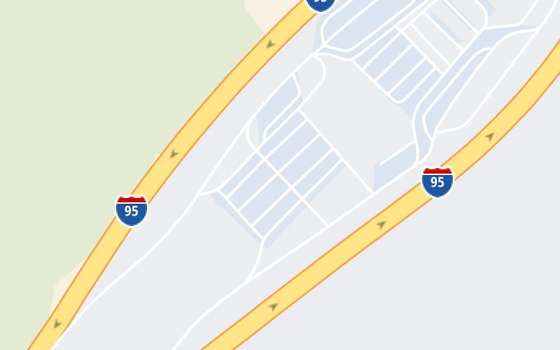
This location's approximate GPS Coordinates are 39.49664 x -76.23319.
On to MD 22 / Aberdeen Thruway, about 2.6 miles away ►
◄ Back to MD 543 / Riverside Parkway, about 1.9 miles away.
Above: Photo by Turnpikes.comThe interactive map and lists on this page include key traveler services within two miles of this destination point.
You will find common services, including gas stations, truck stops, EV charging facilities, fast-food or family restaurants, and hotels. These are displayed on the interactive map as markers, which you can select for more information.
Current driving conditions and weather, along with a more complete list of key services, may be found below the map.
Static map. Interactive map is above.Cloudy
64°F / 18°C
Feels Like:
65°F / 18.3°C
Visibility
9 Mi / 14.5 Km
3-Hour Precip:
0 In / 0.0 Cm
South Southwest
Winds (SSW)
6.2 MPH / 9.9 KPH
Gusts:
15 MPH / 24.2 KPH
▸ Get the full forecast for This Location | The Baltimore area
There is no currently-available traffic camera feed for this location.
The map above shows all services within about a two (2) mile radius.
Destination Travel
Closest Gas Stations
ROYAL FARMS
2692 Riverside Parkway • 1.32 miles
Store/Fuel Brand: Royal Farms
SHELL
4270 Philadelphia Road • 1.41 miles
Store/Fuel Brand: Shell
APLUS
1319 Riverside Parkway • 1.43 miles
Store/Fuel Brand: Sunoco
ALL IN ONE BP
1327 Policy Drive • 1.53 miles
Store/Fuel Brand: BP
Closest EV Chargers
TOWNEPLACE SUITES BY MARRIOTT EDGEWOOD ABERDEEN - TESLA DESTINATION
1357 Belcamp Road • 1.18 miles
CONNECTOR: Tesla
POWER: 7 KW @ 240 V
CURRENT: 30 Amp AC1
SHA - HARTFORD COUNTY
1400 Belcamp Road • 1.19 miles
CONNECTOR: IEC62196Type1
POWER: 6 KW @ 208 V
CURRENT: 30 Amp AC1
BEL AIR - TOBIN CROSSING, MD SUPERCHARGER
2692 Tobin Crossing • 1.33 miles
CONNECTOR: Tesla
POWER: 325 KW @ 400 V
CURRENT: 812 Amp DC
RIVERSIDE SHOPPING CENTER
1321 Riverside Parkway • 1.36 miles
CONNECTOR: IEC62196Type1CCS
POWER: 200 KW @ 1000 V
CURRENT: 200 Amp DC
Closest Fast Food
Fast food refers ONLY to quick-service and take-out diners. All restaurant types are shown on the map above.
TROPICAL SMOOTHIE CAFE
2804 Quicksilver Way • 1.32 miles
CHIPOTLE
2699 Tobin Xing • 1.36 miles
MCDONALD'S
1325 Riverside Parkway • 1.44 miles
BURGER KING
1325 Policy Drive • 1.53 miles
ARBY'S
1323 Policy Drive • 1.54 miles
PHILLIPS SEAFOOD
95 Jfk Memorial Highway • 395 feet
AUNTIE ANNE'S
• 419 feet
NATHAN'S FAMOUS
• 439 feet
Journey to key destinations around and adjacent to Maryland!
Communities in this metro area include Baltimore, Edgewood, Columbia, Laurel, and Gaithersburg.
Individual toll maps for this region are listed below.
Communities in this metro area include Washington, Dc, Fairfax County, Virginia, Loundoun County, Virginia, Montgomery County, Maryland, and Prince George's County, Maryland.
Individual toll maps for this region are listed below.
Communities in this metro area include Wilmington, Middletown, Newark, and Carneys Point, New Jersey.
Individual toll maps for this region are listed below.