John F Kennedy Memorial Highway At I–695 / Baltimore Beltway

Advertising
Advertising

Map & services within two (2) miles

Interactive map shows available cameras, plus nearby fuel, food and lodging

See below for more about this area

Advertising
Advertising

About This Location

I–695 / Baltimore Beltway

At A Glance

This is Exit 64/64A of the John F Kennedy Memorial Highway.

This junction is located in Rosedale. Rossville is nearby.

This location is in the Baltimore area.

Interactive Map Above

This location's approximate GPS Coordinates are 39.35044 x -76.49572.

Which directions can I travel from here?

From this junction, traffic can enter traveling both southbound and northbound. Traffic can also exit traveling both southbound and northbound.

On to MD 43 / White Marsh Blvd, about 3.3 miles away ►

Which direction are tolls charged here?

Tolls are not charged or collected at this junction.

View Map Travel Conditions

Above: Photo by Turnpikes.com

Using The POI Map

The interactive map and lists on this page include key traveler services within two miles of this destination point.

You will find common services, including gas stations, truck stops, EV charging facilities, fast-food or family restaurants, and hotels. These are displayed on the interactive map as markers, which you can select for more information.

Current driving conditions and weather, along with a more complete list of key services, may be found below the map.

View Map Weather

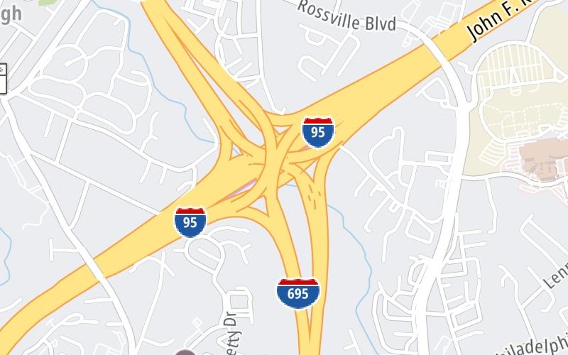
Static map of John F Kennedy Memorial Highway at I–695 / Baltimore Beltway
Static map. Interactive map is above.
Advertising
Advertising

Travel Conditions At I–695 / Baltimore Beltway

Current Weather And Visibility

  • 01 7 03
  • Cloudy

    67°F / 19.4°C

    Feels Like:

    65°F / 18.2°C

  • Visibility

    13 Mi / 20.9 Km

    3-Hour Precip:

    0 In / 0.0 Cm

  • South Southeast
    Winds (SSE)

    5 MPH / 8 KPH

    Gusts:

    10.7 MPH / 17.2 KPH

▸ Get the full forecast for This Location | The Baltimore area

Available Cameras

No camera feed …

There is no currently-available traffic camera feed for this location.

Advertising
Advertising

Travel Pictures

Pictures Around I–695 / Baltimore Beltway

About this photo:
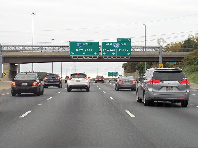
A heavy flow of traffic moves with synchronicity north of Baltimore, on I-95, just north of where the roadway becomes the JFK Memorial Highway. Exit 64 is at the interchange with I-695, and the multi-lane exit ramp for I-695 looms just over a rise, ahead on the right.

Photo taken 10-29-2019

More Pictures Near I–695 / Baltimore Beltway

Photo taken 10-29-2019
Advertising
Advertising

Closest Food, Gas, EV And Other Services Near I–695 / Baltimore Beltway

The map above shows all services within about a two (2) mile radius.

Hotels and destinations header

Hotels & Airports

Destination Travel

Fuel, EV and convenience store header

Gas & EV Charging

Closest Gas Stations

ROYAL FARMS

8803 Philadelphia Road • 0.91 miles

Store/Fuel Brand: Royal Farms

Shell

SMO

6321 Kenwood Avenue • 1.00 miles

Store/Fuel Brand: Shell

SAM'S CLUB

6410 Petrie Way Road • 1.07 miles

Store/Fuel Brand: Sam's Club

Exxon

EXXON

8605 Philadelphia Road • 1.11 miles

Store/Fuel Brand: Exxon

View Map

Closest EV Chargers

EV Smart

CCBC ESSEX COLLEGE

7201 Rossville Boulevard • 0.68 miles

CONNECTOR: Chademo
POWER: 150 KW @ 950 V
CURRENT: 158 Amp DC

SWTCH

7201 ROSSVILLE BOULEVARD

7201 Rossville Boulevard • 0.86 miles

CONNECTOR: Chademo
POWER: 50 KW @ 400 V
CURRENT: 125 Amp DC

Electrify America

WALMART

6420 Petrie Way Road • 0.99 miles

CONNECTOR: IEC62196Type1CCS
POWER: 150 KW @ 400 V
CURRENT: 375 Amp DC

Blink

OVERLOOK AT FRANKLIN SQUARE

8531 Upton Circle • 1,795 feet

CONNECTOR: IEC62196Type1
POWER: 6 KW @ 208 V
CURRENT: 30 Amp AC1

View Map

Coffee, snacks and dining header

Fast Food & Beverage

Closest Fast Food

Fast food refers ONLY to quick-service and take-out diners. All restaurant types are shown on the map above.

Popeyes

POPEYES

8669 Philadelphia Road • 0.94 miles

PUNJAB SUPERMARKET & HALAL MEAT

8767 Philadelphia Road • 0.94 miles

McDonald's

MCDONALD'S

6315 Kenwood Avenue • 0.97 miles

Wingstop

WINGSTOP

8633 Philadelphia Road • 0.97 miles

CHARLEYS CHEESESTEAKS

6420 Petrie Way Road • 1.00 miles

McDonald's

MCDONALD'S

6420 Petrie Way Road • 1.00 miles

DQ GRILL & CHILL

Golden Ring Road • 1.02 miles

Panda Express

PANDA EXPRESS

6419 Petrie Way Road • 1.03 miles

View Map

Discover Maryland Attractions

Advertising
Advertising

EXPLORE MARYLAND

Journey to key destinations around and adjacent to Maryland!

Map Of This Region ▹

Communities in this metro area include Washington, Dc, Fairfax County, Virginia, Loundoun County, Virginia, Montgomery County, Maryland, and Prince George's County, Maryland.

Individual toll maps for this region are listed below.

Map Of This Region ▹

Communities in this metro area include Wilmington, Middletown, Newark, and Carneys Point, New Jersey.

Individual toll maps for this region are listed below.

Advertising
Advertising
Turnpikes.com is proud to partner with the following: