John F Kennedy Memorial Highway At MD 543 / Riverside Parkway

Advertising
Advertising

Map & services within two (2) miles

Interactive map shows available cameras, plus nearby fuel, food and lodging

See below for more about this area

Advertising
Advertising

About This Location

MD 543 / Riverside Parkway

At A Glance

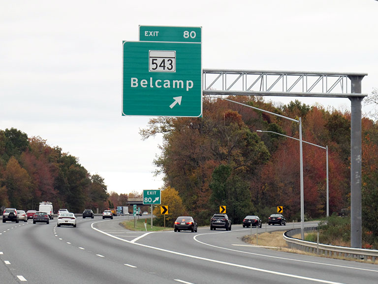
This is Exit 80 of the John F Kennedy Memorial Highway.

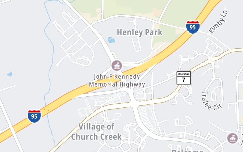
This junction is located in Belcamp. Bel Air South and Aberdeen are nearby. NOTE: Belcamp / South Bel Air.

This location is in the Baltimore area.

Interactive Map Above

This location's approximate GPS Coordinates are 39.48420 x -76.25136.

Which directions can I travel from here?

From this junction, traffic can enter traveling both southbound and northbound. Traffic can also exit traveling both southbound and northbound.

On to Maryland House Travel Plaza, about 1.9 miles away ►

◄ Back to MD 24 / Veterans Mem Hwy, about 3.6 miles away.

Which direction are tolls charged here?

Tolls are not charged or collected at this junction.

View Map Travel Conditions

Above: Photo by Turnpikes.com

Using The POI Map

The interactive map and lists on this page include key traveler services within two miles of this destination point.

You will find common services, including gas stations, truck stops, EV charging facilities, fast-food or family restaurants, and hotels. These are displayed on the interactive map as markers, which you can select for more information.

Current driving conditions and weather, along with a more complete list of key services, may be found below the map.

View Map Weather

Static map of John F Kennedy Memorial Highway at MD 543 / Riverside Parkway
Static map. Interactive map is above.
Advertising
Advertising

Travel Conditions At MD 543 / Riverside Parkway

Current Weather And Visibility

  • 12 7 03
  • Cloudy

    64°F / 18°C

    Feels Like:

    65°F / 18.2°C

  • Visibility

    10 Mi / 16.1 Km

    3-Hour Precip:

    0 In / 0.0 Cm

  • South Southwest
    Winds (SSW)

    5.6 MPH / 9 KPH

    Gusts:

    13 MPH / 20.9 KPH

▸ Get the full forecast for This Location | The Baltimore area

Available Cameras

No camera feed …

There is no currently-available traffic camera feed for this location.

Advertising
Advertising

Travel Pictures

Pictures Around MD 543 / Riverside Parkway

About this photo:
Northbound traffic exits at Riverside Parkway (MD 543) in Aberdeen, Maryland, just north of Baltimore. MD 543 also leads into nearby Belcamp, Bel Air and Bel Air South, which sits adjacent to the Cedar Lane Regional Park, and in between the Stoney Demonstration State Forest and the Bynum Run Conservation Area.

Photo taken 10-29-2019

More Pictures Near MD 543 / Riverside Parkway

Photo taken 10-29-2019
Advertising
Advertising

Closest Food, Gas, EV And Other Services Near MD 543 / Riverside Parkway

The map above shows all services within about a two (2) mile radius.

Hotels and destinations header

Hotels & Airports

Destination Travel

Fuel, EV and convenience store header

Gas & EV Charging

Closest Gas Stations

ROYAL FARMS

2692 Riverside Parkway • 0.40 miles

Store/Fuel Brand: Royal Farms

BP

ALL IN ONE BP

1327 Policy Drive • 0.44 miles

Store/Fuel Brand: BP

Shell

SHELL

4270 Philadelphia Road • 1,039 feet

Store/Fuel Brand: Shell

Sunoco

APLUS

1319 Riverside Parkway • 1,782 feet

Store/Fuel Brand: Sunoco

View Map

Closest EV Chargers

Tesla

BEL AIR - TOBIN CROSSING, MD SUPERCHARGER

2692 Tobin Crossing • 0.43 miles

CONNECTOR: Tesla
POWER: 325 KW @ 400 V
CURRENT: 812 Amp DC

ChargePoint

CHARGEPOINT

4150 Philadelphia Road • 0.43 miles

CONNECTOR: IEC62196Type1
POWER: 6 KW @ 240 V
CURRENT: 27 Amp AC1

ChargePoint

CHARGEPOINT

4160 Philadelphia Road • 0.43 miles

CONNECTOR: IEC62196Type1
POWER: 6 KW @ 240 V
CURRENT: 27 Amp AC1

Blink

SHA - HARTFORD COUNTY

1400 Belcamp Road • 1,156 feet

CONNECTOR: IEC62196Type1
POWER: 6 KW @ 208 V
CURRENT: 30 Amp AC1

View Map

Coffee, snacks and dining header

Fast Food & Beverage

Closest Fast Food

Fast food refers ONLY to quick-service and take-out diners. All restaurant types are shown on the map above.

McDonald's

MCDONALD'S

1325 Riverside Parkway • 0.38 miles

TROPICAL SMOOTHIE CAFE

2804 Quicksilver Way • 0.40 miles

BURGER KING

BURGER KING

1325 Policy Drive • 0.45 miles

Arby's

ARBY'S

1323 Policy Drive • 0.48 miles

Chipotle

CHIPOTLE

2699 Tobin Xing • 0.49 miles

BOULEVARD BISTRO

111 Bata Boulevard • 1.35 miles

PHILLIPS SEAFOOD

95 Jfk Memorial Highway • 1.37 miles

Auntie Anne's

AUNTIE ANNE'S

• 1.38 miles

View Map

Discover Maryland Attractions

Advertising
Advertising

EXPLORE MARYLAND

Journey to key destinations around and adjacent to Maryland!

Map Of This Region ▹

Communities in this metro area include Washington, Dc, Fairfax County, Virginia, Loundoun County, Virginia, Montgomery County, Maryland, and Prince George's County, Maryland.

Individual toll maps for this region are listed below.

Map Of This Region ▹

Communities in this metro area include Wilmington, Middletown, Newark, and Carneys Point, New Jersey.

Individual toll maps for this region are listed below.

Advertising
Advertising
Turnpikes.com is proud to partner with the following: