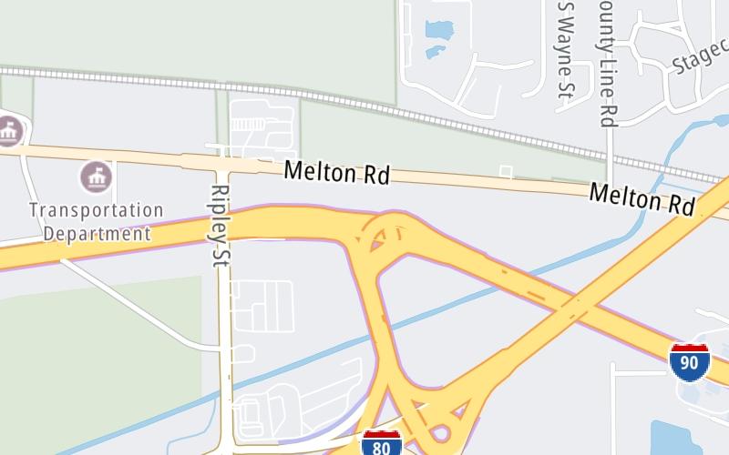
Map & services within two (2) miles
Interactive map shows available cameras, plus nearby fuel, food and lodging


See below for more about this area
Interactive map shows available cameras, plus nearby fuel, food and lodging
See below for more about this area
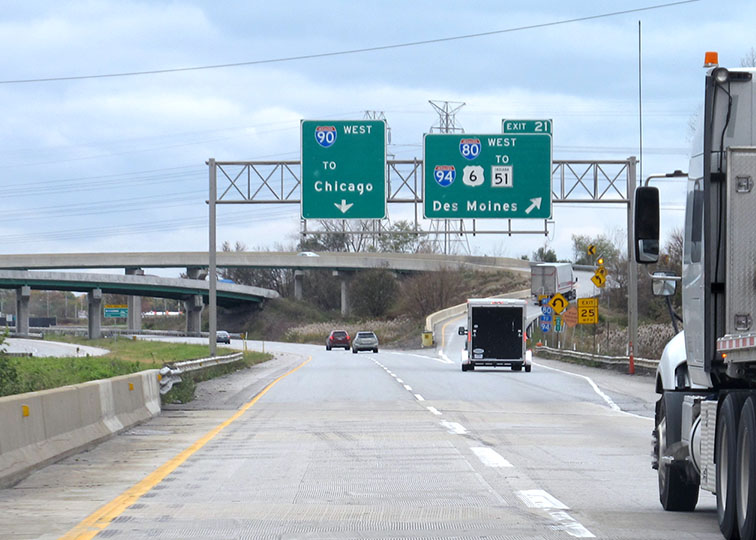
This is Exit 21 of the Indiana Toll Road.
This junction is located in Gary. Lake Station is nearby. NOTE: Cameras are at I-94/I-80 Interchange.
This location is in the Northern Indiana area; it also overlaps with the Chicagoland - Northwestern Indiana area.
This location's approximate GPS Coordinates are 41.59294 x -87.23384.
Which directions can I travel from here?
From this junction, traffic can enter traveling both westbound and eastbound. Traffic can also exit traveling both westbound and eastbound.
On to J.T. McCutcheon Travel Plaza, about 1.1 miles away ►
◄ Back to I–65 / Gary East, about 3.9 miles away.
This location also connects with Illinois.
▹ The Indiana Toll Road and the Tri State Tollway connect here.
Which direction are tolls charged here?
The interactive map and lists on this page include key traveler services within two miles of this destination point.
You will find common services, including gas stations, truck stops, EV charging facilities, fast-food or family restaurants, and hotels. These are displayed on the interactive map as markers, which you can select for more information.
Current driving conditions and weather, along with a more complete list of key services, may be found below the map.

Mostly Cloudy
36°F / 2.4°C
Feels Like:
30°F / -0.8°C
Visibility
4 Mi / 6.4 Km
3-Hour Precip:
0.02 In / 0.0 Cm
Northwest
Winds (NW)
6.3 MPH / 10.1 KPH
Gusts:
12.6 MPH / 20.2 KPH
▸ Get the full forecast for This Location | The Northern Indiana area
Conditions and forecasts provided in partnership with AccuWeather.

Weather provided in partnership with AccuWeather.
There is no currently-available traffic camera feed for this location.
About this photo:
Westbound drivers on the Indiana Toll Road approach Exit 21, where I-80 forks from the ITR, and to I-94 and the Tri State Tollway. Photo taken November 2, 2019.
Photo taken 11-02-2019
More Pictures Near I–80 / I–94


The map above shows all services within about a two (2) mile radius.

Destination Travel

Closest Gas Stations
PILOT TRAVEL PLAZA - MR. FUEL
1235 Ripley Street • 0.42 miles
Store/Fuel Brand: Pilot Travel Center
FLYING J
1401 Ripley Street • 0.50 miles
Store/Fuel Brand: Flying J
BP
1201 Ripley Street • 1,739 feet
Store/Fuel Brand: BP
BP STATION
Ripley Street • 1,802 feet
Store/Fuel Brand: BP
Closest EV Chargers
PORTAGE - GEORGE ADE TRAVEL PLAZA, IN SUPERCHARGER
Indiana Toll Road • 0.92 miles
CONNECTOR: Tesla
POWER: 250 KW @ 400 V
CURRENT: 625 Amp DC
PORTAGE - JOHN T MCCUTCHEON TRAVEL PLAZA, IN SUPERCHARGER
Indiana Toll Road • 0.95 miles
CONNECTOR: Tesla
POWER: 250 KW @ 400 V
CURRENT: 625 Amp DC

Closest Fast Food
Fast food refers ONLY to quick-service and take-out diners. All restaurant types are shown on the map above.
CINNABON
1401 Ripley Street • 0.53 miles
DEPOT HOT DOGS
5016 Melton Road • 0.64 miles
HARDEE'S
• 0.93 miles
HARDEE'S
• 0.95 miles
POPEYES
1201 Ripley Street • 1,739 feet
BURGER KING
2203 Ripley Street • 1.11 miles
LONG JOHN SILVER'S
3446 Central Avenue • 1.33 miles
DAIRY QUEEN
2433 Ripley Street • 1.34 miles
Journey to key destinations around and adjacent to Indiana!
Communities in this metro area include Gary, South Bend, Elkhart, Portage, and Fremont.
Individual toll maps for this region are listed below.
Communities in this metro area include Chicago, Aurora, Oak Lawn, Des Plaines, Waukegan, Highland Park, Gary, Indiana, Schaumburg, Naperville, Oak Brook, and Joliet.
Individual toll maps for this region are listed below.
Communities in this metro area include Louisville and Jeffersonville, Indiana.
Individual toll maps for this region are listed below.
Communities in this metro area include Toledo, Perrysburg, Maumee, Montpelier, and Wauseon.
Individual toll maps for this region are listed below.

Communities in this metro area include Detroit, Grosse Ile, Ann Arbor, Pontiac, and Lansing.
Individual toll maps for this region are listed below.

 Indiana Toll Road ▹
 Chicago Skyway ▹
 Tri State Tollway ▹
 Ohio Turnpike ▹
 Cline Avenue Bridge ▹
 Jane Addams Memorial Tollway ▹
 Ronald Reagan Memorial Tollway ▹
 Veterans Memorial Tollway ▹
 Houbolt Road Extension ▹
 Lewis And Clark Bridge ▹
 Abraham Lincoln Bridge ▹
 Ambassador Bridge ▹
 Detroit Windsor Tunnel ▹


