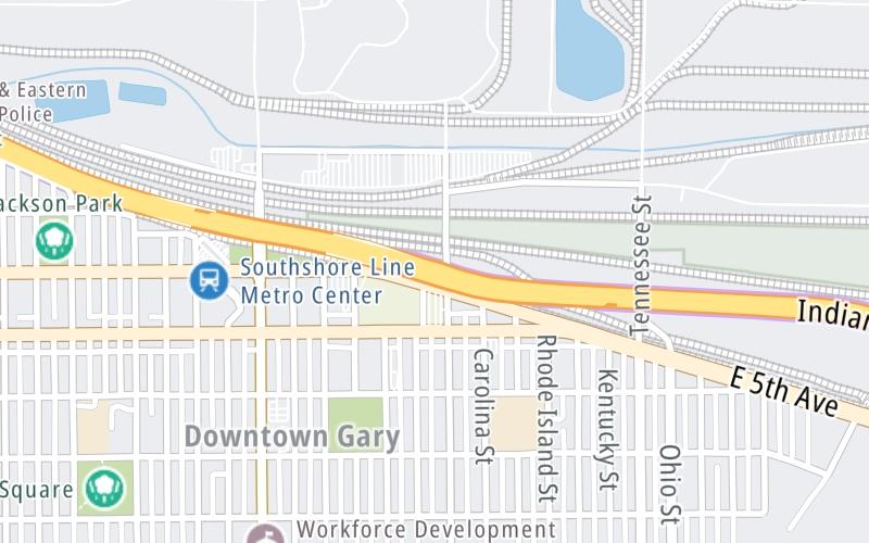
Map & services within two (2) miles
Interactive map shows available cameras, plus nearby fuel, food and lodging


See below for more about this area
Interactive map shows available cameras, plus nearby fuel, food and lodging
See below for more about this area
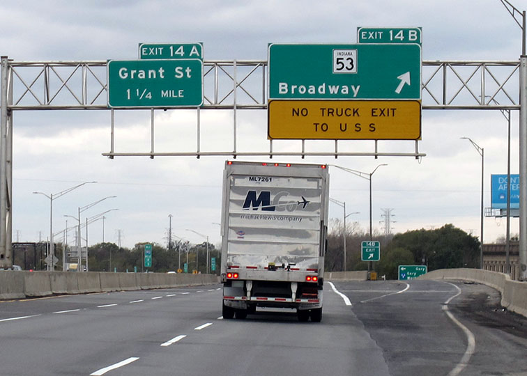
This is Exit 14B of the Indiana Toll Road.
This junction is located in Gary.
This location is in the Northern Indiana area; it also overlaps with the Chicagoland - Northwestern Indiana area.
This location's approximate GPS Coordinates are 41.60384 x -87.33026.
Which directions can I travel from here?
From this junction, traffic can enter traveling both westbound and eastbound. Traffic can also exit traveling both westbound and eastbound.
On to I–65 / Gary East, about 2.4 miles away ►
◄ Back to Grant St / Buchanan St, about 1.0 mile away.
Which direction are tolls charged here?
Tolls are not charged or collected at this junction.
Above: Photo by Turnpikes.comThe interactive map and lists on this page include key traveler services within two miles of this destination point.
You will find common services, including gas stations, truck stops, EV charging facilities, fast-food or family restaurants, and hotels. These are displayed on the interactive map as markers, which you can select for more information.
Current driving conditions and weather, along with a more complete list of key services, may be found below the map.

Cloudy
38°F / 3.5°C
Feels Like:
29°F / -1.6°C
Visibility
10 Mi / 16.1 Km
3-Hour Precip:
0 In / 0.0 Cm
North
Winds (N)
13.8 MPH / 22.2 KPH
Gusts:
20.7 MPH / 33.3 KPH
▸ Get the full forecast for This Location | The Northern Indiana area
Conditions and forecasts provided in partnership with AccuWeather.

Weather provided in partnership with AccuWeather.
There is no currently-available traffic camera feed for this location.
About this photo:
Guide signs direct traffic for Exit 14B, to Broadway in Gary, from the westbound lanes of the Indiana Toll Road. Photo taken November 2, 2019.
Photo taken 11-02-2019
More Pictures Near Broadway / US 12 / US 20


The map above shows all services within about a two (2) mile radius.

Destination Travel

Closest Gas Stations
CLARK
901 East 5th Avenue • 1,525 feet
Store/Fuel Brand: Clark
CITGO
901 East 5th Avenue • 1,525 feet
Store/Fuel Brand: Citgo
CITGO
1501 Broadway • 1.16 miles
Store/Fuel Brand: Citgo
CLARK
2301 East 15th Avenue • 1.57 miles
Store/Fuel Brand: Clark
Closest EV Chargers
No EV charging stations nearby.

Closest Fast Food
Fast food refers ONLY to quick-service and take-out diners. All restaurant types are shown on the map above.
POPEYES
1080 Broadway • 0.90 miles
RALLY'S
910 West 5th Avenue • 0.97 miles
LITTLE CAESARS
1316 Broadway • 1.03 miles
WHITE CASTLE
1304 Broadway • 1.04 miles
CHURCH'S CHICKEN
1409 Broadway • 1.09 miles
MCDONALD'S
1527 West 5th Avenue • 1.35 miles
Journey to key destinations around and adjacent to Indiana!
Communities in this metro area include Gary, South Bend, Elkhart, Portage, and Fremont.
Individual toll maps for this region are listed below.
Communities in this metro area include Chicago, Aurora, Oak Lawn, Des Plaines, Waukegan, Highland Park, Gary, Indiana, Schaumburg, Naperville, Oak Brook, and Joliet.
Individual toll maps for this region are listed below.
Communities in this metro area include Louisville and Jeffersonville, Indiana.
Individual toll maps for this region are listed below.
Communities in this metro area include Toledo, Perrysburg, Maumee, Montpelier, and Wauseon.
Individual toll maps for this region are listed below.

Communities in this metro area include Detroit, Grosse Ile, Ann Arbor, Pontiac, and Lansing.
Individual toll maps for this region are listed below.

 Indiana Toll Road ▹
 Chicago Skyway ▹
 Tri State Tollway ▹
 Ohio Turnpike ▹
 Cline Avenue Bridge ▹
 Jane Addams Memorial Tollway ▹
 Ronald Reagan Memorial Tollway ▹
 Veterans Memorial Tollway ▹
 Houbolt Road Extension ▹
 Lewis And Clark Bridge ▹
 Abraham Lincoln Bridge ▹
 Ambassador Bridge ▹
 Detroit Windsor Tunnel ▹


