Map & services within two (2) miles
Interactive map shows available cameras, plus nearby fuel, food and lodging


See below for more about this area
Interactive map shows available cameras, plus nearby fuel, food and lodging
See below for more about this area
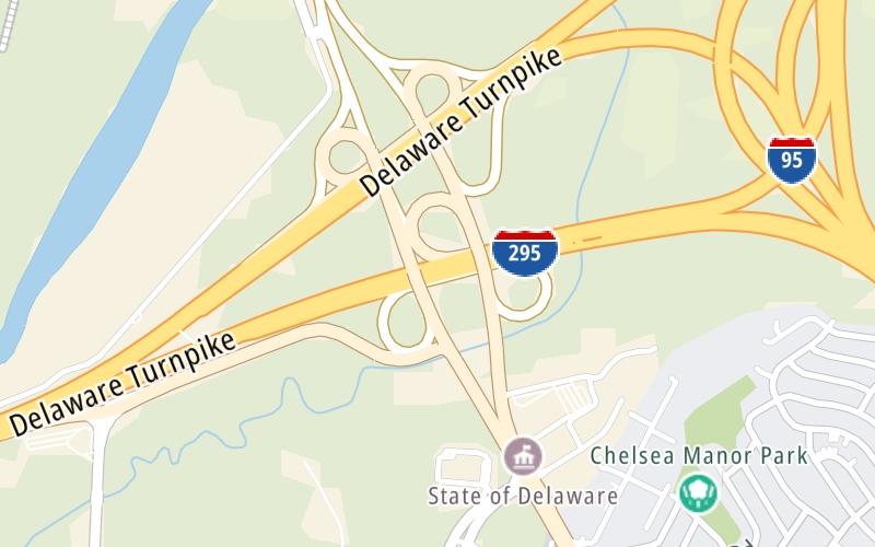
This is Exit 5 of the Delaware Turnpike.
This junction is located in New Castle. Newport is nearby.
This location is in the Wilmington - Newark area; it also overlaps with the South Jersey - Philadelphia area.
This location's approximate GPS Coordinates are 39.69992 x -75.60305.
Which directions can I travel from here?
From this junction, traffic can enter traveling both southbound and northbound. Traffic can also exit traveling both southbound and northbound.
On to US 13 / N Dupont Pkwy, about 1.5 miles away ►
◄ Back to SR 1 / SR 7 / SR 58 / Christian Crossing, about 3.2 miles away.
This location also connects with New Jersey.
Which direction are tolls charged here?
Tolls are not charged or collected at this junction.
Above: Photo by Turnpikes.comThe interactive map and lists on this page include key traveler services within two miles of this destination point.
You will find common services, including gas stations, truck stops, EV charging facilities, fast-food or family restaurants, and hotels. These are displayed on the interactive map as markers, which you can select for more information.
Current driving conditions and weather, along with a more complete list of key services, may be found below the map.

Sunny
45°F / 7.2°C
Feels Like:
33°F / 0.5°C
Visibility
10 Mi / 16.1 Km
3-Hour Precip:
0 In / 0.0 Cm
Northwest
Winds (NW)
18.4 MPH / 29.6 KPH
Gusts:
26.5 MPH / 42.6 KPH
▸ Get the full forecast for This Location | The Wilmington - Newark area
Conditions and forecasts provided in partnership with AccuWeather.

Weather provided in partnership with AccuWeather.
There is no currently-available traffic camera feed for this location.
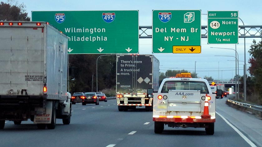
About this photo:
Northbound traffic at dusk on the Delaware Turnpike, about a quarter-mile from the Newport exit, Exit 5B. Photo taken October 29, 2019.
Photo taken 10-29-2019
The map above shows all services within about a two (2) mile radius.

Destination Travel

Closest Gas Stations
WAWA
7 East Commons Boulevard • 0.44 miles
Store/Fuel Brand: Wawa
WASTE MANAGEMENT - WILMINGTON
300 Harvey Drive • 0.98 miles
Store/Fuel Brand:
CHELSEA BP
1 Jay Drive • 1.02 miles
Store/Fuel Brand: BP
NEWPORT EXXON
20 North James Street • 1.04 miles
Store/Fuel Brand: Exxon
Closest EV Chargers
GOVERNMENT CENTER
87 Reads Way • 1.10 miles
CONNECTOR: IEC62196Type1
POWER: 6 KW @ 208 V
CURRENT: 30 Amp AC1
DELAWARE ARMY AVIATION SUPPORT FACILITY
33 Corporate Circle • 1.37 miles
CONNECTOR: IEC62196Type1
POWER: 6 KW @ 208 V
CURRENT: 30 Amp AC1
BIDEN NG/RC
1 Dales Way • 1.39 miles
CONNECTOR: IEC62196Type1
POWER: 6 KW @ 208 V
CURRENT: 30 Amp AC1

Closest Fast Food
Fast food refers ONLY to quick-service and take-out diners. All restaurant types are shown on the map above.
CAPRIOTTI'S
708 West Basin Road • 0.99 miles
DAIRY PALACE
2 West Basin Road • 1.06 miles
POPEYES
1505 North Dupont Highway • 1.28 miles
CHECKERS
1503 North Dupont Highway • 1.30 miles
LITTLE CAESARS
1400 North Dupont Highway • 1.36 miles
BURGER KING
1530 North Dupont Highway • 1.37 miles
MCDONALD'S
700 North Dupont Highway • 1.39 miles
ITALIAN KITCHEN
320 North Dupont Highway • 1.49 miles
Journey to key destinations around and adjacent to Delaware!
Communities in this metro area include Wilmington, Middletown, Newark, and Carneys Point, New Jersey.
Individual toll maps for this region are listed below.
Communities in this metro area include Camden, Dover, Dover Afb, and Smyrna.
Individual toll maps for this region are listed below.
Communities in this metro area include Camden, Burlington, Palmyra, Pennsauken, Cherry Hill, Gloucester City, Trenton, Wilmington, Delaware, Philadelphia, Pennsylvania, Tacony, Pennsylvania, and Bristol, Pennsylvania.
Individual toll maps for this region are listed below.

Roads Within Region
Communities in this metro area include Philadelphia, King Of Prussia, Valley Forge, West Chester, Bristol, Burlington, New Jersey, Morrisville, Trenton, New Jersey, Palmyra, New Jersey, Wilmington, Delaware, and Camden, New Jersey.
Individual toll maps for this region are listed below.

Roads Within Region

 Delaware Memorial Bridge ▹
 Delaware Turnpike ▹
 State Route 1 ▹
 US 301 ▹
 John F Kennedy Memorial Highway ▹
 Atlantic City Expressway ▹
 Garden State Parkway ▹
 New Jersey Turnpike ▹
 Pennsylvania Turnpike ▹
 Benjamin Franklin Bridge ▹
 Walt Whitman Bridge ▹
 Commodore Barry Bridge ▹
 Betsy Ross Bridge ▹
 Scudder Falls Toll Bridge ▹
 Trenton Morrisville Toll Bridge ▹
 Tacony Palmyra Bridge ▹
 Burlington Bristol Bridge ▹


