Interactive map shows available cameras, plus nearby fuel, food and lodging
See below for more about this area
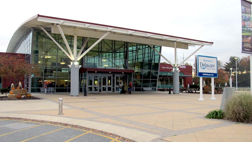
This travel plaza is located in Newark. Middletown is nearby. NOTE: Includes Biden Welcome Center.
This location is in the Wilmington - Newark area.
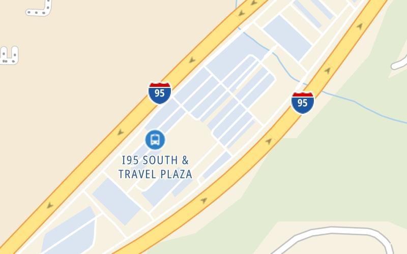
This location's approximate GPS Coordinates are 39.66236 x -75.69092.
On to SR 273 / Christiana Road, about 1.3 miles away ►
◄ Back to SR 896 / S College Ave, about 3.1 miles away.
Above: Photo by Turnpikes.comThe interactive map and lists on this page include key traveler services within two miles of this destination point.
You will find common services, including gas stations, truck stops, EV charging facilities, fast-food or family restaurants, and hotels. These are displayed on the interactive map as markers, which you can select for more information.
Current driving conditions and weather, along with a more complete list of key services, may be found below the map.
Static map. Interactive map is above.Cloudy
68°F / 19.8°C
Feels Like:
65°F / 18.1°C
Visibility
2 Mi / 3.2 Km
3-Hour Precip:
0 In / 0.0 Cm
South Southeast
Winds (SSE)
4.3 MPH / 7 KPH
Gusts:
10.3 MPH / 16.6 KPH
▸ Get the full forecast for This Location | The Wilmington - Newark area
There is no currently-available traffic camera feed for this location.
About this photo:
Exterior view of the north, and main, entrance of the Biden Welcome Center, located on the Delaware Turnpike. Photo taken October 29, 2019 by TurnpikeInfo.com.
Photo taken 10-29-2019
The map above shows all services within about a two (2) mile radius.
Destination Travel
Closest Gas Stations
NEWARK FUELS
1147 Christiana Road • 1.05 miles
Store/Fuel Brand:
DASH IN FOOD STORE
1148 Christiana Road • 1.08 miles
Store/Fuel Brand: Shell
UNIVERSITY PLAZA SERVICE CENTER
300 Chapman Road • 1.12 miles
Store/Fuel Brand: Exxon
OGLETOWN LIBERTY
728 East Chestnut Hill Road • 1.12 miles
Store/Fuel Brand: Liberty
Closest EV Chargers
DELDOT CONSTRUCTION OFFICE
80 Chapman Road • 1,429 feet
CONNECTOR: IEC62196Type1
POWER: 6 KW @ 208 V
CURRENT: 30 Amp AC1
WAWA - SUPERCHARGER SUPERCHARGER
970 Christiana Road • 1.28 miles
CONNECTOR: Tesla
POWER: 250 KW @ 400 V
CURRENT: 625 Amp DC
CHARGEPOINT
401 Eagle Run Road • 1.30 miles
CONNECTOR: IEC62196Type1
POWER: 12 KW @ 240 V
CURRENT: 50 Amp AC1
NEWARK, DE SUPERCHARGER
530 JFK Memorial Highway • 466 feet
CONNECTOR: Tesla
POWER: 150 KW @ 400 V
CURRENT: 375 Amp DC
Closest Fast Food
Fast food refers ONLY to quick-service and take-out diners. All restaurant types are shown on the map above.
DOMINO'S
20 Salem Village Square • 0.46 miles
AJA SNACKS BY ARE HANDMADE
61 West Kyla Marie Drive • 1,379 feet
POPEYES
80 McIntosh Plaza • 1.03 miles
7-ELEVEN
699 East Chestnut Hill Road • 1.05 miles
GYRO KEBAB HOUSE
1142 Christiana Road • 1.07 miles
WENDY'S
90 University Plaza • 1.18 miles
BOSTON MARKET
300 University Plaza • 1.27 miles
WAWA
970 Christiana Rd • 1.29 miles
Journey to key destinations around and adjacent to Delaware!
Communities in this metro area include Wilmington, Middletown, Newark, and Carneys Point, New Jersey.
Individual toll maps for this region are listed below.
Communities in this metro area include Camden, Dover, Dover Afb, and Smyrna.
Individual toll maps for this region are listed below.
Communities in this metro area include Camden, Burlington, Palmyra, Pennsauken, Cherry Hill, Gloucester City, Trenton, Wilmington, Delaware, Philadelphia, Pennsylvania, Tacony, Pennsylvania, and Bristol, Pennsylvania.
Individual toll maps for this region are listed below.
Roads Within Region
Communities in this metro area include Philadelphia, King Of Prussia, Valley Forge, West Chester, Bristol, Burlington, New Jersey, Morrisville, Trenton, New Jersey, Palmyra, New Jersey, Wilmington, Delaware, and Camden, New Jersey.
Individual toll maps for this region are listed below.
Roads Within Region