California Traffic And Weather

Right Now In Sacramento

Travel Conditions California's Capital Area

Current Weather And Visibility

2:39 am Local Time

  • 02 7 10
  • Partly Cloudy

    68°F / 20.3°C

    Feels Like:

    67°F / 19.5°C

  • Visibility

    10 Mi / 16.1 Km

    3-Hour Precip:

    0 In / 0.0 Cm

  • North Northeast
    Winds (NNE)

    1.7 MPH / 2.8 KPH

    Gusts:

    2.9 MPH / 4.6 KPH

Conditions and forecasts provided in partnership with AccuWeather.

AccuWeather logo

Weather provided in partnership with AccuWeather.

AccuWeather logo

Key Metro Areas In California
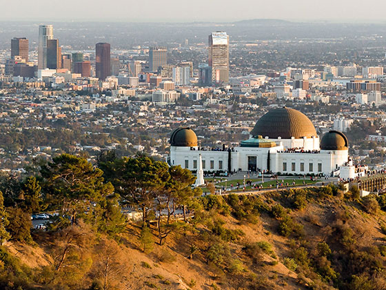
Regional photo of Greater Los Angeles

Greater Los Angeles

Includes the following communities: Los Angeles, Long Beach, Irvine, San Juan Capistrano, and Santa Ana.

Regional photo of San Francisco Bay Area

San Francisco Bay Area

Includes the following communities: San Francisco, San Jose, Sausalito, and Menlo Park.

Regional photo of San Diego

San Diego

Includes the following communities: San Diego, Chula Vista, and Tijuana, Mexico.

Weather radar and forecasts for all California's metro areas follow the jump. Regional and roadway weather include traffic cameras to view real-time driving conditions.

Your capital city driving conditions and forecast follow the jump. You will also find an extended forecast, for extended travel planning in California's capital.

Capital Forecast ▾Metro Areas ▾

Advertising
Advertising

Conditions On California Roads

California Radar & Satellite

NOAA composite satellite & weather radar imagery.

Images from GOES-West Pacific Southwest Sector. Sequence may take a moment to initialize.

  • GOES 18: GOES-West Pacific Southwest Sector
  • GOES 18: GOES-West Pacific Southwest Sector
  • GOES 18: GOES-West Pacific Southwest Sector
  • GOES 18: GOES-West Pacific Southwest Sector
  • GOES 18: GOES-West Pacific Southwest Sector
  • GOES 18: GOES-West Pacific Southwest Sector
  • GOES 18: GOES-West Pacific Southwest Sector
  • GOES 18: GOES-West Pacific Southwest Sector

Key Roads By Region

Select any metro area for regional weather. Select individual roads to view weather for that road by itself.

Note that state-wide toll roads will cross multiple regions; therefore, you may see multiple instances of the same road across all regions.

Regional photo of Greater Los Angeles

Greater Los Angeles

Regional photo of San Diego

San Diego

Roads Within Region

South Bay Expressway ▹

Advertising
Advertising

Driving Around California's Capital, Sacramento

12-Hour Forecast

2:39 am Local Time

Conditions and forecasts provided in partnership with AccuWeather.

AccuWeather logo

Weather provided in partnership with AccuWeather.

AccuWeather logo
Advertising
Advertising

Extended Forecast For Sacramento

Ten (10) Day Travel Planner

Go Online Before You Go On The Road!®

Conditions and forecasts provided in partnership with AccuWeather.

AccuWeather logo

Weather provided in partnership with AccuWeather.

AccuWeather logo
Advertising
Advertising

EXPLORE CALIFORNIA

Journey to key destinations around and adjacent to California!

Map Of This Region ▹

Communities in this metro area include Los Angeles, Long Beach, Irvine, San Juan Capistrano, and Santa Ana.

Individual toll maps for this region are listed below.

Map Of This Region ▹

Communities in this metro area include San Diego, Chula Vista, and Tijuana, Mexico.

Individual toll maps for this region are listed below.

Advertising
Advertising
Turnpikes.com is proud to partner with the following: