This map of CA 261 displays markers for exits and tolling points, which you can select to get a close-up map of that point of interest or location.
The points-of-interest shown on this map are also listed below, ordered from south to north.
See below for more comprehensive information about CA 261
This local toll road serves Irvine.
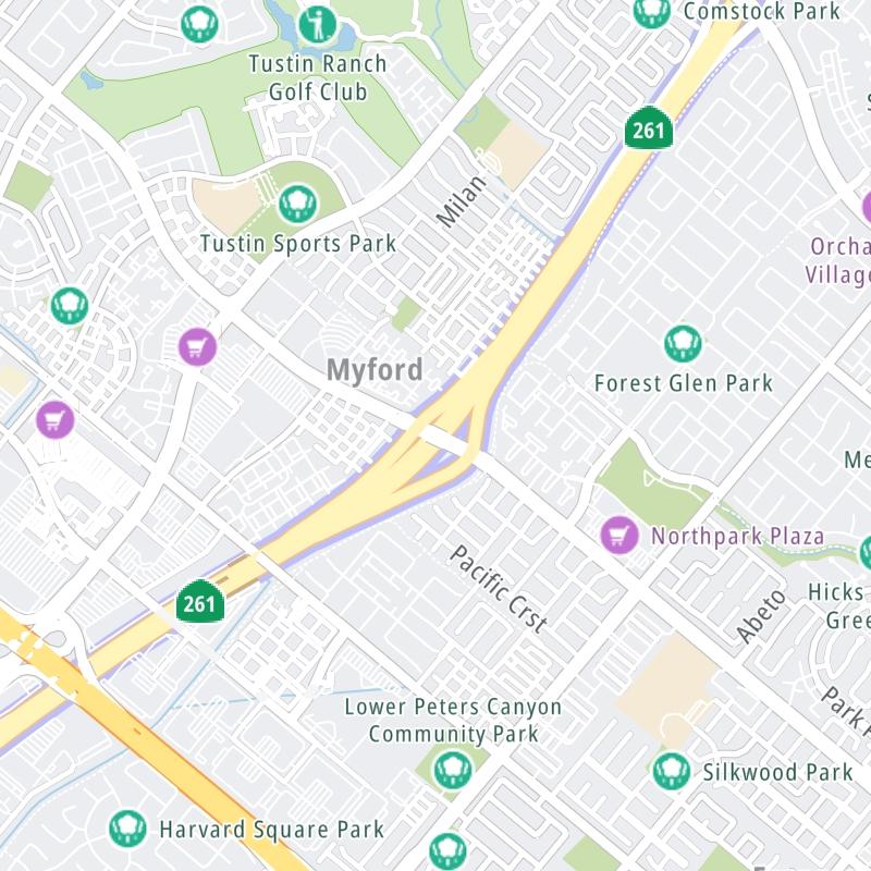
The static map seen here shows a segment of CA 261 at Irvine Boulevard. The entirety of CA 261 can be seen in the fully-interactive map above, which includes linked markers. You may resize and reposition the interactive map to orient the road in relation to other landmarks.
There is also a complete list of exits below.
Tolls For Cars, SUVs, Pickups, etc.
▹ Toll as of July 1, 2023.
This data is coming soon.
For drivers paying with a transponder, the following passes will work on CA 261
Learn about transponders and accounts in California.
View MapAll Tolls / Calculator ▸
Our new toll and trip calculator is being constructed. For most roads, you can still use the legacy calculator for current, accurate tolls.
Turnpikes.com has partnered with Tiqets.com to bring you these excusive deals on attractions!
Select an exit or other location to get a separate map, including locations of available gas, EV charging, fast-food and other dining options, plus current weather and driving conditions.
Barranca Pkwy — Irvine
▸ GPS 33.694091000 X -117.826734000
NOTES: as Jamboree Road
Warner Ave — Irvine
▸ GPS 33.698445000 X -117.819077000
NOTES: as Jamboree Road
Edinger Ave — Irvine
▸ GPS 33.704399000 X -117.806148000
NOTES: as Jamboree Road
Walnut Ave — Irvine
▸ GPS 33.711849000 X -117.800878000
NOTES: as Jamboree Road
I-5 via Jamboree Rd — Irvine
▸ GPS 33.714721000 X -117.798648000
NOTES: NB off / SB on only
Exit 2Irvine Boulevard — Irvine
▸ GPS 33.726430000 X -117.779006000
NOTES:
Irvine Ranch Mainline NB — Irvine
▸ GPS 33.730768000 X -117.775029000
NOTES: NB toll gantry
Irvine Ranch Mainline SB — Irvine
▸ GPS 33.736341000 X -117.770737000
NOTES: SB toll gantry
Exit 3Portola Parkway — Irvine
▸ GPS 33.740837000 X -117.766969000
NOTES:
Exit 6ASantiago Cyn Rd / CA 241 South — North Tustin
▸ GPS 33.779869000 X -117.754453000
NOTES:
CA 241 North — North Tustin
▸ GPS 33.783561000 X -117.746857000
NOTES: CA 261 N merges into CA 241 N
Journey to key destinations around and adjacent to California!
Communities in this metro area include Los Angeles, Long Beach, Irvine, San Juan Capistrano, and Santa Ana.
Individual toll maps for this region are listed below.
Communities in this metro area include San Francisco, San Jose, Sausalito, and Menlo Park.
Individual toll maps for this region are listed below.
Communities in this metro area include San Diego, Chula Vista, and Tijuana, Mexico.
Individual toll maps for this region are listed below.