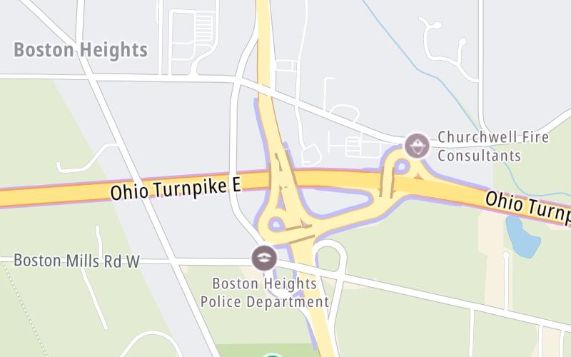
Map & services within two (2) miles
Interactive map shows available cameras, plus nearby fuel, food and lodging
See below for more about this area
Interactive map shows available cameras, plus nearby fuel, food and lodging
See below for more about this area
This is Exit 180 of the Ohio Turnpike.
This junction is located in Akron.
This location is in the Cleveland - Akron - Youngstown area.
This location's approximate GPS Coordinates are 41.25860 x -81.50120.
Which directions can I travel from here?
From this junction, traffic can enter traveling both westbound and eastbound. Traffic can also exit traveling both westbound and eastbound.
On to Streetsboro / SR 14 / I–480, about 6.9 miles away ►
◄ Back to Cleveland / SR 21 / I–77, about 7.1 miles away.
Which direction are tolls charged here?
The interactive map and lists on this page include key traveler services within two miles of this destination point.
You will find common services, including gas stations, truck stops, EV charging facilities, fast-food or family restaurants, and hotels. These are displayed on the interactive map as markers, which you can select for more information.
Current driving conditions and weather, along with a more complete list of key services, may be found below the map.

Cloudy
34°F / 1°C
Feels Like:
38°F / 3.1°C
Visibility
1 Mi / 2 Km
3-Hour Precip:
0 In / 0.0 Cm
North
Winds (N)
3.8 MPH / 6.1 KPH
Gusts:
6.5 MPH / 10.4 KPH
▸ Get the full forecast for This Location | The Cleveland - Akron - Youngstown area
Conditions and forecasts provided in partnership with AccuWeather.

Weather provided in partnership with AccuWeather.

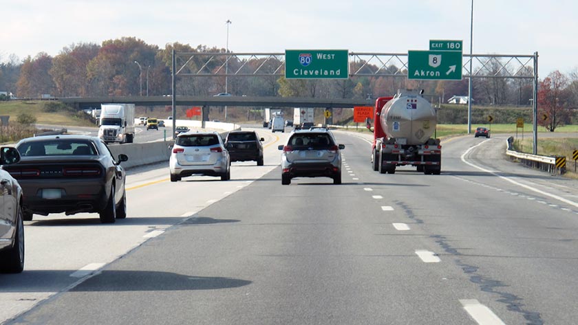
SR-8 AT I-80
Camera Direction: UNKNOWN. Source: ODOT - undetermined 44236
Cameras Closest To Akron / SR 8
886 Ft
1.75 Mi
2.93 Mi
3.26 Mi
About this photo:
Westbound traffic on the Ohio Turnpike flows past the exit ramp to OH 8, at Exit 180, just ahead of a curve in the road. Photo taken November 1, 2019.
Photo taken 11-01-2019
The map above shows all services within about a two (2) mile radius.

Destination Travel

Closest Fast Food
Fast food refers ONLY to quick-service and take-out diners. All restaurant types are shown on the map above.
No fast-food dining nearby.
Journey to key destinations around and adjacent to Ohio!
Communities in this metro area include Cleveland, Akron, Boardman, Lorain, Aurora, Youngstown, New Castle, Pennsylvania, and Beaver Falls, Pennsylvania.
Individual toll maps for this region are listed below.
Communities in this metro area include Toledo, Perrysburg, Maumee, Montpelier, and Wauseon.
Individual toll maps for this region are listed below.

Communities in this metro area include Castalia, Sandusky, Norwalk, Bellevue, Huron, Milan, and Monroeville.
Individual toll maps for this region are listed below.

Communities in this metro area include Gary, South Bend, Elkhart, Portage, and Fremont.
Individual toll maps for this region are listed below.
Communities in this metro area include Pittsburgh, Cranberry Township, Beaver Valley, New Castle, Washington, Uniontown, Cheat Lake, West Virginia, Boardman, Ohio, and Youngstown, Ohio.
Individual toll maps for this region are listed below.
Communities in this metro area include Parkersburg, North Hills, Vienna, and Belpre, Ohio.
Individual toll maps for this region are listed below.
Communities in this metro area include Detroit, Grosse Ile, Ann Arbor, Pontiac, and Lansing.
Individual toll maps for this region are listed below.

 Ohio Turnpike ▹
 Pennsylvania Turnpike ▹
 Beaver Valley Expressway ▹
 Indiana Toll Road ▹
 Chicago Skyway ▹
 Tri State Tollway ▹
 Cline Avenue Bridge ▹
 PA Turnpike 66 ▹
 Mon Fayette Expressway ▹
 PA Turnpike 576 ▹
 Memorial Bridge ▹
 Ambassador Bridge ▹
 Detroit Windsor Tunnel ▹


