Your selected location relative to roadway
See below for more about this area
See below for more about this area
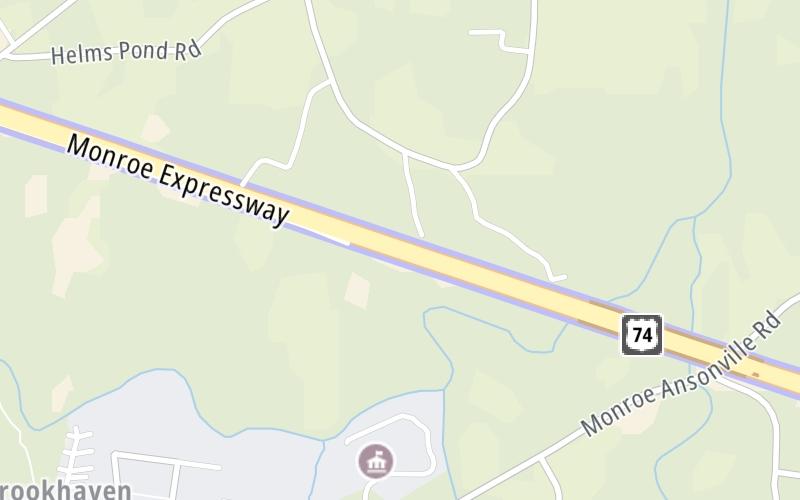
This toll point is located in Unionville. Monroe is nearby.
This location is in the Charlotte area.
This location's approximate GPS Coordinates are 35.00330 x -80.48808.
On to Austin Chaney Road, about 2.2 miles away ►
◄ Back to Morgan Mill Road, about 1.7 miles away.
Above: Map image © TomTom Intl BVThe interactive map will help you orient this location in relationship to other junctions.
Current driving conditions and weather may also be found below the map.

Mostly Cloudy
59°F / 14.9°C
Feels Like:
60°F / 15.4°C
Visibility
9 Mi / 14.5 Km
3-Hour Precip:
0 In / 0.0 Cm
West Northwest
Winds (WNW)
2.4 MPH / 3.9 KPH
Gusts:
6.3 MPH / 10.1 KPH
▸ Get the full forecast for the Charlotte area
Conditions and forecasts provided in partnership with AccuWeather.

Weather provided in partnership with AccuWeather.

US 74 @ MM 268.5
Camera Direction: EAST. Source: NCDOT - Charlotte 28174
Cameras Closest To M11/M12 Mainline Toll Gantry
0.32 Mi
0.64 Mi
2.23 Mi
2.29 Mi
2.77 Mi
There are no currently-available photos for this location.
Journey to key destinations around and adjacent to North Carolina!
Communities in this metro area include Charlotte, Wesley Chapel, Monroe, Unionville, and Fairview.
Individual toll maps for this region are listed below.

Communities in this metro area include Raleigh, Durham, Apex, Morrisville, Carpenter, and Chapel Hill.
Individual toll maps for this region are listed below.
Communities in this metro area include Norfolk, Chesapeake, Virginia Beach, Newport News, Portsmouth, Suffolk, and Moyock, North Carolina.
Individual toll maps for this region are listed below.
Communities in this metro area include Greenville, Spartanburg, Piedmont, Simpsonville, Anderson, and Asheville, North Carolina.
Individual toll maps for this region are listed below.

 Monroe Expressway ▹
 Triangle Expressway ▹
 Chesapeake Bay Bridge Tunnel ▹
 Chesapeake Expressway ▹
 Downtown Tunnel ▹
 South Norfolk Jordan Bridge ▹
 Midtown Tunnel ▹
 Dominion Boulevard Veterans Bridge ▹
 Southern Connector ▹


