Monroe Expressway At Rocky River Road

Advertising
Advertising

Map & services within two (2) miles

Interactive map shows available cameras, plus nearby fuel, food and lodging

See below for more about this area

Advertising
Advertising

About This Location

Rocky River Road

At A Glance

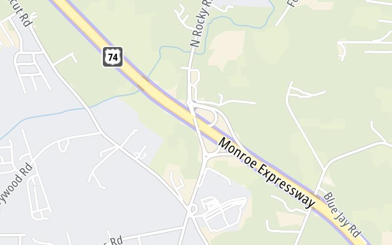
This is Exit 260 of the Monroe Expressway.

This junction is located in Unionville. Wesley Chapel and Monroe are nearby. NOTE: to Charlotte-Monroe Executive Airport.

This location is in the Charlotte area.

Interactive Map Above

This location's approximate GPS Coordinates are 35.06338 x -80.59304.

Which directions can I travel from here?

From this junction, traffic can enter traveling both westbound and eastbound. Traffic can also exit traveling both westbound and eastbound.

On to M07/M08 Mainline Toll Gantry, about 1.7 miles away ►

◄ Back to M05/M06 Mainline Toll Gantry, about 0.6 miles away.

Which direction are tolls charged here?

Tolls are not charged or collected at this junction.

View Map Travel Conditions

Above: Map image © TomTom Intl BV

Using The POI Map

The interactive map and lists on this page include key traveler services within two miles of this destination point.

You will find common services, including gas stations, truck stops, EV charging facilities, fast-food or family restaurants, and hotels. These are displayed on the interactive map as markers, which you can select for more information.

Current driving conditions and weather, along with a more complete list of key services, may be found below the map.

View Map Weather

Static map of Monroe Expressway at Rocky River Road
Static map. Interactive map is above.
Advertising
Advertising

Travel Conditions At Rocky River Road

Current Weather And Visibility

  • 19 7 03
  • Mostly Cloudy

    76°F / 24.5°C

    Feels Like:

    78°F / 25.6°C

  • Visibility

    10 Mi / 16.1 Km

    3-Hour Precip:

    0 In / 0.0 Cm

  • South Southwest
    Winds (SSW)

    5.1 MPH / 8.2 KPH

    Gusts:

    9.7 MPH / 15.6 KPH

▸ Get the full forecast for This Location | The Charlotte area

Available Cameras

No camera feed …

There is no currently-available traffic camera feed for this location.

Advertising
Advertising

Travel Pictures

No photos …

There are no currently-available photos for this location.

Advertising
Advertising

Closest Food, Gas, EV And Other Services Near Rocky River Road

The map above shows all services within about a two (2) mile radius.

Hotels and destinations header

Hotels & Airports

Destination Travel

Fuel, EV and convenience store header

Gas & EV Charging

Closest Gas Stations

Citgo

CITGO

4304 Rocky River Road North • 0.82 miles

Store/Fuel Brand: Citgo

View Map

Closest EV Chargers

PURE POWER CONTRACTORS

2812 Gray Fox Road • 1.57 miles

CONNECTOR: Chademo
POWER: 50 KW @ 400 V
CURRENT: 125 Amp DC

EV CONNECT

2812 Gray Fox Road • 1.59 miles

CONNECTOR: Chademo
POWER: 50 KW @ V
CURRENT: Amp DC

CHARGEPOINT

4712 West Highway 74 • 1.59 miles

CONNECTOR: IEC62196Type1CCS
POWER: 24 KW @ 920 V
CURRENT: 26 Amp DC

CHARGEPOINT

4708 West Highway 74 • 1.60 miles

CONNECTOR: IEC62196Type1
POWER: 12 KW @ 240 V
CURRENT: 50 Amp AC1

View Map

Coffee, snacks and dining header

Fast Food & Beverage

Closest Fast Food

Fast food refers ONLY to quick-service and take-out diners. All restaurant types are shown on the map above.

View Map

No fast-food dining nearby.

Discover North Carolina Attractions

Advertising
Advertising

EXPLORE NORTH CAROLINA

Journey to key destinations around and adjacent to North Carolina!

Map Of This Region ▹

Communities in this metro area include Charlotte, Wesley Chapel, Monroe, Unionville, and Fairview.

Individual toll maps for this region are listed below.

Map Of This Region ▹

Communities in this metro area include Raleigh, Durham, Apex, Morrisville, Carpenter, and Chapel Hill.

Individual toll maps for this region are listed below.

Map Of This Region ▹

Communities in this metro area include Norfolk, Chesapeake, Virginia Beach, Newport News, Portsmouth, Suffolk, and Moyock, North Carolina.

Individual toll maps for this region are listed below.

Map Of This Region ▹

Communities in this metro area include Greenville, Spartanburg, Piedmont, Simpsonville, Anderson, and Asheville, North Carolina.

Individual toll maps for this region are listed below.

Advertising
Advertising
Turnpikes.com is proud to partner with the following: