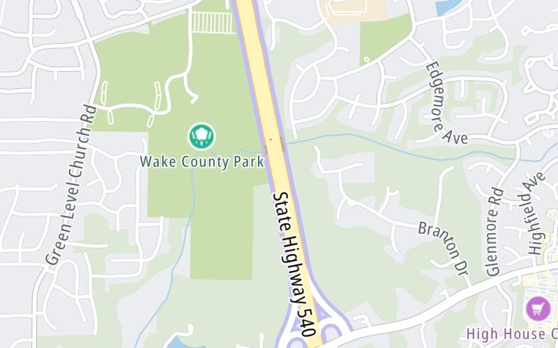
Triangle Expressway At T17/T18 Mainline Toll Gantry

T17/T18 Mainline Toll Gantry

At A Glance

This toll plaza is located in Cary.

This location is in the Raleigh - Durham area.

▾ Interactive Map Below ▾

This location's approximate GPS Coordinates are 35.79220 x -78.88859.

The next exit is Morrisville Parkway, approximately 1.2 miles away ►

◄ The previous exit is Green Level West Rd., approximately 0.7 miles away.

Which direction are tolls charged here?

  • ▸ Southbound
  • ▸ Northbound

▾ Travel Conditions ▾

Above: Map image © TomTom Intl BV

Using The POI Map

The interactive map will help you orient this location in relationship to other junctions.

Current driving conditions and weather may also be found below the map.

View Map ▾Weather ▾

Static map of Triangle Expressway at T17/T18 Mainline Toll Gantry
Static map. Interactive map is below.

Because of the nature of this location, no services are displayed. On most exit or junction pages, a summary of the closest services around the junction will be shown, along with detailed lists of services within two miles.

View Map ▾

Advertising
Advertising

Interactive Exit Map Of Triangle Expressway

Your Selected Location Relative To Roadway

Advertising
Advertising

Travel Conditions At T17/T18 Mainline Toll Gantry

Current Weather And Visibility

  • 20 7 09
  • Rain

    66°F / 19°C

    Feels Like:

    62°F / 16.5°C

  • Visibility

    8 Mi / 12.9 Km

    3-Hour Precip:

    1.11 In / 2.8 Cm

  • North Northeast
    Winds (NNE)

    5.1 MPH / 8.3 KPH

    Gusts:

    13 MPH / 20.9 KPH

▸ Get the full forecast for the Raleigh - Durham area

Available Cameras

NC 540 (TOLL) @ GREEN LEVEL WEST RD

NC 540 (TOLL) @ GREEN LEVEL WEST RD

Camera Direction: NORTH. Source: NCDOT - Durham 27519

Cameras Closest To T17/T18 Mainline Toll Gantry

Camera Direction: NORTH. Source: NCDOT - Durham 27519

0.65 Mi

Camera Direction: SOUTH. Source: NCDOT - Durham 27519

0.72 Mi

Camera Direction: SOUTH. Source: NCDOT - Durham 27519

1.20 Mi

Camera Direction: EAST. Source: NCDOT - Durham 27519

1.60 Mi

Camera Direction: EAST. Source: NCDOT - Durham 27519

2.13 Mi

Travel Pictures

No photos …

There are no currently-available photos for this location.

Advertising
Advertising

EXPLORE NORTH CAROLINA

Journey to key destinations around and adjacent to North Carolina!

Map Of This Region ▹

Communities in this metro area include Charlotte, Wesley Chapel, Monroe, Unionville, and Fairview.

Individual toll maps for this region are listed below.

Map Of This Region ▹

Communities in this metro area include Raleigh, Durham, Apex, Morrisville, Carpenter, and Chapel Hill.

Individual toll maps for this region are listed below.

Map Of This Region ▹

Communities in this metro area include Norfolk, Chesapeake, Virginia Beach, Newport News, Portsmouth, Suffolk, and Moyock, North Carolina.

Individual toll maps for this region are listed below.

Advertising
Advertising
Turnpikes.com is proud to partner with the following: