Oakland Traffic And Weather

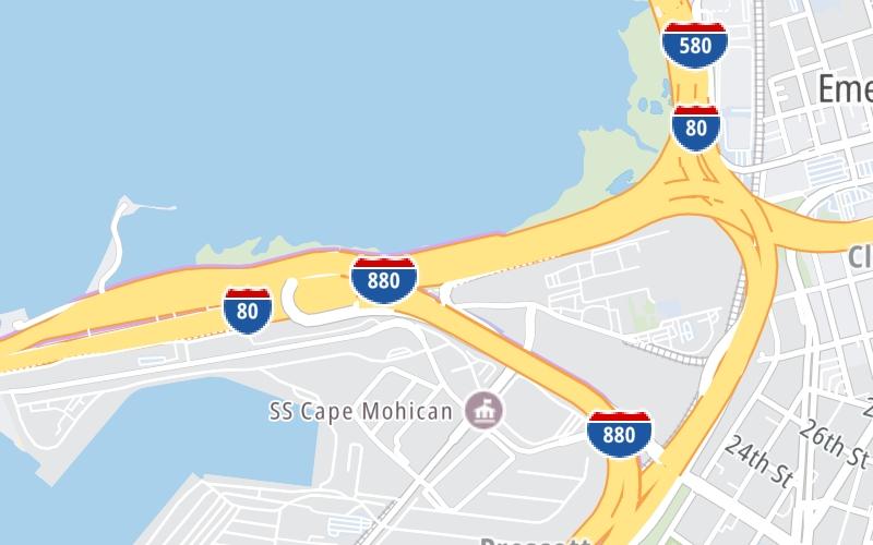
Static map of San Francisco Oakland Bay Bridge at I–80 / I–580 Interchange

Right Now At I–80 / I–580 Interchange and The San Francisco Oakland Bay Bridge

Current Weather And Visibility

7:43 pm Local Time

  • 19 7 11
  • Cloudy

    62°F / 16.5°C

    Feels Like:

    60°F / 15.3°C

  • Visibility

    8 Mi / 12.9 Km

    3-Hour Precip:

    0 In / 0.0 Cm

  • South Southeast
    Winds (SSE)

    7.1 MPH / 11.4 KPH

    Gusts:

    15.3 MPH / 24.6 KPH

Conditions and forecasts provided in partnership with AccuWeather.

AccuWeather logo

Weather provided in partnership with AccuWeather.

AccuWeather logo

Forecast weather and driving conditions follow the jump. These include an hour-by-hour forecast for the next 12-hours, a three-day forecast and an extended forecast, for extended travel planning.

An area traffic map, with available traffic cameras, shows driving conditions, from current traffic to mother nature's influence on the road. These follow the short-range forecasts below.

Driving Forecast ▾Traffic Map ▾

Advertising
Advertising

Driving Forecast For Oakland, At I–80 / I–580 Interchange

Next 12 Hours

7:43 pm Local Time

Conditions and forecasts provided in partnership with AccuWeather.

AccuWeather logo

Weather provided in partnership with AccuWeather.

AccuWeather logo

Available Cameras

I-80 @ GRAND AVE

I-80 @ GRAND AVE

Camera Direction: EAST. Source: Caltrans - Berkeley 94607

Cameras Closest To I–80 / I–580 Interchange

Camera Direction: EAST. Source: Caltrans - Berkeley 94607

89 Ft

Camera Direction: EAST. Source: Caltrans - Berkeley 94607

0.30 Mi

Camera Direction: WEST. Source: Caltrans - Berkeley 94607

0.51 Mi

Camera Direction: SOUTH. Source: Caltrans - Berkeley 94608

0.62 Mi

Camera Direction: EAST. Source: Caltrans - Berkeley 94607

0.74 Mi

There are many more cameras to view. Please see the map below to see all cameras within a two-mile (2 mile) radius.

Next Three (3) Days

Thursday November 21

Thursday forecast: Steady rain becoming intermittent; breezy this morning

Rain

100% Chance Rain

63° F/17.2° C

S Wind

14 to 31 Mi/

22 to 50 Km

Sunrise

6:57 AM

Thursday night: Steady rain becoming intermittent; breezy this morning

Cloudy

25% Chance Rain

59° F/15.0° C

S Wind

15 to 38 Mi/

24 to 61 Km

Sunset

4:54 PM

Friday November 22

Friday forecast: Windy with periods of rain, some heavy; expect slow travel during the morning commute

Rain

99% Chance Rain

65° F/18.3° C

S Wind

16 to 30 Mi/

26 to 48 Km

Sunrise

6:58 AM

Friday night: Windy with periods of rain, some heavy; expect slow travel during the morning commute

Showers

98% Chance Rain

53° F/11.7° C

SW Wind

9 to 17 Mi/

15 to 28 Km

Sunset

4:53 PM

Saturday November 23

Saturday forecast: A blend of sun and clouds

Intermittent Clouds

25% Chance Rain

61° F/16.1° C

WSW Wind

8 to 16 Mi/

13 to 26 Km

Sunrise

6:59 AM

Saturday night: A blend of sun and clouds

Cloudy

25% Chance Rain

46° F/7.8° C

S Wind

6 to 10 Mi/

9 to 17 Km

Sunset

4:53 PM

Advertising
Advertising

Interactive Traffic Map

I–80 / I–580 Interchange

At A Glance

This junction is located in Oakland, at GPS 37.82542 x -122.30369.

This location is in the San Francisco Bay Area area.

◄ The previous exit is West Grand Ave / I–880, approximately 0.3 miles away.

Above: Map image © TomTom Intl BV

Area Traffic Conditions

Pan and zoom the map as you desire. Select cameras to see on-road traffic feeds; pick exits and other markers for conditions at those locations.

Advertising
Advertising

Extended Forecast For Oakland, At I–80 / I–580 Interchange

Ten (10) Day Travel Planner

Go Online Before You Go On The Road!®

Conditions and forecasts provided in partnership with AccuWeather.

AccuWeather logo

Weather provided in partnership with AccuWeather.

AccuWeather logo
Advertising
Advertising

EXPLORE CALIFORNIA

Journey to key destinations around and adjacent to California!

Map Of This Region ▹

Communities in this metro area include Los Angeles, Long Beach, Irvine, San Juan Capistrano, and Santa Ana.

Individual toll maps for this region are listed below.

Map Of This Region ▹

Communities in this metro area include San Diego, Chula Vista, and Tijuana, Mexico.

Individual toll maps for this region are listed below.

Advertising
Advertising
Turnpikes.com is proud to partner with the following: