SH 45 N Map

Advertising
Advertising
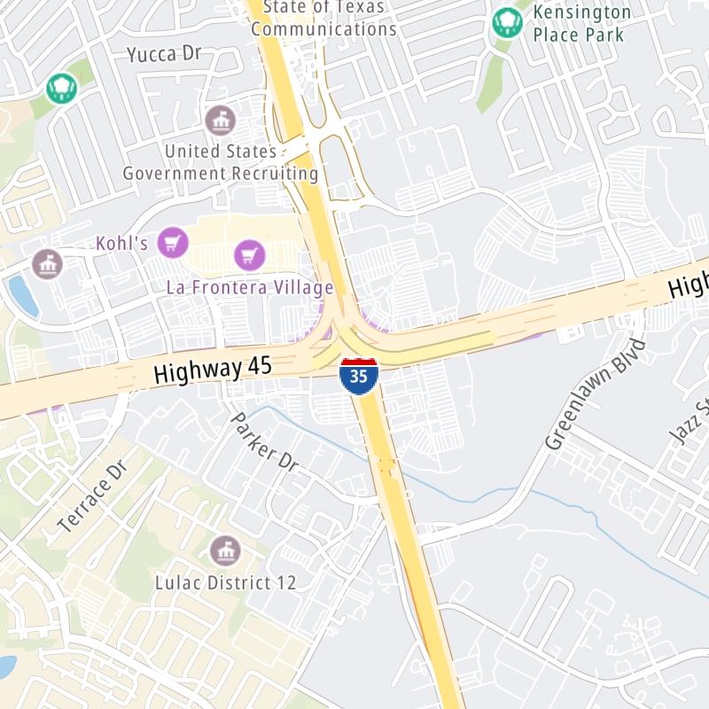
Static map a segment of SH 45 N

A Quick Look At SH 45 N

This local toll road serves several key cities, including Austin, Cedar Park, Round Rock, and Pflugerville.

The static map seen here shows a segment of SH 45 N at I-35 N. The entirety of SH 45 N can be seen in the fully-interactive map below, which includes linked markers. You may resize and reposition the interactive map to orient the road in relation to other landmarks.

There is also a complete list of exits below the interactive map.

View Map ▾Exit / POI List ▾

What Does It Cost To Use SH 45 N?

Tolls For Cars, SUVs, Pickups, etc.

This data will be here soon.

Transponders You Can Use

For drivers paying with a transponder, the following passes will work on SH 45 N

  • txtag
  • eztag
  • tolltag
  • pikepass
  • k-tag

Learn about transponders and accounts in Texas.

View Map ▾All Tolls / Calculator ▸

Our new toll and trip calculator is being constructed. For most roads, you can still use the legacy calculator for current, accurate tolls.

Advertising
Advertising

Using The Interactive Toll Map

You may pan and zoom the interactive map. There are markers you may select for a separate map of that point of interest or location, which will show any nearby dining, gas, EV charging, hotels and other services.

A complete list of exits and other points-of-interest may be found below the map. Exits and gantries will display the toll agency responsible for tolls on that portion of the roadway.

View Map ▾Exit / POI List ▾

Advertising
Advertising

SH 45 N Toll Map

This map of SH 45 N displays markers for exits and tolling points, which you can select to get a close-up map of that point of interest or location.

The points-of-interest shown on this map are also listed below, ordered from west to east.

Discover Texas Attractions

Advertising
Advertising

List Of Exits / Points Of Interest For SH 45 N

Select an exit or other location to get a separate map, including locations of available gas, EV charging, fast-food and other dining options, plus current weather and driving conditions.

Pecan Park Blvd

Pecan Park Blvd — Cedar Park

View Map & Info

▸ GPS 30.466323000 X -97.804154000
NOTES: West terminus of SH 45 N / Roadway merges with FM 620

TxDoT Texas Department Of Transportation manages this segment.

183A Toll Road / U.S. Hwy 183

183A Toll Road / U.S. Hwy 183 — Cedar Park

View Map & Info

▸ GPS 30.468681000 X -97.796600000
NOTES: North for 183A Toll Road

TxDoT Texas Department Of Transportation manages this segment.

SH 45 N West Plaza

SH 45 N West Plaza — Jollyville

View Map & Info

▸ GPS 30.474559000 X -97.774978000
NOTES: Mainline and ramp gantry cluster

TxDoT Texas Department Of Transportation manages this segment.

Parmer Ln

Parmer Ln — Jollyville

View Map & Info

▸ GPS 30.476416000 X -97.764814000
NOTES: Also CR 734

TxDoT Texas Department Of Transportation manages this segment.

FM 620 / Pearson Ranch Rd

FM 620 / Pearson Ranch Rd — Brushy Creek

View Map & Info

▸ GPS 30.481278000 X -97.745014000
NOTES:

TxDoT Texas Department Of Transportation manages this segment.

O'Connor Dr

O'Connor Dr — Brushy Creek

View Map & Info

▸ GPS 30.479652000 X -97.718909000
NOTES: EB exit here for Loop 1

TxDoT Texas Department Of Transportation manages this segment.

Loop 1/MoPac

Loop 1/MoPac — Brushy Creek

View Map & Info

▸ GPS 30.476453000 X -97.702544000
NOTES:

TxDoT Texas Department Of Transportation manages this segment.

CR 172 / La Frontera Blvd

CR 172 / La Frontera Blvd — Round Rock

View Map & Info

▸ GPS 30.477857000 X -97.693966000
NOTES: EB exit here for I-35 S / FM 1325

TxDoT Texas Department Of Transportation manages this segment.

I-35 N

I-35 N — Round Rock

View Map & Info

▸ GPS 30.480294000 X -97.673969000
NOTES: EB 45 to I-35 N / WB 45 to I-35 N

TxDoT Texas Department Of Transportation manages this segment.

Greenlawn Blvd

Greenlawn Blvd — Round Rock

View Map & Info

▸ GPS 30.482801000 X -97.660403000
NOTES:

TxDoT Texas Department Of Transportation manages this segment.

A W Grimes Blvd

A W Grimes Blvd — Round Rock

View Map & Info

▸ GPS 30.485498000 X -97.650101000
NOTES: WB exit here for I-35 S or Greenlawn Blvd

TxDoT Texas Department Of Transportation manages this segment.

Donnell Dr / Kenney Ft Blvd

Donnell Dr / Kenney Ft Blvd — Round Rock

View Map & Info

▸ GPS 30.488200000 X -97.629008000
NOTES: This exit not completed

TxDoT Texas Department Of Transportation manages this segment.

N Heatherwilde Blvd

N Heatherwilde Blvd — Pflugerville

View Map & Info

▸ GPS 30.483765000 X -97.613613000
NOTES:

TxDoT Texas Department Of Transportation manages this segment.

SH 45 N East Plaza

SH 45 N East Plaza — Pflugerville

View Map & Info

▸ GPS 30.482608000 X -97.610980000
NOTES: Mainline and ramp gantry cluster

TxDoT Texas Department Of Transportation manages this segment.

SH 130

SH 130 — Pflugerville

View Map & Info

▸ GPS 30.474582000 X -97.594450000
NOTES: Toll road

TxDoT Texas Department Of Transportation manages this segment.

FM 685 / Kelly Ln

FM 685 / Kelly Ln — Pflugerville

View Map & Info

▸ GPS 30.472182000 X -97.591649000
NOTES: East terminus of toll road / road mergest with Kelly Ln

TxDoT Texas Department Of Transportation manages this segment.

Advertising
Advertising

EXPLORE TEXAS

Journey to key destinations around and adjacent to Texas!

Map Of This Region ▹

Communities in this metro area include Dallas, Fort Worth, Plano, Addison, Frisco, Grand Prairie, Arlington, Carrrollton, and Lake Dallas.

Individual toll maps for this region are listed below.

Map Of This Region ▹

Communities in this metro area include Houston, Humble, Tomball, Sugar Land, Galveston, Pearland, and Katy.

Individual toll maps for this region are listed below.

Map Of This Region ▹

Communities in this metro area include Austin, Pflugerville, Round Rock, Georgetown, Cedar Park, Mustang Ridge, Manor, Serenada, Sunset Valley, and Hutto.

Individual toll maps for this region are listed below.

Map Of This Region ▹

Communities in this metro area include Tyler, Wood Springs, Noonday, and Whitehouse.

Individual toll maps for this region are listed below.

Map Of This Region ▹

Communities in this metro area include Brownsville, Heroica Matamoros, Tamaulipas, San Benito, Harlingen, and Rancho Viejo.

Individual toll maps for this region are listed below.

Map Of This Region ▹

Communities in this metro area include Lawton, Fort Sill, Geronimo, and Cache.

Individual toll maps for this region are listed below.

Advertising
Advertising
Turnpikes.com is proud to partner with the following: