Your selected location relative to roadway
See below for more about this area
See below for more about this area
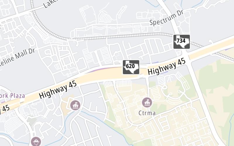
This toll point is located in Jollyville. Brushy Creek and Austin are nearby. NOTE: Mainline and ramp gantry cluster.
This location is in the Austin - Round Rock area.
This location's approximate GPS Coordinates are 30.47456 x -97.77498.
On to Parmer Ln, about 0.7 miles away ►
◄ Back to 183A Toll Road / U.S. Hwy 183, about 1.3 miles away.
Above: Map image © TomTom Intl BVThe interactive map will help you orient this location in relationship to other junctions.
Current driving conditions and weather may also be found below the map.

Partly Cloudy
69°F / 20.6°C
Feels Like:
66°F / 18.8°C
Visibility
10 Mi / 16.1 Km
3-Hour Precip:
0 In / 0.0 Cm
North Northeast
Winds (NNE)
10.4 MPH / 16.7 KPH
Gusts:
10.4 MPH / 16.7 KPH
▸ Get the full forecast for the Austin - Round Rock area
Conditions and forecasts provided in partnership with AccuWeather.

Weather provided in partnership with AccuWeather.

US-183 NB @ RM-620
Camera Direction: NORTH. Source: TXDOT - Austin 78750
Cameras Closest To SH 45 N West Plaza
1.36 Mi
1.40 Mi
1.41 Mi
1.42 Mi
1.45 Mi
There are no currently-available photos for this location.
Journey to key destinations around and adjacent to Texas!
Communities in this metro area include Dallas, Fort Worth, Plano, Addison, Frisco, Grand Prairie, Arlington, Carrrollton, and Lake Dallas.
Individual toll maps for this region are listed below.
Communities in this metro area include Houston, Humble, Tomball, Sugar Land, Galveston, Pearland, and Katy.
Individual toll maps for this region are listed below.
Communities in this metro area include Austin, Pflugerville, Round Rock, Georgetown, Cedar Park, Mustang Ridge, Manor, Serenada, Sunset Valley, and Hutto.
Individual toll maps for this region are listed below.
Communities in this metro area include Tyler, Wood Springs, Noonday, and Whitehouse.
Individual toll maps for this region are listed below.

Communities in this metro area include Brownsville, Heroica Matamoros, Tamaulipas, San Benito, Harlingen, and Rancho Viejo.
Individual toll maps for this region are listed below.

Communities in this metro area include Lawton, Fort Sill, Geronimo, and Cache.
Individual toll maps for this region are listed below.


 Addison Airport Toll Tunnel ▹
 Chisholm Trail Parkway ▹
 Dallas North Tollway ▹
 Lewisville Lake Toll Bridge ▹
 Mountain Creek Lake Toll Bridge ▹
 President George Bush Turnpike ▹
 Sam Rayburn Tollway ▹
 360 Tollway ▹
 Grand Parkway ▹
 Hardy Toll Road ▹
 Sam Houston Tollway ▹
 Tomball Tollway ▹
 Westpark Tollway ▹
 Loop 1 ▹
 SH 130 ▹
 SH 45 N ▹
 SH 45 SW ▹
 183A Toll Road ▹
 183 Toll Road ▹
 290 Toll Road ▹
 71 Toll Road ▹
 Toll 49 ▹
 SH 550 ▹
 H E Bailey Turnpike ▹


