Map & services within two (2) miles
Interactive map shows available cameras, plus nearby fuel, food and lodging


See below for more about this area
Interactive map shows available cameras, plus nearby fuel, food and lodging
See below for more about this area
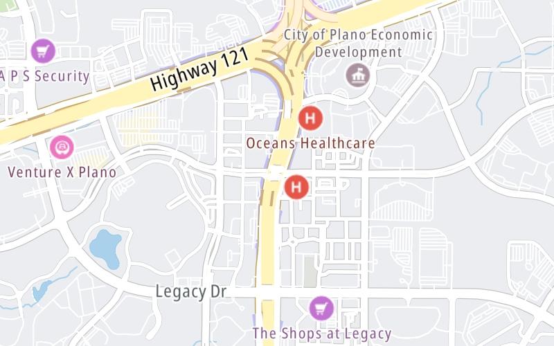
This junction is located in Plano. NOTE: NB On/NB Off.
This location is in the Dallas - Fort Worth area.
This location's approximate GPS Coordinates are 33.08416 x -96.82396.
Which directions can I travel from here?
From this junction, traffic can only enter going northbound. Traffic can only exit going northbound.
On to Sam Rayburn Tollway, about 0.5 miles away ►
◄ Back to Legacy Drive, about 0.4 miles away.
Which direction are tolls charged here?
The interactive map and lists on this page include key traveler services within two miles of this destination point.
You will find common services, including gas stations, truck stops, EV charging facilities, fast-food or family restaurants, and hotels. These are displayed on the interactive map as markers, which you can select for more information.
Current driving conditions and weather, along with a more complete list of key services, may be found below the map.

Sunny
86°F / 30.1°C
Feels Like:
97°F / 36.1°C
Visibility
12 Mi / 19.3 Km
3-Hour Precip:
0 In / 0.0 Cm
South Southeast
Winds (SSE)
3.5 MPH / 5.6 KPH
Gusts:
6.1 MPH / 9.8 KPH
▸ Get the full forecast for This Location | The Dallas - Fort Worth area
Conditions and forecasts provided in partnership with AccuWeather.

Weather provided in partnership with AccuWeather.
There is no currently-available traffic camera feed for this location.
There are no currently-available photos for this location.
The map above shows all services within about a two (2) mile radius.

Destination Travel

Closest Gas Stations
RACETRAC
5700 State Highway 121 • 0.77 miles
Store/Fuel Brand: Racetrac
ATLANTIC GROUP
5800 Tennyson Parkway • 0.92 miles
Store/Fuel Brand:
MITCHELL OIL CO
1125 Legacy Drive • 0.95 miles
Store/Fuel Brand:
ENCANA OIL & GAS
5851 Legacy Circle • 1,243 feet
Store/Fuel Brand:
Closest EV Chargers
CAMBRIA HOTEL - PLANO FRISCO
7500 Parkwood Boulevard • 0.42 miles
CONNECTOR: Tesla
POWER: 7 KW @ 240 V
CURRENT: 30 Amp AC1
CAMBRIA HOTEL - PLANO FRISCO
7500 Parkwood Boulevard • 0.42 miles
CONNECTOR: IEC62196Type1
POWER: 7 KW @ 240 V
CURRENT: 30 Amp AC1
PLANO, TX SUPERCHARGER
7161 Bishop Road • 0.45 miles
CONNECTOR: Tesla
POWER: 72 KW @ 400 V
CURRENT: 180 Amp DC
GRANITE PARK THREE
5601 Granite Parkway • 0.45 miles
CONNECTOR: IEC62196Type1
POWER: 6 KW @ 208 V
CURRENT: 30 Amp AC1

Closest Fast Food
Fast food refers ONLY to quick-service and take-out diners. All restaurant types are shown on the map above.
THE BISCUIT BAR
5880 State Highway 121 • 0.43 miles
ZOE'S KITCHEN
5717 Legacy Drive • 0.45 miles
CHIPOTLE
5717 Legacy Drive • 0.45 miles
POTBELLY
5717 Legacy Drive • 0.46 miles
CHIP'S OLD FASHIONED HAMBURGERS
5872 State Highway 121 • 0.47 miles
VILLAGE BURGER BAR
5700 Legacy Drive • 0.53 miles
TACODELI
8442 Parkwood Boulevard • 0.77 miles
LA MADELEINE
8008 State Highway 121 • 0.83 miles
Journey to key destinations around and adjacent to Texas!
Communities in this metro area include Dallas, Fort Worth, Plano, Addison, Frisco, Grand Prairie, Arlington, Carrrollton, and Lake Dallas.
Individual toll maps for this region are listed below.
Communities in this metro area include Houston, Humble, Tomball, Sugar Land, Galveston, Pearland, and Katy.
Individual toll maps for this region are listed below.
Communities in this metro area include Austin, Pflugerville, Round Rock, Georgetown, Cedar Park, Mustang Ridge, Manor, Serenada, Sunset Valley, and Hutto.
Individual toll maps for this region are listed below.
Communities in this metro area include Tyler, Wood Springs, Noonday, and Whitehouse.
Individual toll maps for this region are listed below.

Communities in this metro area include Brownsville, Heroica Matamoros, Tamaulipas, San Benito, Harlingen, and Rancho Viejo.
Individual toll maps for this region are listed below.

Communities in this metro area include Lawton, Fort Sill, Geronimo, and Cache.
Individual toll maps for this region are listed below.


 Addison Airport Toll Tunnel ▹
 Chisholm Trail Parkway ▹
 Dallas North Tollway ▹
 Lewisville Lake Toll Bridge ▹
 Mountain Creek Lake Toll Bridge ▹
 President George Bush Turnpike ▹
 Sam Rayburn Tollway ▹
 360 Tollway ▹
 Grand Parkway ▹
 Hardy Toll Road ▹
 Sam Houston Tollway ▹
 Tomball Tollway ▹
 Westpark Tollway ▹
 Loop 1 ▹
 SH 130 ▹
 SH 45 N ▹
 SH 45 SW ▹
 183A Toll Road ▹
 183 Toll Road ▹
 290 Toll Road ▹
 71 Toll Road ▹
 Toll 49 ▹
 SH 550 ▹
 H E Bailey Turnpike ▹


