Map & services within two (2) miles
Interactive map shows available cameras, plus nearby fuel, food and lodging


See below for more about this area
Interactive map shows available cameras, plus nearby fuel, food and lodging
See below for more about this area
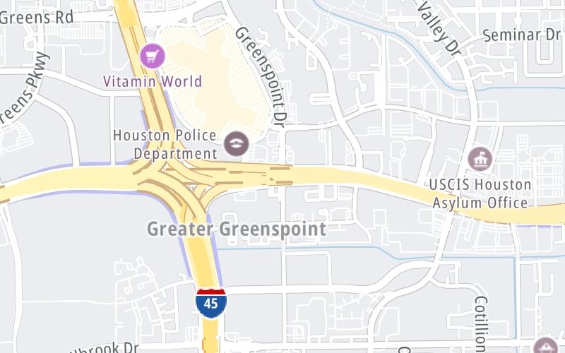
This junction is located in Houston.
This location is in the Houston - Galveston area.
This location's approximate GPS Coordinates are 29.94063 x -95.40750.
Which directions can I travel from here?
NOTE: This road is circular; therefore, the directions shown correspond as follows:
southbound = counter-clockwise / northbound = clockwise
From this junction, traffic can enter traveling both southbound and northbound. Traffic can also exit traveling both southbound and northbound.
On to Imperial Valley Drive, about 0.6 miles away ►
◄ Back to I–45 / North Freeway, about 0.4 miles away.
Which direction are tolls charged here?
Tolls are not charged or collected at this junction.
Above: Map image © TomTom Intl BVThe interactive map and lists on this page include key traveler services within two miles of this destination point.
You will find common services, including gas stations, truck stops, EV charging facilities, fast-food or family restaurants, and hotels. These are displayed on the interactive map as markers, which you can select for more information.
Current driving conditions and weather, along with a more complete list of key services, may be found below the map.

Mostly Cloudy
70°F / 20.9°C
Feels Like:
69°F / 20.5°C
Visibility
7 Mi / 11.3 Km
3-Hour Precip:
0 In / 0.0 Cm
North Northeast
Winds (NNE)
2.8 MPH / 4.4 KPH
Gusts:
8.4 MPH / 13.6 KPH
▸ Get the full forecast for This Location | The Houston - Galveston area
Conditions and forecasts provided in partnership with AccuWeather.

Weather provided in partnership with AccuWeather.
There is no currently-available traffic camera feed for this location.
There are no currently-available photos for this location.
The map above shows all services within about a two (2) mile radius.

Destination Travel

Closest Gas Stations
HOUSTON GULF ENERGY CORPORATION
16945 Northchase Drive • 0.39 miles
Store/Fuel Brand: Gulf
MOTIVA ENTERPRISES
16800 Greenspoint Park Drive • 0.45 miles
Store/Fuel Brand:
TEXACO
322 Benmar Drive • 0.56 miles
Store/Fuel Brand: Texaco
CHEVRON
105 Aldine Bender Road • 0.57 miles
Store/Fuel Brand: Chevron
Closest EV Chargers
HOLIDAY INN EXP
35 Aldine Bender Road • 0.59 miles
CONNECTOR: IEC62196Type1
POWER: 6 KW @ 208 V
CURRENT: 30 Amp AC1
MAC HAIK CHRYSLER DODGE JEEP RAM
11000 North Freeway • 1.06 miles
CONNECTOR: IEC62196Type1
POWER: 19 KW @ 238 V
CURRENT: 80 Amp AC1

Closest Fast Food
Fast food refers ONLY to quick-service and take-out diners. All restaurant types are shown on the map above.
WENDY'S
142 Greenspoint Mall • 0.54 miles
MCDONALD'S
392 North Sam Houston Parkway East • 0.58 miles
CHURCH'S CHICKEN
392 North Sam Houston Parkway East • 0.58 miles
POPEYES
16425 Imperial Valley Drive • 0.60 miles
BURGER KING
105 Aldine Bender Road • 0.62 miles
LITTLE CAESARS
16282 Imperial Valley Drive • 0.65 miles
DOMINO'S
50 Aldine Bender Road • 0.65 miles
SUPER CHICKEN
414 North Sam Houston Parkway East • 0.72 miles
Journey to key destinations around and adjacent to Texas!
Communities in this metro area include Dallas, Fort Worth, Plano, Addison, Frisco, Grand Prairie, Arlington, Carrrollton, and Lake Dallas.
Individual toll maps for this region are listed below.
Communities in this metro area include Houston, Humble, Tomball, Sugar Land, Galveston, Pearland, and Katy.
Individual toll maps for this region are listed below.
Communities in this metro area include Austin, Pflugerville, Round Rock, Georgetown, Cedar Park, Mustang Ridge, Manor, Serenada, Sunset Valley, and Hutto.
Individual toll maps for this region are listed below.
Communities in this metro area include Tyler, Wood Springs, Noonday, and Whitehouse.
Individual toll maps for this region are listed below.

Communities in this metro area include Brownsville, Heroica Matamoros, Tamaulipas, San Benito, Harlingen, and Rancho Viejo.
Individual toll maps for this region are listed below.

Communities in this metro area include Lawton, Fort Sill, Geronimo, and Cache.
Individual toll maps for this region are listed below.


 Addison Airport Toll Tunnel ▹
 Chisholm Trail Parkway ▹
 Dallas North Tollway ▹
 Lewisville Lake Toll Bridge ▹
 Mountain Creek Lake Toll Bridge ▹
 President George Bush Turnpike ▹
 Sam Rayburn Tollway ▹
 360 Tollway ▹
 Grand Parkway ▹
 Hardy Toll Road ▹
 Sam Houston Tollway ▹
 Tomball Tollway ▹
 Westpark Tollway ▹
 Loop 1 ▹
 SH 130 ▹
 SH 45 N ▹
 SH 45 SW ▹
 183A Toll Road ▹
 183 Toll Road ▹
 290 Toll Road ▹
 71 Toll Road ▹
 Toll 49 ▹
 SH 550 ▹
 H E Bailey Turnpike ▹


