Map & services within two (2) miles
Interactive map shows available cameras, plus nearby fuel, food and lodging


See below for more about this area
Interactive map shows available cameras, plus nearby fuel, food and lodging
See below for more about this area
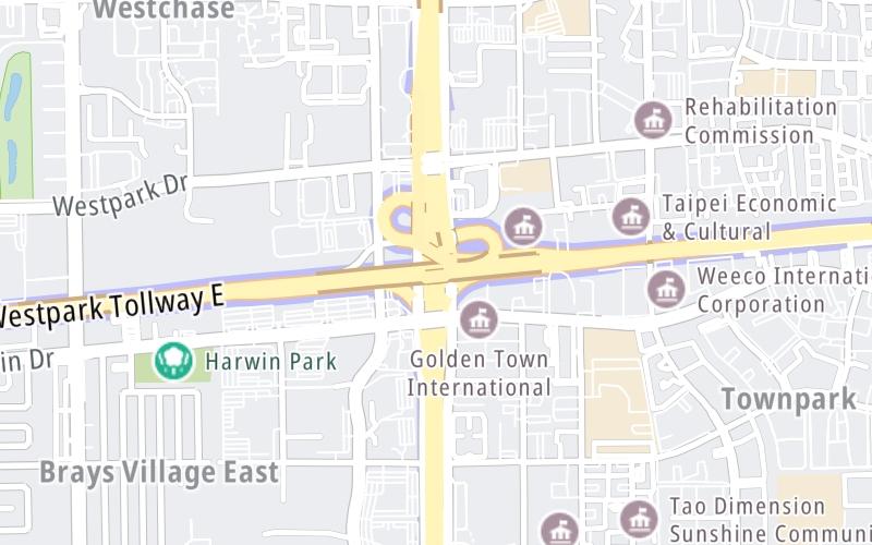
This junction is located in Houston.
This location is in the Houston - Galveston area.
This location's approximate GPS Coordinates are 29.71828 x -95.55727.
Which directions can I travel from here?
NOTE: This road is circular; therefore, the directions shown correspond as follows:
southbound = counter-clockwise / northbound = clockwise
From this junction, traffic can enter traveling both southbound and northbound. Traffic can also exit traveling both southbound and northbound.
On to Westpark Drive, about 0.2 miles away ►
◄ Back to Bellaire Boulevard, about 1.0 mile away.
▹ The Sam Houston Tollway and the Westpark Tollway connect here.
Which direction are tolls charged here?
The interactive map and lists on this page include key traveler services within two miles of this destination point.
You will find common services, including gas stations, truck stops, EV charging facilities, fast-food or family restaurants, and hotels. These are displayed on the interactive map as markers, which you can select for more information.
Current driving conditions and weather, along with a more complete list of key services, may be found below the map.

Mostly Cloudy
72°F / 22.4°C
Feels Like:
74°F / 23.1°C
Visibility
5 Mi / 8 Km
3-Hour Precip:
0 In / 0.0 Cm
North Northeast
Winds (NNE)
1.8 MPH / 3 KPH
Gusts:
5.5 MPH / 8.9 KPH
▸ Get the full forecast for This Location | The Houston - Galveston area
Conditions and forecasts provided in partnership with AccuWeather.

Weather provided in partnership with AccuWeather.
There is no currently-available traffic camera feed for this location.
There are no currently-available photos for this location.
The map above shows all services within about a two (2) mile radius.

Destination Travel

Closest Gas Stations
STOP N JOY
10304 Harwin Drive • 0.62 miles
Store/Fuel Brand:
AMIGOS FOOD MART
10301 Harwin Drive • 0.66 miles
Store/Fuel Brand:
REVOLUTIONS CHEVRON
10414 Richmond Avenue • 0.69 miles
Store/Fuel Brand: Chevron
LANDMARK INDUSTRIES
11111 Wilcrest Green Drive • 0.72 miles
Store/Fuel Brand:
Closest EV Chargers
FRESHBYTE SOFTWARE
10370 Richmond Avenue • 0.69 miles
CONNECTOR: IEC62196Type1
POWER: 7 KW @ 240 V
CURRENT: 30 Amp AC1
STAYBRIDGE UNITED - HOUSTON,TX - TESLA DESTINATION
9901 United Drive • 0.76 miles
CONNECTOR: Tesla
POWER: 7 KW @ 240 V
CURRENT: 30 Amp AC1
STAYBRIDGE UNITED - HOUSTON,TX - TESLA DESTINATION
9901 United Drive • 0.76 miles
CONNECTOR: IEC62196Type1
POWER: 7 KW @ 240 V
CURRENT: 30 Amp AC1
530512 BRIARPARK GREEN
3151 Briarpark Drive • 1.08 miles
CONNECTOR: IEC62196Type1
POWER: 6 KW @ 208 V
CURRENT: 30 Amp AC1

Closest Fast Food
Fast food refers ONLY to quick-service and take-out diners. All restaurant types are shown on the map above.
TEXAS HAMBURGER PALACE
5757 Ranchester Drive • 0.54 miles
BURGER KING
10414 Richmond Avenue • 0.69 miles
JACK IN THE BOX
10454 Richmond Avenue • 0.70 miles
FRENCHYS
10414 Richmond Avenue • 0.70 miles
CHUNGCHUN KOREAN RICE HOTDOGS
9798 Bellaire Boulevard • 0.93 miles
MCDONALD'S
6707 West Sam Houston Parkway South • 0.99 miles
TKK FRIED CHICKEN
9889 Bellaire Boulevard • 1.00 miles
CHICK-FIL-A
6840 West Sam Houston Parkway South • 1.05 miles
Journey to key destinations around and adjacent to Texas!
Communities in this metro area include Dallas, Fort Worth, Plano, Addison, Frisco, Grand Prairie, Arlington, Carrrollton, and Lake Dallas.
Individual toll maps for this region are listed below.
Communities in this metro area include Houston, Humble, Tomball, Sugar Land, Galveston, Pearland, and Katy.
Individual toll maps for this region are listed below.
Communities in this metro area include Austin, Pflugerville, Round Rock, Georgetown, Cedar Park, Mustang Ridge, Manor, Serenada, Sunset Valley, and Hutto.
Individual toll maps for this region are listed below.
Communities in this metro area include Tyler, Wood Springs, Noonday, and Whitehouse.
Individual toll maps for this region are listed below.

Communities in this metro area include Brownsville, Heroica Matamoros, Tamaulipas, San Benito, Harlingen, and Rancho Viejo.
Individual toll maps for this region are listed below.

Communities in this metro area include Lawton, Fort Sill, Geronimo, and Cache.
Individual toll maps for this region are listed below.


 Addison Airport Toll Tunnel ▹
 Chisholm Trail Parkway ▹
 Dallas North Tollway ▹
 Lewisville Lake Toll Bridge ▹
 Mountain Creek Lake Toll Bridge ▹
 President George Bush Turnpike ▹
 Sam Rayburn Tollway ▹
 360 Tollway ▹
 Grand Parkway ▹
 Hardy Toll Road ▹
 Sam Houston Tollway ▹
 Tomball Tollway ▹
 Westpark Tollway ▹
 Loop 1 ▹
 SH 130 ▹
 SH 45 N ▹
 SH 45 SW ▹
 183A Toll Road ▹
 183 Toll Road ▹
 290 Toll Road ▹
 71 Toll Road ▹
 Toll 49 ▹
 SH 550 ▹
 H E Bailey Turnpike ▹


