Map & services within two (2) miles
Interactive map shows available cameras, plus nearby fuel, food and lodging


See below for more about this area
Interactive map shows available cameras, plus nearby fuel, food and lodging
See below for more about this area
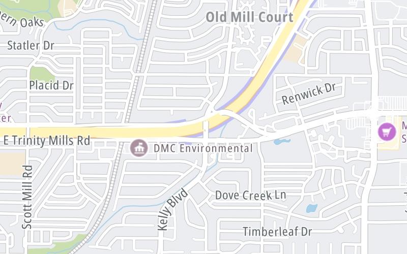
This junction is located in Addison. NOTE: WB On/EB Off.
This location is in the Dallas - Fort Worth area.
This location's approximate GPS Coordinates are 32.98603 x -96.86917.
Which directions can I travel from here?
From this junction, traffic can only enter going westbound. Traffic can only exit going eastbound.
On to Frankford Road, about 1.0 mile away ►
◄ Back to Josey Lane, about 1.3 miles away.
Which direction are tolls charged here?
The interactive map and lists on this page include key traveler services within two miles of this destination point.
You will find common services, including gas stations, truck stops, EV charging facilities, fast-food or family restaurants, and hotels. These are displayed on the interactive map as markers, which you can select for more information.
Current driving conditions and weather, along with a more complete list of key services, may be found below the map.

Mostly Cloudy
76°F / 24.4°C
Feels Like:
78°F / 25.3°C
Visibility
8 Mi / 12.9 Km
3-Hour Precip:
0 In / 0.0 Cm
South Southeast
Winds (SSE)
8.4 MPH / 13.6 KPH
Gusts:
19.7 MPH / 31.6 KPH
▸ Get the full forecast for This Location | The Dallas - Fort Worth area
Conditions and forecasts provided in partnership with AccuWeather.

Weather provided in partnership with AccuWeather.
There is no currently-available traffic camera feed for this location.
There are no currently-available photos for this location.
The map above shows all services within about a two (2) mile radius.

Destination Travel

Closest Gas Stations
VALERO
2718 Frankford Road • 0.76 miles
Store/Fuel Brand: Valero
FAST TRIP MART
2718 Frankford Road • 0.76 miles
Store/Fuel Brand:
QUIKTRIP
2929 Frankford Road • 0.87 miles
Store/Fuel Brand: QuikTrip
MURPHY USA
18041 Marsh Lane • 1.01 miles
Store/Fuel Brand: Murphy USA
Closest EV Chargers
SAVI HQ - CARROLLTON, TX
2520 Marsh Lane • 0.88 miles
CONNECTOR: IEC62196Type1
POWER: 7 KW @ 240 V
CURRENT: 30 Amp AC1
CHARGEPOINT
18211 Kelly Boulevard • 0.99 miles
CONNECTOR: IEC62196Type1
POWER: 6 KW @ 240 V
CURRENT: 27 Amp AC1
GENERAL ELECTRIC - DALLAS OFFICE
2508 Highlander Way • 1.39 miles
CONNECTOR: IEC62196Type1
POWER: 7 KW @ 240 V
CURRENT: 30 Amp AC1
CHARGEPOINT
3939 Briargrove Lane • 1.45 miles
CONNECTOR: IEC62196Type1
POWER: 6 KW @ 240 V
CURRENT: 27 Amp AC1

Closest Fast Food
Fast food refers ONLY to quick-service and take-out diners. All restaurant types are shown on the map above.
SMOOTHIE WORLD
2760 East Trinity Mills Road • 0.68 miles
GOLDEN CHICK
2760 East Trinity Mills Road • 0.72 miles
TACO BELL
17530 Marsh Lane • 0.89 miles
WINGSTOP
3355 East Trinity Mills Road • 0.91 miles
MCDONALD'S
18121 Marsh Lane • 0.93 miles
WENDY'S
17989 Marsh Lane • 0.98 miles
SMOOTHIE KING
3560 Frankford Road • 1.03 miles
WHATABURGER
18253 Marsh Lane • 1.13 miles
Journey to key destinations around and adjacent to Texas!
Communities in this metro area include Dallas, Fort Worth, Plano, Addison, Frisco, Grand Prairie, Arlington, Carrrollton, and Lake Dallas.
Individual toll maps for this region are listed below.
Communities in this metro area include Houston, Humble, Tomball, Sugar Land, Galveston, Pearland, and Katy.
Individual toll maps for this region are listed below.
Communities in this metro area include Austin, Pflugerville, Round Rock, Georgetown, Cedar Park, Mustang Ridge, Manor, Serenada, Sunset Valley, and Hutto.
Individual toll maps for this region are listed below.
Communities in this metro area include Tyler, Wood Springs, Noonday, and Whitehouse.
Individual toll maps for this region are listed below.

Communities in this metro area include Brownsville, Heroica Matamoros, Tamaulipas, San Benito, Harlingen, and Rancho Viejo.
Individual toll maps for this region are listed below.

Communities in this metro area include Lawton, Fort Sill, Geronimo, and Cache.
Individual toll maps for this region are listed below.


 Addison Airport Toll Tunnel ▹
 Chisholm Trail Parkway ▹
 Dallas North Tollway ▹
 Lewisville Lake Toll Bridge ▹
 Mountain Creek Lake Toll Bridge ▹
 President George Bush Turnpike ▹
 Sam Rayburn Tollway ▹
 360 Tollway ▹
 Grand Parkway ▹
 Hardy Toll Road ▹
 Sam Houston Tollway ▹
 Tomball Tollway ▹
 Westpark Tollway ▹
 Loop 1 ▹
 SH 130 ▹
 SH 45 N ▹
 SH 45 SW ▹
 183A Toll Road ▹
 183 Toll Road ▹
 290 Toll Road ▹
 71 Toll Road ▹
 Toll 49 ▹
 SH 550 ▹
 H E Bailey Turnpike ▹


