Map & services within two (2) miles
Interactive map shows available cameras, plus nearby fuel, food and lodging


See below for more about this area
Interactive map shows available cameras, plus nearby fuel, food and lodging
See below for more about this area
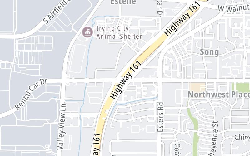
This junction is located in Irving.
This location is in the Dallas - Fort Worth area.
This location's approximate GPS Coordinates are 32.85729 x -97.01278.
Which directions can I travel from here?
From this junction, traffic can enter traveling both westbound and eastbound. Traffic can also exit traveling both westbound and eastbound.
On to W Walnut Hill Lane, about 0.9 miles away ►
◄ Back to SH 183 / Airport Freeway, about 1.4 miles away.
Which direction are tolls charged here?
Tolls are not charged or collected at this junction.
Above: Map image © TomTom Intl BVThe interactive map and lists on this page include key traveler services within two miles of this destination point.
You will find common services, including gas stations, truck stops, EV charging facilities, fast-food or family restaurants, and hotels. These are displayed on the interactive map as markers, which you can select for more information.
Current driving conditions and weather, along with a more complete list of key services, may be found below the map.

Mostly Cloudy
80°F / 26.4°C
Feels Like:
79°F / 26°C
Visibility
9 Mi / 14.5 Km
3-Hour Precip:
0 In / 0.0 Cm
South
Winds (S)
10.5 MPH / 16.9 KPH
Gusts:
21.3 MPH / 34.3 KPH
▸ Get the full forecast for This Location | The Dallas - Fort Worth area
Conditions and forecasts provided in partnership with AccuWeather.

Weather provided in partnership with AccuWeather.

SH183 @ SH161 (PGBT)
Camera Direction: NORTH. Source: TXDOT - Dallas Fort Worth 75061
Cameras Closest To Northgate Drive
1.45 Mi
1.63 Mi

2.24 Mi
2.26 Mi
2.87 Mi
There are no currently-available photos for this location.
The map above shows all services within about a two (2) mile radius.

Destination Travel

Closest Gas Stations
VALERO
3950 Valley View Lane • 0.46 miles
Store/Fuel Brand: Valero
GULF
5075 West Northgate Drive • 0.46 miles
Store/Fuel Brand: Gulf
VALERO
3950 Valley View Lane • 0.46 miles
Store/Fuel Brand: Valero
VALERO
3700 Cheyenne Street • 0.67 miles
Store/Fuel Brand: Valero
Closest EV Chargers
WEST IRVING LIBRARY
4444 West Rochelle Road • 0.85 miles
CONNECTOR: IEC62196Type1
POWER: 8 KW @ 264 V
CURRENT: 32 Amp AC1
CHARGEPOINT
2400 Aviation Drive • 1.43 miles
CONNECTOR: IEC62196Type1
POWER: 6 KW @ 240 V
CURRENT: 27 Amp AC1
IRVING - SUPERCHARGER
3575 Story Road West • 1.44 miles
CONNECTOR: Tesla
POWER: 250 KW @ 400 V
CURRENT: 625 Amp DC
CHARGEPOINT
2400 Aviation Drive • 1.51 miles
CONNECTOR: IEC62196Type1
POWER: 6 KW @ 240 V
CURRENT: 27 Amp AC1

Closest Fast Food
Fast food refers ONLY to quick-service and take-out diners. All restaurant types are shown on the map above.
KRISPY KRUNCHY CHICKEN
5075 West Northgate Drive • 0.46 miles
MASITA GRILL
3718 Portland Street • 0.50 miles
MOMOSTOP
3635 North Belt Line Road • 1.16 miles
LITTLE CAESARS
3981 North Belt Line Road • 1.18 miles
COUSIN'S BBQ
East 31st Street • 1.21 miles
POPEYES
3200 East Airfield Drive • 1.22 miles
BURGER STREET
3401 North Belt Line Road • 1.24 miles
TACO BELL
3321 North Belt Line Road • 1.24 miles
Journey to key destinations around and adjacent to Texas!
Communities in this metro area include Dallas, Fort Worth, Plano, Addison, Frisco, Grand Prairie, Arlington, Carrrollton, and Lake Dallas.
Individual toll maps for this region are listed below.
Communities in this metro area include Houston, Humble, Tomball, Sugar Land, Galveston, Pearland, and Katy.
Individual toll maps for this region are listed below.
Communities in this metro area include Austin, Pflugerville, Round Rock, Georgetown, Cedar Park, Mustang Ridge, Manor, Serenada, Sunset Valley, and Hutto.
Individual toll maps for this region are listed below.
Communities in this metro area include Tyler, Wood Springs, Noonday, and Whitehouse.
Individual toll maps for this region are listed below.

Communities in this metro area include Brownsville, Heroica Matamoros, Tamaulipas, San Benito, Harlingen, and Rancho Viejo.
Individual toll maps for this region are listed below.

Communities in this metro area include Lawton, Fort Sill, Geronimo, and Cache.
Individual toll maps for this region are listed below.


 Addison Airport Toll Tunnel ▹
 Chisholm Trail Parkway ▹
 Dallas North Tollway ▹
 Lewisville Lake Toll Bridge ▹
 Mountain Creek Lake Toll Bridge ▹
 President George Bush Turnpike ▹
 Sam Rayburn Tollway ▹
 360 Tollway ▹
 Grand Parkway ▹
 Hardy Toll Road ▹
 Sam Houston Tollway ▹
 Tomball Tollway ▹
 Westpark Tollway ▹
 Loop 1 ▹
 SH 130 ▹
 SH 45 N ▹
 SH 45 SW ▹
 183A Toll Road ▹
 183 Toll Road ▹
 290 Toll Road ▹
 71 Toll Road ▹
 Toll 49 ▹
 SH 550 ▹
 H E Bailey Turnpike ▹


