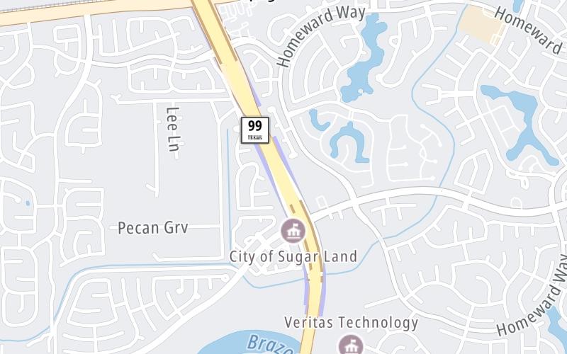
Grand Parkway At New Territory Toll Gantry

New Territory Toll Gantry

At A Glance

This toll plaza is located in Sugar Land. Richmond is nearby.

This location is in the Houston - Galveston area.

▾ Interactive Map Below ▾

This location's approximate GPS Coordinates are 29.59222 x -95.67938.

The next exit is Sandhill Drive / to US 90A, approximately 0.5 miles away ►

◄ The previous exit is New Territory Boulevard, approximately 0.2 miles away.

Which direction are tolls charged here?

Tolls are not charged or collected at this toll plaza.

▾ Travel Conditions ▾

Above: Map image © TomTom Intl BV

Using The POI Map

The interactive map will help you orient this location in relationship to other junctions.

Current driving conditions and weather may also be found below the map.

View Map ▾Weather ▾

Static map of Grand Parkway at New Territory Toll Gantry
Static map. Interactive map is below.

Because of the nature of this location, no services are displayed. On most exit or junction pages, a summary of the closest services around the junction will be shown, along with detailed lists of services within two miles.

View Map ▾

Advertising
Advertising

Interactive Exit Map Of Grand Parkway

Your Selected Location Relative To Roadway

Advertising
Advertising

Travel Conditions At New Territory Toll Gantry

Current Weather And Visibility

  • 15 7 10
  • Sunny

    75°F / 23.9°C

    Feels Like:

    85°F / 29.2°C

  • Visibility

    9 Mi / 14.5 Km

    3-Hour Precip:

    0 In / 0.0 Cm

  • North
    Winds (N)

    0 MPH / 0 KPH

    Gusts:

    0 MPH / 0 KPH

▸ Get the full forecast for the Houston - Galveston area

Available Cameras

IH-69 SOUTHWEST @ SOUTH OF UNIVERSITY

IH-69 SOUTHWEST @ SOUTH OF UNIVERSITY

Camera Direction: WEST. Source: TXDOT - Houston 77479

Cameras Closest To New Territory Toll Gantry

Camera Direction: WEST. Source: TXDOT - Houston 77479

1.75 Mi

Camera Direction: WEST. Source: TXDOT - Houston 77479

1.96 Mi

Camera Direction: EAST. Source: TXDOT - Houston 77479

2.05 Mi

Travel Pictures

No photos …

There are no currently-available photos for this location.

Advertising
Advertising

EXPLORE TEXAS

Journey to key destinations around and adjacent to Texas!

Map Of This Region ▹

Communities in this metro area include Dallas, Fort Worth, Plano, Addison, Frisco, Grand Prairie, Arlington, Carrrollton, and Lake Dallas.

Individual toll maps for this region are listed below.

Map Of This Region ▹

Communities in this metro area include Houston, Humble, Tomball, Sugar Land, Galveston, Pearland, and Katy.

Individual toll maps for this region are listed below.

Map Of This Region ▹

Communities in this metro area include Austin, Pflugerville, Round Rock, Georgetown, Cedar Park, Mustang Ridge, Manor, Serenada, Sunset Valley, and Hutto.

Individual toll maps for this region are listed below.

Map Of This Region ▹

Communities in this metro area include Tyler, Wood Springs, Noonday, and Whitehouse.

Individual toll maps for this region are listed below.

Map Of This Region ▹

Communities in this metro area include Brownsville, Heroica Matamoros, Tamaulipas, San Benito, Harlingen, and Rancho Viejo.

Individual toll maps for this region are listed below.

Map Of This Region ▹

Communities in this metro area include Lawton, Fort Sill, Geronimo, and Cache.

Individual toll maps for this region are listed below.

Advertising
Advertising
Turnpikes.com is proud to partner with the following: