Pennsylvania Turnpike At Toll Gantry T 031

Toll Gantry T 031

At A Glance

This toll point is located in Mars. This gantry is not yet active/online.

This location is in the Pittsburgh - Western Pennsylvania area.

▾ Interactive Map Below ▾

This location's approximate GPS Coordinates are 40.65364 x -80.06442.

On to PA 8 / William Flynn Hwy, about 7.7 miles away ►

◄ Back to Warrendale Toll Plaza, about 0.4 miles away.

▾ Travel Conditions ▾

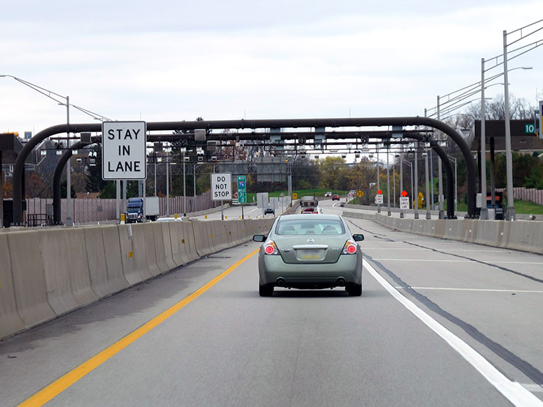
Above: Photo by Turnpikes.com

Using The POI Map

The interactive map will help you orient this location in relationship to other junctions.

Current driving conditions and weather may also be found below the map.

View Map ▾Weather ▾

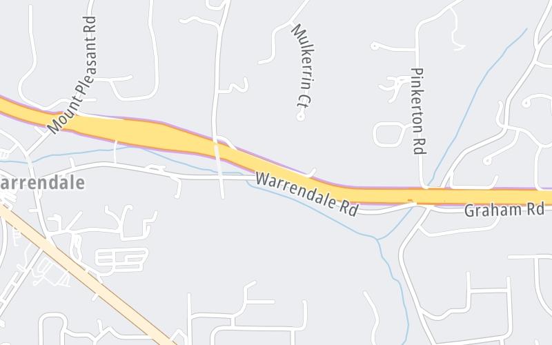
Static map of Pennsylvania Turnpike at Toll Gantry T 031
Static map. Interactive map is below.

Because of the nature of this location, no services are displayed. On most exit or junction pages, a summary of the closest services around the junction will be shown, along with detailed lists of services within two miles.

View Map ▾

Advertising
Advertising

Interactive Exit Map Of Pennsylvania Turnpike

Your Selected Location Relative To Roadway

Advertising
Advertising

Travel Conditions At Toll Gantry T 031

Current Weather And Visibility

  • 04 7 01
  • Clear

    -1°F / -18.5°C

    Feels Like:

    F / -17.7°C

  • Visibility

    11 Mi / 17.7 Km

    3-Hour Precip:

    0 In / 0.0 Cm

  • West Northwest
    Winds (WNW)

    3.2 MPH / 5.2 KPH

    Gusts:

    8.5 MPH / 13.6 KPH

▸ Get the full forecast for the Pittsburgh - Western Pennsylvania area

Available Cameras

I-79 @ EXIT 76 (US 9 NORTH CRANBERRY)

I-79 @ EXIT 76 (US 9 NORTH CRANBERRY)

Camera Direction: NORTH. Source: PennDOT - Pittsburgh 15090

Cameras Closest To Toll Gantry T 031

Camera Direction: NORTH. Source: PennDOT - Pittsburgh 15090

1.60 Mi

Camera Direction: UNKNOWN. Source: PennDOT - Pittsburgh 15090

1.63 Mi

Camera Direction: SOUTH. Source: PennDOT - Philadelphia 15090

1.93 Mi

Camera Direction: NORTH. Source: PennDOT - Philadelphia 16046

2.06 Mi

Camera Direction: SOUTH. Source: PennDOT - Philadelphia 16066

2.39 Mi

Travel Pictures

Pictures Around Toll Gantry T 031

About this photo:
Overhead tolling and photographic equipment can be seen as drivers pass westbound beneath a toll gantry at the Warrendale Plaza. Construction barriers can be seen where crews have separated old toll lanes from new, as this photo was taken mid-way during the conversion from toll booths to cashless tolling. This gantry falls at exactly mile marker 31.0 on the PA Turnpike.;

Photo taken 11-01-2019

More Pictures Near Toll Gantry T 031

Photo taken 11-01-2019
Photo taken 05-14-2012
Advertising
Advertising

EXPLORE PENNSYLVANIA

Journey to key destinations around and adjacent to Pennsylvania!

Map Of This Region ▹

Communities in this metro area include Pittsburgh, Cranberry Township, Beaver Valley, New Castle, Washington, Uniontown, Cheat Lake, West Virginia, Boardman, Ohio, and Youngstown, Ohio.

Individual toll maps for this region are listed below.

Map Of This Region ▹

Communities in this metro area include Harrisburg, Mechanicsburg, Carlisle, Hershey, and York.

Individual toll maps for this region are listed below.

Map Of This Region ▹

Communities in this metro area include Philadelphia, King Of Prussia, Valley Forge, West Chester, Bristol, Burlington, New Jersey, Morrisville, Trenton, New Jersey, Palmyra, New Jersey, Wilmington, Delaware, and Camden, New Jersey.

Individual toll maps for this region are listed below.

Map Of This Region ▹

Communities in this metro area include Scranton, Wilkes Barre, Stroudsburg, Clarks Summit, and Knowlton Township, New Jersey.

Individual toll maps for this region are listed below.

Map Of This Region ▹

Communities in this metro area include Camden, Burlington, Palmyra, Pennsauken, Cherry Hill, Gloucester City, Trenton, Wilmington, Delaware, Philadelphia, Pennsylvania, Tacony, Pennsylvania, and Bristol, Pennsylvania.

Individual toll maps for this region are listed below.

Map Of This Region ▹

Communities in this metro area include Knowlton Township, Trenton, Phillipsburg, Easton, Pennsylvania, Lambertville, Ewing, Morrisville, Pennsylvania, and Stroudsburg, Pennsylvania.

Individual toll maps for this region are listed below.

Map Of This Region ▹

Communities in this metro area include Cleveland, Akron, Boardman, Lorain, Aurora, Youngstown, New Castle, Pennsylvania, and Beaver Falls, Pennsylvania.

Individual toll maps for this region are listed below.

Advertising
Advertising
Turnpikes.com is proud to partner with the following: