Map & services within two (2) miles
Interactive map shows available cameras, plus nearby fuel, food and lodging


See below for more about this area
Interactive map shows available cameras, plus nearby fuel, food and lodging
See below for more about this area
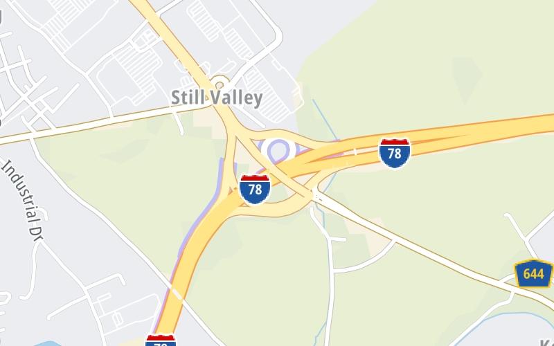
This is Exit 3 of the I78 Toll Bridge.
This junction is located in Greenwich Township. Phillipsburg is nearby. NOTE: I–78 continues as Phillipsburg–Newark Expy.
This location is in the Scranton - Wilkes Barre - Allentown area; it also overlaps with the Northwestern New Jersey - Allentown area.
This location's approximate GPS Coordinates are 40.66991 x -75.13474.
Which directions can I travel from here?
From this junction, traffic can enter traveling both westbound and eastbound. Traffic can also exit traveling both westbound and eastbound.
◄ Back to PA Welcome Center / I 78 W, about 5.2 miles away.
This location also connects with New Jersey.
Which direction are tolls charged here?
Tolls are not charged or collected at this junction.
Above: Map image © TomTom Intl BVThe interactive map and lists on this page include key traveler services within two miles of this destination point.
You will find common services, including gas stations, truck stops, EV charging facilities, fast-food or family restaurants, and hotels. These are displayed on the interactive map as markers, which you can select for more information.
Current driving conditions and weather, along with a more complete list of key services, may be found below the map.

Mostly Sunny
46°F / 7.5°C
Feels Like:
50°F / 10.3°C
Visibility
14 Mi / 22.5 Km
3-Hour Precip:
0 In / 0.0 Cm
North Northwest
Winds (NNW)
7.8 MPH / 12.6 KPH
Gusts:
14.8 MPH / 23.9 KPH
▸ Get the full forecast for This Location | The Scranton - Wilkes Barre - Allentown area
Conditions and forecasts provided in partnership with AccuWeather.

Weather provided in partnership with AccuWeather.
There is no currently-available traffic camera feed for this location.
There are no currently-available photos for this location.
The map above shows all services within about a two (2) mile radius.

Destination Travel

Closest Gas Stations
CONOCO
1312 US Highway 22 • 0.46 miles
Store/Fuel Brand: Conoco
FUEL ONE
1307 US Highway 22 • 0.49 miles
Store/Fuel Brand:
WAWA
• 0.56 miles
Store/Fuel Brand: Wawa
WAWA FOOD MARKET
1300 US Highway 22 • 0.61 miles
Store/Fuel Brand: Wawa Food Market
Closest EV Chargers
PHILLIPSBURG - EASTON HONDA - DCFC
400 3rd Avenue • 1.11 miles
CONNECTOR: IEC62196Type1CCS
POWER: 60 KW @ 1000 V
CURRENT: 150 Amp DC

Closest Fast Food
Fast food refers ONLY to quick-service and take-out diners. All restaurant types are shown on the map above.
CHIPOTLE
1314 US Highway 22 • 0.40 miles
WAWA
1300 US Highway 22 • 0.54 miles
AUNTIE ANNE'S
1300 Us Highway 22 • 0.60 miles
WHITE CASTLE
1236 US Highway 22 • 0.62 miles
MCDONALD'S
1215 US Highway 22 • 0.72 miles
BURGER KING
1232 US Highway 22 • 0.92 miles
KRISPY KRUNCHY CHICKEN
327 3rd Avenue • 1.26 miles
PANERA BREAD
1196 US Highway 22 • 1.27 miles
Journey to key destinations around and adjacent to Pennsylvania!
Communities in this metro area include Pittsburgh, Cranberry Township, Beaver Valley, New Castle, Washington, Uniontown, Cheat Lake, West Virginia, Boardman, Ohio, and Youngstown, Ohio.
Individual toll maps for this region are listed below.
Communities in this metro area include Harrisburg, Mechanicsburg, Carlisle, Hershey, and York.
Individual toll maps for this region are listed below.
Communities in this metro area include Philadelphia, King Of Prussia, Valley Forge, West Chester, Bristol, Burlington, New Jersey, Morrisville, Trenton, New Jersey, Palmyra, New Jersey, Wilmington, Delaware, and Camden, New Jersey.
Individual toll maps for this region are listed below.

Roads Within Region
Communities in this metro area include Scranton, Wilkes Barre, Stroudsburg, Clarks Summit, and Knowlton Township, New Jersey.
Individual toll maps for this region are listed below.
Communities in this metro area include Camden, Burlington, Palmyra, Pennsauken, Cherry Hill, Gloucester City, Trenton, Wilmington, Delaware, Philadelphia, Pennsylvania, Tacony, Pennsylvania, and Bristol, Pennsylvania.
Individual toll maps for this region are listed below.

Roads Within Region
Communities in this metro area include Knowlton Township, Trenton, Phillipsburg, Easton, Pennsylvania, Lambertville, Ewing, Morrisville, Pennsylvania, and Stroudsburg, Pennsylvania.
Individual toll maps for this region are listed below.
Communities in this metro area include Cleveland, Akron, Boardman, Lorain, Aurora, Youngstown, New Castle, Pennsylvania, and Beaver Falls, Pennsylvania.
Individual toll maps for this region are listed below.

 PA Turnpike 66 ▹
 Beaver Valley Expressway ▹
 Mon Fayette Expressway ▹
 Pennsylvania Turnpike ▹
 Ohio Turnpike ▹
 PA Turnpike 576 ▹
 Delaware Memorial Bridge ▹
 Delaware Turnpike ▹
 Atlantic City Expressway ▹
 New Jersey Turnpike ▹
 Benjamin Franklin Bridge ▹
 Walt Whitman Bridge ▹
 Commodore Barry Bridge ▹
 Betsy Ross Bridge ▹
 Scudder Falls Toll Bridge ▹
 Trenton Morrisville Toll Bridge ▹
 Tacony Palmyra Bridge ▹
 Burlington Bristol Bridge ▹
 Milford Montague Toll Bridge ▹
 Delaware Water Gap Toll Bridge ▹
 Portland Columbia Toll Bridge ▹
 Easton Phillipsburg Toll Bridge ▹
 I78 Toll Bridge ▹
 Garden State Parkway ▹
 New Hope Lambertville Toll Bridge ▹