Map & services within two (2) miles
Interactive map shows available cameras, plus nearby fuel, food and lodging


See below for more about this area
Interactive map shows available cameras, plus nearby fuel, food and lodging
See below for more about this area
This is Exit 1B of PA Turnpike 576.
This junction is located in Findlay Township. Moon Township is nearby. NOTE: Shared ramp with Exit 1B eastbound to Pittsburgh.
This location is in the Pittsburgh - Western Pennsylvania area.
This location's approximate GPS Coordinates are 40.48869 x -80.26328.
Which directions can I travel from here?
From this junction, traffic can enter traveling both and eastbound. Traffic can only exit going westbound.
On to I–376 / Airport Expy, about 0.1 miles away ►
Which direction are tolls charged here?
Tolls are not charged or collected at this junction.
Above: Photo by Turnpikes.comThe interactive map and lists on this page include key traveler services within two miles of this destination point.
You will find common services, including gas stations, truck stops, EV charging facilities, fast-food or family restaurants, and hotels. These are displayed on the interactive map as markers, which you can select for more information.
Current driving conditions and weather, along with a more complete list of key services, may be found below the map.

Mostly Cloudy
43°F / 6.1°C
Feels Like:
41°F / 5.1°C
Visibility
10 Mi / 16.1 Km
3-Hour Precip:
0 In / 0.0 Cm
North
Winds (N)
8.1 MPH / 13 KPH
Gusts:
8.1 MPH / 13 KPH
▸ Get the full forecast for This Location | The Pittsburgh - Western Pennsylvania area
Conditions and forecasts provided in partnership with AccuWeather.

Weather provided in partnership with AccuWeather.

I-376
Camera Direction: WEST. Source: PennDOT - Philadelphia 15108
Cameras Closest To Pittsburgh International / PIT
2.47 Mi
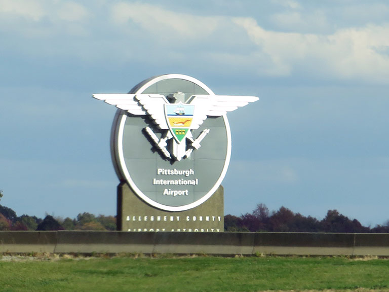
About this photo:
Drivers heading into Pittsburgh International Airport are greeted by a large eagle bearing a shield adorned with an old-world crest, courtesy of the Allegheny County Airport Authority. This shot is the sign as seen by drivers exiting the Southern Beltway via the ramp to I-376 westbound.
Photo taken 10-17-2022
The map above shows all services within about a two (2) mile radius.

Destination Travel

Closest Fast Food
Fast food refers ONLY to quick-service and take-out diners. All restaurant types are shown on the map above.
MCDONALD'S
Airport Boulevard • 0.58 miles
AUNTIE ANNE'S
1000 Airport Boulevard • 0.62 miles
AROMA STONE HEARTH PIZZA
1246 Route 30 • 1.62 miles
Journey to key destinations around and adjacent to Pennsylvania!
Communities in this metro area include Pittsburgh, Cranberry Township, Beaver Valley, New Castle, Washington, Uniontown, Cheat Lake, West Virginia, Boardman, Ohio, and Youngstown, Ohio.
Individual toll maps for this region are listed below.
Communities in this metro area include Harrisburg, Mechanicsburg, Carlisle, Hershey, and York.
Individual toll maps for this region are listed below.
Communities in this metro area include Philadelphia, King Of Prussia, Valley Forge, West Chester, Bristol, Burlington, New Jersey, Morrisville, Trenton, New Jersey, Palmyra, New Jersey, Wilmington, Delaware, and Camden, New Jersey.
Individual toll maps for this region are listed below.

Roads Within Region
Communities in this metro area include Scranton, Wilkes Barre, Stroudsburg, Clarks Summit, and Knowlton Township, New Jersey.
Individual toll maps for this region are listed below.
Communities in this metro area include Camden, Burlington, Palmyra, Pennsauken, Cherry Hill, Gloucester City, Trenton, Wilmington, Delaware, Philadelphia, Pennsylvania, Tacony, Pennsylvania, and Bristol, Pennsylvania.
Individual toll maps for this region are listed below.

Roads Within Region
Communities in this metro area include Knowlton Township, Trenton, Phillipsburg, Easton, Pennsylvania, Lambertville, Ewing, Morrisville, Pennsylvania, and Stroudsburg, Pennsylvania.
Individual toll maps for this region are listed below.
Communities in this metro area include Cleveland, Akron, Boardman, Lorain, Aurora, Youngstown, New Castle, Pennsylvania, and Beaver Falls, Pennsylvania.
Individual toll maps for this region are listed below.


 PA Turnpike 66 ▹
 Beaver Valley Expressway ▹
 Mon Fayette Expressway ▹
 Pennsylvania Turnpike ▹
 Ohio Turnpike ▹
 PA Turnpike 576 ▹
 Delaware Memorial Bridge ▹
 Delaware Turnpike ▹
 Atlantic City Expressway ▹
 New Jersey Turnpike ▹
 Benjamin Franklin Bridge ▹
 Walt Whitman Bridge ▹
 Commodore Barry Bridge ▹
 Betsy Ross Bridge ▹
 Scudder Falls Toll Bridge ▹
 Trenton Morrisville Toll Bridge ▹
 Tacony Palmyra Bridge ▹
 Burlington Bristol Bridge ▹
 Milford Montague Toll Bridge ▹
 Delaware Water Gap Toll Bridge ▹
 Portland Columbia Toll Bridge ▹
 Easton Phillipsburg Toll Bridge ▹
 I78 Toll Bridge ▹
 Garden State Parkway ▹
 New Hope Lambertville Toll Bridge ▹