Sumner & Callahan Tunnels Map

Advertising
Advertising

Exits Map For The Sumner & Callahan Tunnels

This map of the Sumner & Callahan Tunnels displays markers for exits and tolling points, which you can select to get a close-up map of that point of interest or location.

The points-of-interest shown on this map are also listed below, ordered from south to north.

See below for more comprehensive information about the Sumner & Callahan Tunnels

Advertising
Advertising
Static map a segment of the Sumner & Callahan Tunnels

A Quick Look At The Sumner & Callahan Tunnels

Mass Route 1A is another name used for this tunnel. This tunnel toll road serves Boston.

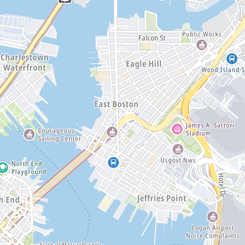
The fixed map seen here presents a quick view of The Sumner & Callahan Tunnels and surrounding area. The fully-interactive map of The Sumner & Callahan Tunnels abvoe includes linked markers. You may resize and reposition the interactive map to orient the road in relation to other landmarks.

There is also a complete list of exits below.

View Map Exit / POI List

Advertising
Advertising

What Does It Cost To Use The Sumner & Callahan Tunnels?

Tolls For Cars, SUVs, Pickups, etc.

▹ Toll as of October 2016.

The total toll for using the Sumner & Callahan Tunnels is $1.75, if you are using a compatible transponder, RFID sticker or other pass.

Transponders You Can Use

For drivers paying with a transponder, the following passes will work on the Sumner & Callahan Tunnels

  • e-zpass
  • epass xtra
  • i-pass
  • quick pass
  • riverlink
  • sunpass pro
  • uni

Learn about transponders and accounts in Massachusetts.

Without a compatible pass or transponder, the toll will be $2.05.

View MapAll Tolls / Calculator ▸

Our new toll and trip calculator is being constructed. For most roads, you can still use the legacy calculator for current, accurate tolls.

Discover Massachusetts Attractions

Turnpikes.com has partnered with Tiqets.com to bring you these excusive deals on attractions!

Advertising
Advertising

List Of Exits / Points Of Interest For The Sumner & Callahan Tunnels

Select an exit or other location to get a separate map, including locations of available gas, EV charging, fast-food and other dining options, plus current weather and driving conditions.

Sumner Tunnel exit

Sumner Tunnel exit — Boston

View Map & Info

▸ GPS 42.362605000 X -71.055064000
NOTES: 1A SB / Sumner Tunnel exit points

MassDOT Massachusetts Department of Transportation manages this segment.

Callahan Tunnel entrance

Callahan Tunnel entrance — Boston

View Map & Info

▸ GPS 42.362301000 X -71.054342000
NOTES: 1A NB / Callahan Tunnel access points

MassDOT Massachusetts Department of Transportation manages this segment.

Sumner Tunnel toll gantry

Sumner Tunnel toll gantry — Boston

View Map & Info

▸ GPS 42.373289000 X -71.038468000
NOTES: SB toll gantry

MassDOT Massachusetts Department of Transportation manages this segment.

Callahan Tunnel toll gantry

Callahan Tunnel toll gantry — Boston

View Map & Info

▸ GPS 42.373177000 X -71.038296000
NOTES: NB toll gantry

MassDOT Massachusetts Department of Transportation manages this segment.

Sumner Tunnel entrance

Sumner Tunnel entrance — Boston

View Map & Info

▸ GPS 42.373628000 X -71.038015000
NOTES: 1A SB / Sumner Tunnel access points

MassDOT Massachusetts Department of Transportation manages this segment.

Callahan Tunnel exit

Callahan Tunnel exit — Boston

View Map & Info

▸ GPS 42.373371000 X -71.038026000
NOTES: 1A NB / Callahan Tunnel exit points

MassDOT Massachusetts Department of Transportation manages this segment.

Advertising
Advertising

EXPLORE MASSACHUSETTS

Journey to key destinations around and adjacent to Massachusetts!

Map Of This Region ▹

Communities in this metro area include Boston, Cambridge, Chelsea, Allston, Framingham, Westborough, and Worcester.

Individual toll maps for this region are listed below.

Map Of This Region ▹

Communities in this metro area include Springfield, West Springfield, Chicopee, Westfield, and Hartford, Connecticut.

Individual toll maps for this region are listed below.

Map Of This Region ▹

Communities in this metro area include Hooksett, Concord, Manchester, and West Concord.

Individual toll maps for this region are listed below.

Map Of This Region ▹

Communities in this metro area include Albany, Schenectady, Rotterdam, Amsterdam, and West Stockbridge, Massachusetts.

Individual toll maps for this region are listed below.

Advertising
Advertising
Turnpikes.com is proud to partner with the following: