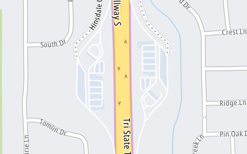
Map & services within two (2) miles
Interactive map shows available cameras, plus nearby fuel, food and lodging


See below for more about this area
Interactive map shows available cameras, plus nearby fuel, food and lodging
See below for more about this area
This travel plaza is located in Hinsdale. La Grange is nearby.
This location is in the Chicagoland - Northwestern Indiana area.
This location's approximate GPS Coordinates are 41.78348 x -87.90786.
On to I–55, about 0.9 miles away ►
◄ Back to East Ogden Avenue/US 34, about 2.5 miles away.
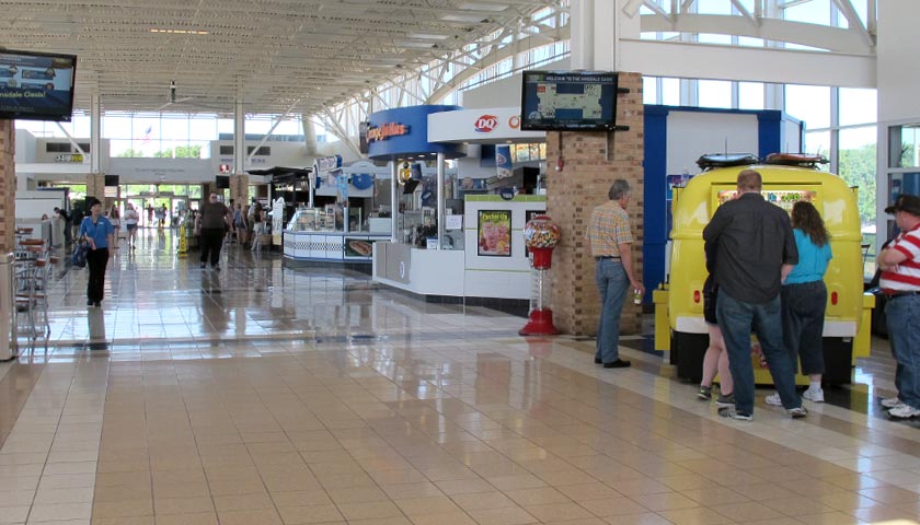
Above: Photo by Turnpikes.comThe interactive map and lists on this page include key traveler services within two miles of this destination point.
You will find common services, including gas stations, truck stops, EV charging facilities, fast-food or family restaurants, and hotels. These are displayed on the interactive map as markers, which you can select for more information.
Current driving conditions and weather, along with a more complete list of key services, may be found below the map.

Partly Sunny
35°F / 1.4°C
Feels Like:
33°F / 0.3°C
Visibility
10 Mi / 16.1 Km
3-Hour Precip:
0.02 In / 0.1 Cm
Northwest
Winds (NW)
3.4 MPH / 5.5 KPH
Gusts:
9 MPH / 14.5 KPH
▸ Get the full forecast for This Location | The Chicagoland - Northwestern Indiana area
Conditions and forecasts provided in partnership with AccuWeather.

Weather provided in partnership with AccuWeather.
There is no currently-available traffic camera feed for this location.
About this photo:
Photo taken 07-04-2014
The map above shows all services within about a two (2) mile radius.

Destination Travel

Closest Gas Stations
MOBIL
5500 Wolf Road • 0.65 miles
Store/Fuel Brand: Mobil
SHELL
5500 Wolf Road • 0.65 miles
Store/Fuel Brand: Shell
SPEEDLANE
1422 West 55th Street • 1.14 miles
Store/Fuel Brand: Shell
MOBIL
6700 Joliet Road • 1.36 miles
Store/Fuel Brand: Mobil
Closest EV Chargers
CHARGEPOINT
803 Joliet Road • 1.64 miles
CONNECTOR: IEC62196Type1
POWER: 6 KW @ 240 V
CURRENT: 27 Amp AC1
CHARGEPOINT
5800 Tri State Toll Road • 326 feet
CONNECTOR: IEC62196Type1
POWER: 6 KW @ 240 V
CURRENT: 27 Amp AC1
HINSDALE OASIS SOUTH BOUND
5800 Tri-State Tollway • 334 feet
CONNECTOR: IEC62196Type1
POWER: 6 KW @ 240 V
CURRENT: 27 Amp AC1

Closest Fast Food
Fast food refers ONLY to quick-service and take-out diners. All restaurant types are shown on the map above.
DOMINO'S
6555 Willow Springs Road • 1.39 miles
CAFE LA FORTUNA
46 Village Place • 1.67 miles
TONI PATISSERIE & CAFE
51 South Washington Street • 1.68 miles
EINSTEIN BROTHERS BAGELS
54 South Washington Street • 1.68 miles
TACO BELL
• 116 feet
MCDONALD'S
5800 Hinsdale Oasis Tri-State 294 • 130 feet
AUNTIE ANNE'S
5800 Tri State Toll Road • 131 feet
PANDA EXPRESS
• 166 feet
Journey to key destinations around and adjacent to Illinois!
Communities in this metro area include Chicago, Aurora, Oak Lawn, Des Plaines, Waukegan, Highland Park, Gary, Indiana, Schaumburg, Naperville, Oak Brook, and Joliet.
Individual toll maps for this region are listed below.
Communities in this metro area include Gary, South Bend, Elkhart, Portage, and Fremont.
Individual toll maps for this region are listed below.

 Chicago Skyway ▹
 Jane Addams Memorial Tollway ▹
 Ronald Reagan Memorial Tollway ▹
 Tri State Tollway ▹
 Veterans Memorial Tollway ▹
 Cline Avenue Bridge ▹
 Houbolt Road Extension ▹
 Indiana Toll Road ▹
 Ohio Turnpike ▹


