Map & services within two (2) miles
Interactive map shows available cameras, plus nearby fuel, food and lodging


See below for more about this area
Interactive map shows available cameras, plus nearby fuel, food and lodging
See below for more about this area
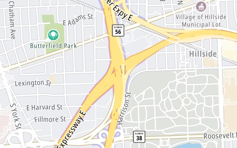
This is Exit 32 of the Tri State Tollway.
This junction is located in Chicago. Hillside is nearby. NOTE: SB I–294 to WB I–88/WB I–88 to NB I–294.
This location is in the Chicagoland - Northwestern Indiana area.
This location's approximate GPS Coordinates are 41.86932 x -87.91709.
Which directions can I travel from here?
From this junction, traffic can enter traveling both southbound and northbound. Traffic can also exit traveling both southbound and northbound.
On to Roosevelt Road/IL 38, about 0.5 miles away ►
◄ Back to I–290, about 0.6 miles away.
▹ The Tri State Tollway and the Ronald Reagan Memorial Tollway connect here.
Which direction are tolls charged here?
Tolls are not charged or collected at this junction.
Above: Map image © TomTom Intl BVThe interactive map and lists on this page include key traveler services within two miles of this destination point.
You will find common services, including gas stations, truck stops, EV charging facilities, fast-food or family restaurants, and hotels. These are displayed on the interactive map as markers, which you can select for more information.
Current driving conditions and weather, along with a more complete list of key services, may be found below the map.

Cloudy
40°F / 4.5°C
Feels Like:
42°F / 5.8°C
Visibility
10 Mi / 16.1 Km
3-Hour Precip:
0 In / 0.0 Cm
North Northwest
Winds (NNW)
4.5 MPH / 7.2 KPH
Gusts:
7.8 MPH / 12.6 KPH
▸ Get the full forecast for This Location | The Chicagoland - Northwestern Indiana area
Conditions and forecasts provided in partnership with AccuWeather.

Weather provided in partnership with AccuWeather.
There is no currently-available traffic camera feed for this location.
There are no currently-available photos for this location.
The map above shows all services within about a two (2) mile radius.

Destination Travel

Closest Gas Stations
SHELL
218 East Butterfield Road • 0.82 miles
Store/Fuel Brand: Shell
BP
217 East Butterfield Road • 0.86 miles
Store/Fuel Brand: BP
HILLSIDE SHELL
4750 Roosevelt Road • 0.91 miles
Store/Fuel Brand: Shell
MARATHON
4804 Butterfield Road • 0.93 miles
Store/Fuel Brand: Marathon
Closest EV Chargers
CHARGEPOINT
300 Windsor Drive • 1.23 miles
CONNECTOR: IEC62196Type1
POWER: 6 KW @ 240 V
CURRENT: 27 Amp AC1
CHARGEPOINT
2011 York Road • 1.46 miles
CONNECTOR: IEC62196Type1
POWER: 6 KW @ 240 V
CURRENT: 27 Amp AC1
CHARGEPOINT
2001 Hub Group Way • 1.49 miles
CONNECTOR: IEC62196Type1
POWER: 6 KW @ 240 V
CURRENT: 27 Amp AC1
OAK BROOK POINTE, LLC
700 Commerce Drive • 1.62 miles
CONNECTOR: IEC62196Type1
POWER: 6 KW @ 208 V
CURRENT: 30 Amp AC1

Closest Fast Food
Fast food refers ONLY to quick-service and take-out diners. All restaurant types are shown on the map above.
JIMMY JOHN'S
1035 South York Street • 0.83 miles
DOMINO'S
1036 South York Street • 0.91 miles
MCDONALD'S
190 East Butterfield Road • 0.92 miles
BURGER KING
176 East Butterfield Road • 0.95 miles
MCDONALD'S
5707 Saint Charles Road • 1.39 miles
CHICKIES BEEF
1801 South Wolf Road • 1.40 miles
SOUTHTOWN HOT DOGS
103 East Vallette Street • 1.52 miles
ELIJAHS SPECIALTY COFFEE & TEA
136 West Vallette Street • 1.57 miles
Journey to key destinations around and adjacent to Illinois!
Communities in this metro area include Chicago, Aurora, Oak Lawn, Des Plaines, Waukegan, Highland Park, Gary, Indiana, Schaumburg, Naperville, Oak Brook, and Joliet.
Individual toll maps for this region are listed below.
Communities in this metro area include Gary, South Bend, Elkhart, Portage, and Fremont.
Individual toll maps for this region are listed below.
 Chicago Skyway ▹
 Jane Addams Memorial Tollway ▹
 Ronald Reagan Memorial Tollway ▹
 Tri State Tollway ▹
 Veterans Memorial Tollway ▹
 Cline Avenue Bridge ▹
 Houbolt Road Extension ▹
 Indiana Toll Road ▹
 Ohio Turnpike ▹


