Map & services within two (2) miles
Interactive map shows available cameras, plus nearby fuel, food and lodging


See below for more about this area
Interactive map shows available cameras, plus nearby fuel, food and lodging
See below for more about this area
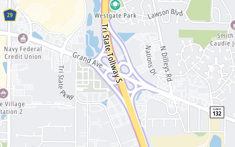
This is Exit 8 of the Tri State Tollway.
This junction is located in Gurnee. Newport and Waukegan are nearby.
This location is in the Chicagoland - Northwestern Indiana area.
This location's approximate GPS Coordinates are 42.38099 x -87.94745.
Which directions can I travel from here?
From this junction, traffic can enter traveling both southbound and northbound. Traffic can also exit traveling both southbound and northbound.
On to Milwaukee Avenue/IL 21, about 1.8 miles away ►
◄ Back to Rosecrans Road/IL 173, about 6.0 miles away.
This location also connects with Wisconsin.
Which direction are tolls charged here?
Tolls are not charged or collected at this junction.
Above: Map image © TomTom Intl BVThe interactive map and lists on this page include key traveler services within two miles of this destination point.
You will find common services, including gas stations, truck stops, EV charging facilities, fast-food or family restaurants, and hotels. These are displayed on the interactive map as markers, which you can select for more information.
Current driving conditions and weather, along with a more complete list of key services, may be found below the map.

Mostly Cloudy
32°F / 0°C
Feels Like:
27°F / -2.7°C
Visibility
10 Mi / 16.1 Km
3-Hour Precip:
0 In / 0.0 Cm
North Northwest
Winds (NNW)
6 MPH / 9.7 KPH
Gusts:
13.2 MPH / 21.3 KPH
▸ Get the full forecast for This Location | The Chicagoland - Northwestern Indiana area
Conditions and forecasts provided in partnership with AccuWeather.

Weather provided in partnership with AccuWeather.
There is no currently-available traffic camera feed for this location.
There are no currently-available photos for this location.
The map above shows all services within about a two (2) mile radius.

Destination Travel

Closest Gas Stations
SHELL
6050 Grand Ave • 1,709 feet
Store/Fuel Brand: Shell
CIRCLE K
6050 Grand Avenue • 1,709 feet
Store/Fuel Brand: Circle K
SAM'S CLUB
6570 Grand Ave • 1.05 miles
Store/Fuel Brand: Sam's Club
GURNEE BP
4885 Grand Avenue • 1.34 miles
Store/Fuel Brand: BP
Closest EV Chargers
No EV charging stations nearby.

Closest Fast Food
Fast food refers ONLY to quick-service and take-out diners. All restaurant types are shown on the map above.
CHIPOTLE
6040 Gurnee Mills Circle East • 0.42 miles
STEAK 'N SHAKE
6070 Gurnee Mills Circle East • 0.43 miles
MCDONALD'S
5555 Grand Avenue • 0.46 miles
LAREDO TACO COMPANY
5499 Grand Avenue • 0.51 miles
WHITE CASTLE
6290 Grand Avenue • 0.55 miles
FIVE GUYS
6310 Grand Avenue • 0.59 miles
POKE BROTHERS
6310 Grand Avenue • 0.60 miles
JERSEY MIKE'S SUBS
6310 Grand Avenue • 0.60 miles
Journey to key destinations around and adjacent to Illinois!
Communities in this metro area include Chicago, Aurora, Oak Lawn, Des Plaines, Waukegan, Highland Park, Gary, Indiana, Schaumburg, Naperville, Oak Brook, and Joliet.
Individual toll maps for this region are listed below.
Communities in this metro area include Gary, South Bend, Elkhart, Portage, and Fremont.
Individual toll maps for this region are listed below.
 Chicago Skyway ▹
 Jane Addams Memorial Tollway ▹
 Ronald Reagan Memorial Tollway ▹
 Tri State Tollway ▹
 Veterans Memorial Tollway ▹
 Cline Avenue Bridge ▹
 Houbolt Road Extension ▹
 Indiana Toll Road ▹
 Ohio Turnpike ▹


