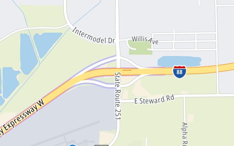
Map & services within two (2) miles
Interactive map shows available cameras, plus nearby fuel, food and lodging


See below for more about this area
Interactive map shows available cameras, plus nearby fuel, food and lodging
See below for more about this area
This is Exit 76 of the Ronald Reagan Memorial Tollway.
This junction is located in Rochelle. Hillcrest is nearby.
This location is in the Chicagoland - Northwestern Indiana area.
This location's approximate GPS Coordinates are 41.90029 x -89.06848.
Which directions can I travel from here?
From this junction, traffic can enter traveling both westbound and eastbound. Traffic can also exit traveling both westbound and eastbound.
On to I–39, about 2.5 miles away ►
◄ Back to IL 26, about 22.2 miles away.
Which direction are tolls charged here?
Tolls are not charged or collected at this junction.
Above: Map image © TomTom Intl BVThe interactive map and lists on this page include key traveler services within two miles of this destination point.
You will find common services, including gas stations, truck stops, EV charging facilities, fast-food or family restaurants, and hotels. These are displayed on the interactive map as markers, which you can select for more information.
Current driving conditions and weather, along with a more complete list of key services, may be found below the map.

Cloudy
46°F / 8°C
Feels Like:
43°F / 6.3°C
Visibility
11 Mi / 17.7 Km
3-Hour Precip:
0 In / 0.0 Cm
East
Winds (E)
9.9 MPH / 15.9 KPH
Gusts:
14.7 MPH / 23.7 KPH
▸ Get the full forecast for This Location | The Chicagoland - Northwestern Indiana area
Conditions and forecasts provided in partnership with AccuWeather.

Weather provided in partnership with AccuWeather.
There is no currently-available traffic camera feed for this location.
There are no currently-available photos for this location.
The map above shows all services within about a two (2) mile radius.

Destination Travel

Closest Gas Stations
KWIK STAR
1000 South 7th Street • 0.68 miles
Store/Fuel Brand: Kwik Star
STOP N GO
1000 South 7th Street • 0.68 miles
Store/Fuel Brand:
LOVE'S TRAVEL STOP
400 East Steward Road • 1,077 feet
Store/Fuel Brand:
SHELL
452 Lake Lida Lane • 1,228 feet
Store/Fuel Brand: Shell
Closest EV Chargers
ROCHELLE, IL SUPERCHARGER
330 South 7th Street • 1.15 miles
CONNECTOR: Tesla
POWER: 250 KW @ 400 V
CURRENT: 625 Amp DC
CHARGEPOINT
426 North Main Street • 1.59 miles
CONNECTOR: IEC62196Type1
POWER: 6 KW @ 240 V
CURRENT: 27 Amp AC1

Closest Fast Food
Fast food refers ONLY to quick-service and take-out diners. All restaurant types are shown on the map above.
HARDEE'S
400 East Steward Road • 942 feet
Journey to key destinations around and adjacent to Illinois!
Communities in this metro area include Chicago, Aurora, Oak Lawn, Des Plaines, Waukegan, Highland Park, Gary, Indiana, Schaumburg, Naperville, Oak Brook, and Joliet.
Individual toll maps for this region are listed below.
Communities in this metro area include Gary, South Bend, Elkhart, Portage, and Fremont.
Individual toll maps for this region are listed below.
 Chicago Skyway ▹
 Jane Addams Memorial Tollway ▹
 Ronald Reagan Memorial Tollway ▹
 Tri State Tollway ▹
 Veterans Memorial Tollway ▹
 Cline Avenue Bridge ▹
 Houbolt Road Extension ▹
 Indiana Toll Road ▹
 Ohio Turnpike ▹


