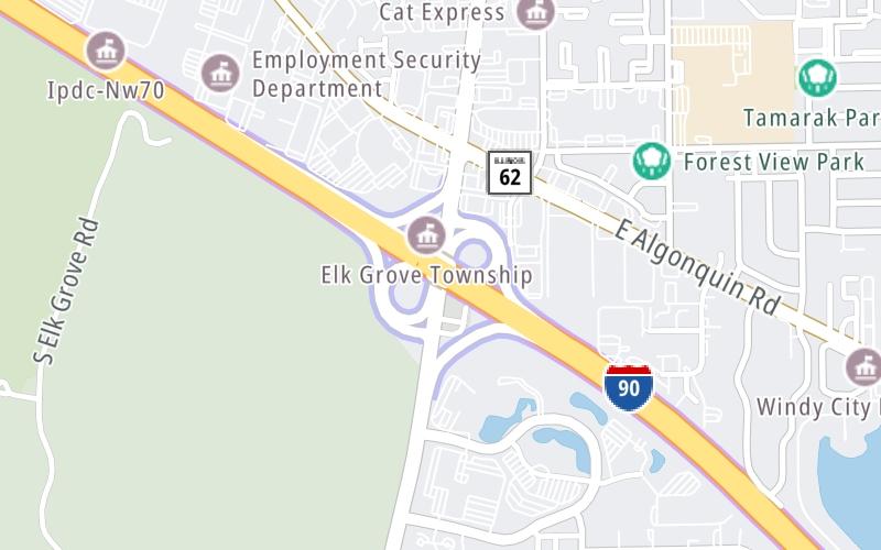
Map & services within two (2) miles
Interactive map shows available cameras, plus nearby fuel, food and lodging


See below for more about this area
Interactive map shows available cameras, plus nearby fuel, food and lodging
See below for more about this area
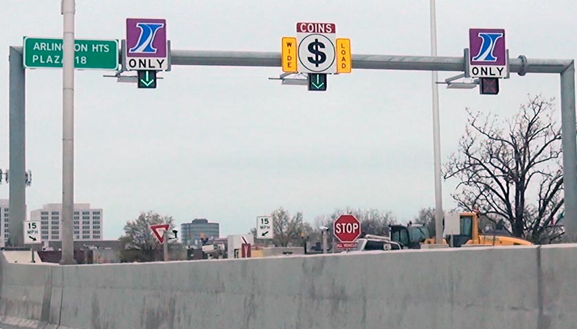
This is Exit 70 of the Jane Addams Memorial Tollway.
This junction is located in Mount Prospect. Arlington Heights is nearby.
This location is in the Chicagoland - Northwestern Indiana area.
This location's approximate GPS Coordinates are 42.04049 x -87.98374.
Which directions can I travel from here?
From this junction, traffic can enter traveling both westbound and eastbound. Traffic can also exit traveling both westbound and eastbound.
On to Elmhurst Road, about 2.8 miles away ►
◄ Back to I–290 / Illinois 53, about 2.6 miles away.
Which direction are tolls charged here?
The interactive map and lists on this page include key traveler services within two miles of this destination point.
You will find common services, including gas stations, truck stops, EV charging facilities, fast-food or family restaurants, and hotels. These are displayed on the interactive map as markers, which you can select for more information.
Current driving conditions and weather, along with a more complete list of key services, may be found below the map.

Mostly Cloudy
35°F / 1.9°C
Feels Like:
37°F / 2.7°C
Visibility
11 Mi / 17.7 Km
3-Hour Precip:
0 In / 0.0 Cm
Northeast
Winds (NE)
2.7 MPH / 4.3 KPH
Gusts:
11.7 MPH / 18.9 KPH
▸ Get the full forecast for This Location | The Chicagoland - Northwestern Indiana area
Conditions and forecasts provided in partnership with AccuWeather.

Weather provided in partnership with AccuWeather.
There is no currently-available traffic camera feed for this location.
About this photo:
Photo taken 04-27-2016
The map above shows all services within about a two (2) mile radius.

Destination Travel

Closest Gas Stations
CHEMMAN MOBIL
1880 South Arlington Heights Road • 0.78 miles
Store/Fuel Brand: Mobil
MOBIL
8 East Higgins Road • 0.84 miles
Store/Fuel Brand: Mobil
MEIJER
1301 Meijer Drive • 0.84 miles
Store/Fuel Brand: Meijer
BP
2250 South Arlington Heights Road • 1,540 feet
Store/Fuel Brand: BP
Closest EV Chargers
50 NWP
50 Northwest Point Boulevard • 0.46 miles
CONNECTOR: IEC62196Type1
POWER: 6 KW @ 208 V
CURRENT: 30 Amp AC1
CHARGEPOINT
Unnamed Road • 0.71 miles
CONNECTOR: IEC62196Type1
POWER: 6 KW @ 240 V
CURRENT: 27 Amp AC1
CHARGEPOINT
2121 South Goebbert Road • 0.71 miles
CONNECTOR: IEC62196Type1
POWER: 6 KW @ 240 V
CURRENT: 27 Amp AC1
CASTLE CHEVROLET NORTH
175 North Arlington Heights Road • 0.73 miles
CONNECTOR: IEC62196Type1CCS
POWER: 60 KW @ 1000 V
CURRENT: 150 Amp DC

Closest Fast Food
Fast food refers ONLY to quick-service and take-out diners. All restaurant types are shown on the map above.
JOHNNIE'S BEEF
1935 South Arlington Heights Road • 0.64 miles
MCDONALDS
45 West Golf Road • 0.68 miles
MCDONALD'S
45 East Golf Road • 0.78 miles
BURGER BARON II
132 East Golf Road • 0.81 miles
JIMMY JOHN'S
1317 Golf Road • 0.91 miles
TERIYAKI MADNESS
1319 Golf Road • 0.92 miles
PANERA BREAD
1321 Golf Road • 0.93 miles
TENSUKE MARKET
• 0.93 miles
Journey to key destinations around and adjacent to Illinois!
Communities in this metro area include Chicago, Aurora, Oak Lawn, Des Plaines, Waukegan, Highland Park, Gary, Indiana, Schaumburg, Naperville, Oak Brook, and Joliet.
Individual toll maps for this region are listed below.
Communities in this metro area include Gary, South Bend, Elkhart, Portage, and Fremont.
Individual toll maps for this region are listed below.
 Chicago Skyway ▹
 Jane Addams Memorial Tollway ▹
 Ronald Reagan Memorial Tollway ▹
 Tri State Tollway ▹
 Veterans Memorial Tollway ▹
 Cline Avenue Bridge ▹
 Houbolt Road Extension ▹
 Indiana Toll Road ▹
 Ohio Turnpike ▹


