Osceola Parkway Map

Advertising
Advertising
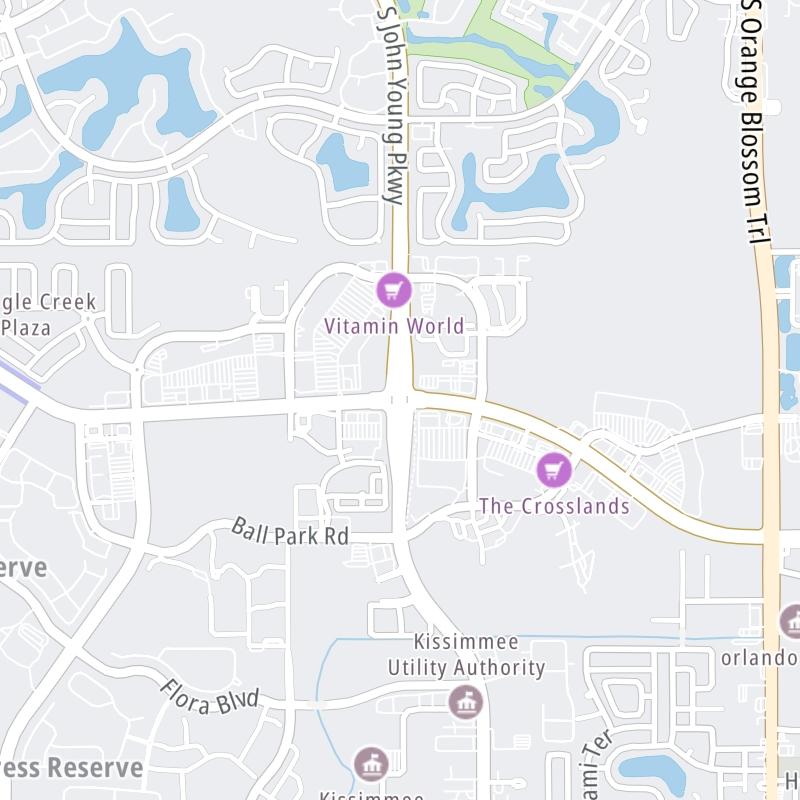
Static map a segment of Osceola Parkway

A Quick Look At Osceola Parkway

This local toll road serves several key cities, including Celebration and Kissimmee.

The fixed map seen here presents a quick view of Osceola Parkway and surrounding area. The fully-interactive map of Osceola Parkway below includes linked markers. You may resize and reposition the interactive map to orient the road in relation to other landmarks.

There is also a complete list of exits below the interactive map.

View Map ▾Exit / POI List ▾

What Does It Cost To Use Osceola Parkway?

Tolls For Cars, SUVs, Pickups, etc.

This data will be here soon.

Transponders You Can Use

For drivers paying with a transponder, the following passes will work on Osceola Parkway

  • epass
  • epass xtra
  • uni
  • sunpass pro
  • sunpass
  • e-zpass
  • i-pass
  • peach pass
  • quick pass

Learn about transponders and accounts in Florida.

View Map ▾All Tolls / Calculator ▸

Our new toll and trip calculator is being constructed. For most roads, you can still use the legacy calculator for current, accurate tolls.

Advertising
Advertising

Using The Interactive Toll Map

You may pan and zoom the interactive map. There are markers you may select for a separate map of that point of interest or location, which will show any nearby dining, gas, EV charging, hotels and other services.

A complete list of exits and other points-of-interest may be found below the map. Exits and gantries will display the toll agency responsible for tolls on that portion of the roadway.

View Map ▾Exit / POI List ▾

Advertising
Advertising

Osceola Parkway Toll Map

This map of Osceola Parkway displays markers for exits and tolling points, which you can select to get a close-up map of that point of interest or location.

The points-of-interest shown on this map are also listed below.

Discover Florida Attractions

Advertising
Advertising

List Of Exits / Points Of Interest For Osceola Parkway

Select an exit or other location to get a separate map, including locations of available gas, EV charging, fast-food and other dining options, plus current weather and driving conditions.

World Dr

World Dr — Bay Lake

View Map & Info

▸ GPS 28.348421000 X -81.565116000
NOTES: Disney World

CFX Central Florida Expressway Authority manages this segment.

S Victory Way

S Victory Way — Bay Lake

View Map & Info

▸ GPS 28.347900000 X -81.552511000
NOTES:

CFX Central Florida Expressway Authority manages this segment.

I-4

I-4 — Bay Lake

View Map & Info

▸ GPS 28.345575000 X -81.533244000
NOTES: Interstate 4 / Exit 65 from I-4 to Osceola

CFX Central Florida Expressway Authority manages this segment.

International Dr

International Dr — Celebration

View Map & Info

▸ GPS 28.344843000 X -81.523036000
NOTES:

CFX Central Florida Expressway Authority manages this segment.

SR 417

SR 417 — Celebration

View Map & Info

▸ GPS 28.341663000 X -81.517249000
NOTES: Central Florida Greeneway

CFX Central Florida Expressway Authority manages this segment.

Seralago Blvd

Seralago Blvd — Kissimmee

View Map & Info

▸ GPS 28.338342000 X -81.506037000
NOTES: Golf course

CFX Central Florida Expressway Authority manages this segment.

N Poinciana Blvd

N Poinciana Blvd — Kissimmee

View Map & Info

▸ GPS 28.340183000 X -81.485182000
NOTES: EB exit here for Apopka Vineland Rd/SR 535

CFX Central Florida Expressway Authority manages this segment.

Apopka Vineland Rd/SR 535

Apopka Vineland Rd/SR 535 — Kissimmee

View Map & Info

▸ GPS 28.340498000 X -81.482067000
NOTES: WB exit here for Poinciana Blvd

CFX Central Florida Expressway Authority manages this segment.

Sunrise City Dr / Storey Lake Blvd

Sunrise City Dr / Storey Lake Blvd — Kissimmee

View Map & Info

▸ GPS 28.344366000 X -81.470587000
NOTES: Turn south for Storey Lake & to U.S. Hwy 192

CFX Central Florida Expressway Authority manages this segment.

Shingle Creek Toll Gantry

Shingle Creek Toll Gantry — Kissimmee

View Map & Info

▸ GPS 28.344623000 X -81.438977000
NOTES: Toll gantry

CFX Central Florida Expressway Authority manages this segment.

Dyer Blvd

Dyer Blvd — Kissimmee

View Map & Info

▸ GPS 28.341884000 X -81.430981000
NOTES:

CFX Central Florida Expressway Authority manages this segment.

John Young Pkwy

John Young Pkwy — Kissimmee

View Map & Info

▸ GPS 28.342401000 X -81.419678000
NOTES:

CFX Central Florida Expressway Authority manages this segment.

Greenwald Way N

Greenwald Way N — Kissimmee

View Map & Info

▸ GPS 28.342131000 X -81.416304000
NOTES:

CFX Central Florida Expressway Authority manages this segment.

Centerview Blvd

Centerview Blvd — Kissimmee

View Map & Info

▸ GPS 28.340574000 X -81.411953000
NOTES:

CFX Central Florida Expressway Authority manages this segment.

U.S. Hwy 441

U.S. Hwy 441 — Kissimmee

View Map & Info

▸ GPS 28.337262000 X -81.403763000
NOTES:

CFX Central Florida Expressway Authority manages this segment.

S Orange Ave

S Orange Ave — Kissimmee

View Map & Info

▸ GPS 28.340260000 X -81.393498000
NOTES: CR 527

CFX Central Florida Expressway Authority manages this segment.

Michigan Ave

Michigan Ave — Kissimmee

View Map & Info

▸ GPS 28.340521000 X -81.387887000
NOTES:

CFX Central Florida Expressway Authority manages this segment.

Bill Beck Blvd

Bill Beck Blvd — Kissimmee

View Map & Info

▸ GPS 28.340509000 X -81.383222000
NOTES:

CFX Central Florida Expressway Authority manages this segment.

Florida's Turnpike

Florida's Turnpike — Kissimmee

View Map & Info

▸ GPS 28.341000000 X -81.380388000
NOTES:

CFX Central Florida Expressway Authority manages this segment.

Florida Pkwy / Coral Reef Cir

Florida Pkwy / Coral Reef Cir — Kissimmee

View Map & Info

▸ GPS 28.344241000 X -81.373115000
NOTES: South for Florida Pkwy

CFX Central Florida Expressway Authority manages this segment.

Buenaventura Blvd

Buenaventura Blvd — Kissimmee

View Map & Info

▸ GPS 28.344813000 X -81.362744000
NOTES:

CFX Central Florida Expressway Authority manages this segment.

SR 530

SR 530 — Kissimmee

View Map & Info

▸ GPS 28.342097000 X -81.326481000
NOTES: Simpson Rd

CFX Central Florida Expressway Authority manages this segment.

Advertising
Advertising

EXPLORE FLORIDA

Journey to key destinations around and adjacent to Florida!

Map Of This Region ▹

Communities in this metro area include Destin, Pensacola Beach, Pensacola, Niceville, and Gulf Breeze.

Individual toll maps for this region are listed below.

Map Of This Region ▹

Communities in this metro area include Jacksonville and Middleburg.

Individual toll maps for this region are listed below.

Map Of This Region ▹

Communities in this metro area include Apopka, Cocoa, Kissimmee, Lake Buena Vista, Orlando, Saint Cloud, Sanford, Titusville, Melbourne, Poinciana, and Mount Dora.

Individual toll maps for this region are listed below.

Map Of This Region ▹

Communities in this metro area include Bradenton, Brandon, Saint Petersburg, Spring Hill, and Tampa.

Individual toll maps for this region are listed below.

Map Of This Region ▹

Communities in this metro area include Fort Pierce, Port Saint Lucie, Stuart, and Vero Beach.

Individual toll maps for this region are listed below.

Map Of This Region ▹

Communities in this metro area include Fort Lauderdale, Pompano Beach, Hialeah, Opa Locka, Homestead, Kendall, Key Largo, Miramar, Miami, Hollywood, Sunrise, Boca Raton, Delray Beach, West Palm Beach, Jupiter, Davie, Coral Springs, Lake Worth, and Boynton Beach.

Individual toll maps for this region are listed below.

Map Of This Region ▹

Communities in this metro area include Fort Myers, Naples, and Cape Coral.

Individual toll maps for this region are listed below.

Map Of This Region ▹

Communities in this metro area include Mobile, Daphne, Dauphin Island, Chickasaw, and Spanish Fort.

Individual toll maps for this region are listed below.

beaches-gulf coast

Roads Within Region

Map Of This Region ▹

Advertising
Advertising
Turnpikes.com is proud to partner with the following: