Map & services within two (2) miles
Interactive map shows available cameras, plus nearby fuel, food and lodging


See below for more about this area
Interactive map shows available cameras, plus nearby fuel, food and lodging
See below for more about this area
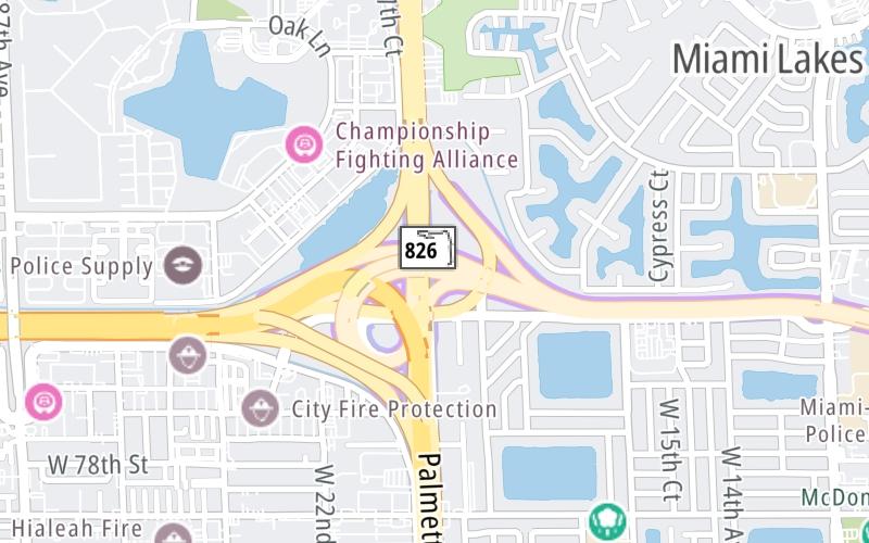
This is Exit 1A/1B of the Gratigny Parkway.
This junction is located in Hialeah. Miami Lakes is nearby.
This location is in the Miami - South Florida area.
This location's approximate GPS Coordinates are 25.90018 x -80.32374.
Which directions can I travel from here?
From this junction, traffic can enter traveling both westbound and eastbound. Traffic can also exit traveling both westbound and eastbound.
On to NW 57th Avenue/Red Road, about 2.0 miles away ►
Which direction are tolls charged here?
Tolls are not charged or collected at this junction.
Above: Map image © TomTom Intl BVThe interactive map and lists on this page include key traveler services within two miles of this destination point.
You will find common services, including gas stations, truck stops, EV charging facilities, fast-food or family restaurants, and hotels. These are displayed on the interactive map as markers, which you can select for more information.
Current driving conditions and weather, along with a more complete list of key services, may be found below the map.

Mostly Clear
75°F / 23.9°C
Feels Like:
83°F / 28.2°C
Visibility
9 Mi / 14.5 Km
3-Hour Precip:
0 In / 0.0 Cm
West
Winds (W)
1 MPH / 1.7 KPH
Gusts:
5.1 MPH / 8.3 KPH
▸ Get the full forecast for This Location | The Miami - South Florida area
Conditions and forecasts provided in partnership with AccuWeather.

Weather provided in partnership with AccuWeather.

(101) SR-924 EAST OF SR-826
Camera Direction: EAST. Source: FDOT - undetermined 33014
Cameras Closest To SR 826/Palmetto Expy / I–75
84 Ft
668 Ft
0.53 Mi
0.81 Mi
1.00 Mi
There are no currently-available photos for this location.
The map above shows all services within about a two (2) mile radius.

Destination Travel

Closest Gas Stations
SUNSHINE
2290 West 84th Street • 0.44 miles
Store/Fuel Brand: Exxon
SUNOCO
1540 West 84th Street • 0.55 miles
Store/Fuel Brand: Sunoco
ORION
2390 West 76th Street • 0.79 miles
Store/Fuel Brand:
CHEVRON
7375 Miami Lakes Drive • 0.82 miles
Store/Fuel Brand: Chevron
Closest EV Chargers
CHARGEPOINT
15200 Northwest 77th Court • 0.79 miles
CONNECTOR: IEC62196Type1
POWER: 9 KW @ 240 V
CURRENT: 40 Amp AC1
CHARGEPOINT
8332 Commerce Way • 0.80 miles
CONNECTOR: IEC62196Type1
POWER: 6 KW @ 240 V
CURRENT: 27 Amp AC1
MIAMI-DADE FIRE DEPARTMENT STATION 64
15325 Northwest 77th Court • 0.86 miles
CONNECTOR: IEC62196Type1
POWER: 19 KW @ 240 V
CURRENT: 80 Amp AC1
MIAMI LAKES OFFICE PARK
14400 Northwest 77th Court • 1,835 feet
CONNECTOR: IEC62196Type1
POWER: 6 KW @ 208 V
CURRENT: 30 Amp AC1

Closest Fast Food
Fast food refers ONLY to quick-service and take-out diners. All restaurant types are shown on the map above.
MCDONALD'S
7435 Miami Lakes Drive • 0.78 miles
BURGERFI
7431 Miami Lakes Drive • 0.80 miles
HOLIDAY BAKERY
• 0.82 miles
BURGER KING
15320 Northwest 79th Court • 0.91 miles
PAL-MEDICAL PIZZA PASTA & GRILL
7160 W 20Th Ave • 0.93 miles
SMOOTHIE KING
15366 Northwest 79th Court • 0.97 miles
EINSTEIN BROTHERS BAGELS
7970 Northwest 154th Street • 0.98 miles
CHIPOTLE
8000 Northwest 154th Street • 0.99 miles
Journey to key destinations around and adjacent to Florida!
Communities in this metro area include Destin, Pensacola Beach, Pensacola, Niceville, and Gulf Breeze.
Individual toll maps for this region are listed below.

Communities in this metro area include Jacksonville and Middleburg.
Individual toll maps for this region are listed below.

Communities in this metro area include Apopka, Cocoa, Kissimmee, Lake Buena Vista, Orlando, Saint Cloud, Sanford, Titusville, Melbourne, Poinciana, and Mount Dora.
Individual toll maps for this region are listed below.
Communities in this metro area include Bradenton, Brandon, Saint Petersburg, Spring Hill, and Tampa.
Individual toll maps for this region are listed below.
Communities in this metro area include Fort Pierce, Port Saint Lucie, Stuart, and Vero Beach.
Individual toll maps for this region are listed below.

Communities in this metro area include Fort Lauderdale, Pompano Beach, Hialeah, Opa Locka, Homestead, Kendall, Key Largo, Miramar, Miami, Hollywood, Sunrise, Boca Raton, Delray Beach, West Palm Beach, Jupiter, Davie, Coral Springs, Lake Worth, and Boynton Beach.
Individual toll maps for this region are listed below.
Communities in this metro area include Fort Myers, Naples, and Cape Coral.
Individual toll maps for this region are listed below.
Communities in this metro area include Mobile, Daphne, Dauphin Island, Chickasaw, and Spanish Fort.
Individual toll maps for this region are listed below.

Roads Within Region
 Garcon Point Bridge ▹
 Bob Sikes Bridge ▹
 SR 293 ▹
 First Coast Expressway ▹
 Central Florida Greeneway/Seminole Expy ▹
 Florida's Turnpike ▹
 East West Expressway ▹
 Beachline Expressway ▹
 Western Beltway/Wekiva Pkwy ▹
 Apopka Expressway ▹
 Poinciana Parkway ▹
 SR 453 ▹
 Goldenrod Road Extension ▹
 Osceola Parkway ▹
 SR 451 ▹
 Polk Parkway ▹
 Selmon Expressway ▹
 Suncoast Parkway/Veterans Expy ▹
 Sunshine Skyway ▹
 Pinellas Bayway ▹
 Gateway Expressway ▹
 Airport Expressway ▹
 Alligator Alley ▹
 Dolphin Expressway ▹
 Don Shula Expressway ▹
 Gratigny Parkway ▹
 Sawgrass Expressway ▹
 Snapper Creek Expressway ▹
 Rickenbacker Causeway ▹
 Venetian Causeway ▹
 Card Sound Road ▹
 Sanibel Causeway ▹
 Midpoint Memorial Bridge ▹
 Cape Coral Bridge ▹


