Map & services within two (2) miles
Interactive map shows available cameras, plus nearby fuel, food and lodging


See below for more about this area
Interactive map shows available cameras, plus nearby fuel, food and lodging
See below for more about this area
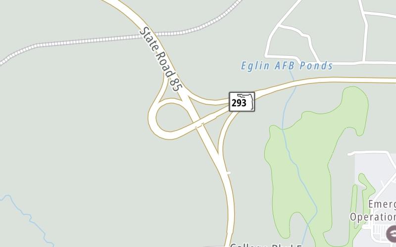
This junction is located in Niceville. Valparaiso is nearby. NOTE: North terminus of SR 293 / Spence Parkway / Mid-Bay Bridge Connector.
This location is in the Pensacola - Florida Panhandle area.
This location's approximate GPS Coordinates are 30.54433 x -86.49502.
Which directions can I travel from here?
From this junction, traffic can only enter going southbound. Traffic can only exit going northbound.
◄ Back to SR 285, about 2.6 miles away.
Which direction are tolls charged here?
Tolls are not charged or collected at this junction.
Above: Map image © TomTom Intl BVThe interactive map and lists on this page include key traveler services within two miles of this destination point.
You will find common services, including gas stations, truck stops, EV charging facilities, fast-food or family restaurants, and hotels. These are displayed on the interactive map as markers, which you can select for more information.
Current driving conditions and weather, along with a more complete list of key services, may be found below the map.

Mostly Cloudy
78°F / 25.6°C
Feels Like:
90°F / 32.2°C
Visibility
10 Mi / 16.1 Km
3-Hour Precip:
0 In / 0.0 Cm
North
Winds (N)
0 MPH / 0 KPH
Gusts:
4.3 MPH / 7 KPH
▸ Get the full forecast for This Location | The Pensacola - Florida Panhandle area
Conditions and forecasts provided in partnership with AccuWeather.

Weather provided in partnership with AccuWeather.
There is no currently-available traffic camera feed for this location.
There are no currently-available photos for this location.
The map above shows all services within about a two (2) mile radius.

Destination Travel

Closest Gas Stations
TOM THUMB
598 College Boulevard West • 0.67 miles
Store/Fuel Brand: Tom Thumb
CEFCO
555 Highway 85 North • 0.72 miles
Store/Fuel Brand: CEFCO
EXXON
187 John Sims Parkway East • 1.64 miles
Store/Fuel Brand: Exxon
Closest EV Chargers
TOWNEPLACE SUITES MARRIOTT HOTEL NICEVILLE
100 Niceville Avenue • 1.42 miles
CONNECTOR: IEC62196Type1
POWER: 6 KW @ 200 V
CURRENT: 30 Amp AC1
TOWNEPLACE SUITES MARRIOTT HOTEL NICEVILLE
100 Niceville Avenue • 1.42 miles
CONNECTOR: Tesla
POWER: 6 KW @ 200 V
CURRENT: 30 Amp AC1
HOLIDAY INN EXPRESS & SUITES - NICEVILLE
410 John Sims Parkway West • 1.54 miles
CONNECTOR: IEC62196Type1
POWER: 7 KW @ 240 V
CURRENT: 30 Amp AC1
BEST WESTERN - NICEVILLE
106 Bayshore Drive • 1.65 miles
CONNECTOR: IEC62196Type1
POWER: 7 KW @ 240 V
CURRENT: 30 Amp AC1

Closest Fast Food
Fast food refers ONLY to quick-service and take-out diners. All restaurant types are shown on the map above.
TACO BELL
110 John Sims Parkway West • 1.48 miles
FRESH GREECE
111 John Sims Parkway West • 1.50 miles
CEFCO
College Boulevard East • 1.59 miles
MRBEAST BURGER
191 John Sims Parkway East • 1.66 miles
DQ GRILL & CHILL
406 John Sims Parkway East • 1.68 miles
DANNY'S FRIED CHICKEN
408 John Sims Parkway East • 1.69 miles
BURGER KING
297 John Sims Parkway East • 1.70 miles
PAPA JOHN'S
410 John Sims Parkway East • 1.70 miles
Journey to key destinations around and adjacent to Florida!
Communities in this metro area include Destin, Pensacola Beach, Pensacola, Niceville, and Gulf Breeze.
Individual toll maps for this region are listed below.

Communities in this metro area include Jacksonville and Middleburg.
Individual toll maps for this region are listed below.

Communities in this metro area include Apopka, Cocoa, Kissimmee, Lake Buena Vista, Orlando, Saint Cloud, Sanford, Titusville, Melbourne, Poinciana, and Mount Dora.
Individual toll maps for this region are listed below.
Communities in this metro area include Bradenton, Brandon, Saint Petersburg, Spring Hill, and Tampa.
Individual toll maps for this region are listed below.
Communities in this metro area include Fort Pierce, Port Saint Lucie, Stuart, and Vero Beach.
Individual toll maps for this region are listed below.

Communities in this metro area include Fort Lauderdale, Pompano Beach, Hialeah, Opa Locka, Homestead, Kendall, Key Largo, Miramar, Miami, Hollywood, Sunrise, Boca Raton, Delray Beach, West Palm Beach, Jupiter, Davie, Coral Springs, Lake Worth, and Boynton Beach.
Individual toll maps for this region are listed below.
Communities in this metro area include Fort Myers, Naples, and Cape Coral.
Individual toll maps for this region are listed below.
Communities in this metro area include Mobile, Daphne, Dauphin Island, Chickasaw, and Spanish Fort.
Individual toll maps for this region are listed below.

Roads Within Region
 Garcon Point Bridge ▹
 Bob Sikes Bridge ▹
 SR 293 ▹
 First Coast Expressway ▹
 Central Florida Greeneway/Seminole Expy ▹
 Florida's Turnpike ▹
 East West Expressway ▹
 Beachline Expressway ▹
 Western Beltway/Wekiva Pkwy ▹
 Apopka Expressway ▹
 Poinciana Parkway ▹
 SR 453 ▹
 Goldenrod Road Extension ▹
 Osceola Parkway ▹
 SR 451 ▹
 Polk Parkway ▹
 Selmon Expressway ▹
 Suncoast Parkway/Veterans Expy ▹
 Sunshine Skyway ▹
 Pinellas Bayway ▹
 Gateway Expressway ▹
 Airport Expressway ▹
 Alligator Alley ▹
 Dolphin Expressway ▹
 Don Shula Expressway ▹
 Gratigny Parkway ▹
 Sawgrass Expressway ▹
 Snapper Creek Expressway ▹
 Rickenbacker Causeway ▹
 Venetian Causeway ▹
 Card Sound Road ▹
 Sanibel Causeway ▹
 Midpoint Memorial Bridge ▹
 Cape Coral Bridge ▹


