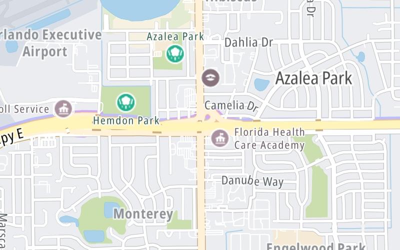
Map & services within two (2) miles
Interactive map shows available cameras, plus nearby fuel, food and lodging


See below for more about this area
Interactive map shows available cameras, plus nearby fuel, food and lodging
See below for more about this area
This is Exit 14 of the East West Expressway.
This junction is located in Orlando. NOTE: WB Off/EB On.
This location is in the Orlando - Space Coast area.
This location's approximate GPS Coordinates are 28.53959 x -81.31058.
Which directions can I travel from here?
From this junction, traffic can only enter going eastbound. Traffic can only exit going westbound.
On to Goldenrod Road, about 1.0 mile away ►
◄ Back to Semoran Blvd / Andes Ave, about 0.6 miles away.
Which direction are tolls charged here?
The interactive map and lists on this page include key traveler services within two miles of this destination point.
You will find common services, including gas stations, truck stops, EV charging facilities, fast-food or family restaurants, and hotels. These are displayed on the interactive map as markers, which you can select for more information.
Current driving conditions and weather, along with a more complete list of key services, may be found below the map.

Mostly Clear
74°F / 23.4°C
Feels Like:
73°F / 22.7°C
Visibility
10 Mi / 16.1 Km
3-Hour Precip:
0 In / 0.0 Cm
East
Winds (E)
4.9 MPH / 7.8 KPH
Gusts:
9.2 MPH / 14.8 KPH
▸ Get the full forecast for This Location | The Orlando - Space Coast area
Conditions and forecasts provided in partnership with AccuWeather.

Weather provided in partnership with AccuWeather.

[NOT PROVIDED]
Camera Direction: EAST. Source: FDOT - undetermined 32807
Cameras Closest To Semoran Blvd / Yucatan Drive
0.32 Mi
0.32 Mi
0.34 Mi
0.68 Mi
1.81 Mi
There are no currently-available photos for this location.
The map above shows all services within about a two (2) mile radius.

Destination Travel

Closest Gas Stations
SEMORAN FOOD MART
1 North Semoran Boulevard • 0.45 miles
Store/Fuel Brand: Marathon
CIRCLE K
801 South Semoran Boulevard • 0.47 miles
Store/Fuel Brand: Circle K
LA ORIENTAL INVESTMENTS
537 North Semoran Boulevard • 0.73 miles
Store/Fuel Brand: Citgo
CITGO
5698 Lake Underhill Rd • 0.73 miles
Store/Fuel Brand: Citgo
Closest EV Chargers
PARK OF THE AMERICAS
201 Andes Avenue • 0.40 miles
CONNECTOR: IEC62196Type1
POWER: 7 KW @ 240 V
CURRENT: 30 Amp AC1
EOC ORLANDO OPS CENTER
224 George DeSalvia Way • 0.57 miles
CONNECTOR: IEC62196Type1
POWER: 7 KW @ 240 V
CURRENT: 30 Amp AC1
CODE ENFORCEMENT
110 George Desalvia Way • 0.69 miles
CONNECTOR: IEC62196Type1
POWER: 7 KW @ 240 V
CURRENT: 30 Amp AC1
CHARGEPOINT
4974 ORL Tower Road • 0.74 miles
CONNECTOR: IEC62196Type1
POWER: 6 KW @ 240 V
CURRENT: 27 Amp AC1

Closest Fast Food
Fast food refers ONLY to quick-service and take-out diners. All restaurant types are shown on the map above.
DUNKIN'
1131 South Semoran Boulevard • 0.75 miles
ROBERTO CLEMENTE MIDDLE SCHOOL
6000 Roberto Clemente Road • 0.79 miles
MCDONALD'S
1505 South Semoran Boulevard • 1.03 miles
HOT DOG HEAVEN
5355 East Colonial Drive • 1.13 miles
POLLO TROPICAL
1811 South Semoran Boulevard • 1.28 miles
TROPICAL SMOOTHIE CAFE
4960 East Colonial Drive • 1.29 miles
TACO BELL
2050 South Semoran Boulevard • 1.35 miles
BRAVO SUPERMARKET
999 North Semoran Boulevard • 1.44 miles
Journey to key destinations around and adjacent to Florida!
Communities in this metro area include Destin, Pensacola Beach, Pensacola, Niceville, and Gulf Breeze.
Individual toll maps for this region are listed below.

Communities in this metro area include Jacksonville and Middleburg.
Individual toll maps for this region are listed below.

Communities in this metro area include Apopka, Cocoa, Kissimmee, Lake Buena Vista, Orlando, Saint Cloud, Sanford, Titusville, Melbourne, Poinciana, and Mount Dora.
Individual toll maps for this region are listed below.
Communities in this metro area include Bradenton, Brandon, Saint Petersburg, Spring Hill, and Tampa.
Individual toll maps for this region are listed below.
Communities in this metro area include Fort Pierce, Port Saint Lucie, Stuart, and Vero Beach.
Individual toll maps for this region are listed below.

Communities in this metro area include Fort Lauderdale, Pompano Beach, Hialeah, Opa Locka, Homestead, Kendall, Key Largo, Miramar, Miami, Hollywood, Sunrise, Boca Raton, Delray Beach, West Palm Beach, Jupiter, Davie, Coral Springs, Lake Worth, and Boynton Beach.
Individual toll maps for this region are listed below.
Communities in this metro area include Fort Myers, Naples, and Cape Coral.
Individual toll maps for this region are listed below.
Communities in this metro area include Tallahassee, Quincy, Midway, and Fort Braden.
Individual toll maps for this region are listed below.

Roads Within Region
Communities in this metro area include Mobile, Daphne, Dauphin Island, Chickasaw, and Spanish Fort.
Individual toll maps for this region are listed below.

Roads Within Region
 Garcon Point Bridge ▹
 Bob Sikes Bridge ▹
 SR 293 ▹
 First Coast Expressway ▹
 Central Florida Greeneway/Seminole Expy ▹
 Florida's Turnpike ▹
 East West Expressway ▹
 Beachline Expressway ▹
 Western Beltway/Wekiva Pkwy ▹
 Apopka Expressway ▹
 Poinciana Parkway ▹
 SR 453 ▹
 Goldenrod Road Extension ▹
 Osceola Parkway ▹
 SR 451 ▹
 Polk Parkway ▹
 Selmon Expressway ▹
 Suncoast Parkway/Veterans Expy ▹
 Sunshine Skyway ▹
 Pinellas Bayway ▹
 Gateway Expressway ▹
 Airport Expressway ▹
 Alligator Alley ▹
 Dolphin Expressway ▹
 Don Shula Expressway ▹
 Gratigny Parkway ▹
 Sawgrass Expressway ▹
 Snapper Creek Expressway ▹
 Rickenbacker Causeway ▹
 Venetian Causeway ▹
 Card Sound Road ▹
 Sanibel Causeway ▹
 Midpoint Memorial Bridge ▹
 Cape Coral Bridge ▹


