Map & services within two (2) miles
Interactive map shows available cameras, plus nearby fuel, food and lodging


See below for more about this area
Interactive map shows available cameras, plus nearby fuel, food and lodging
See below for more about this area
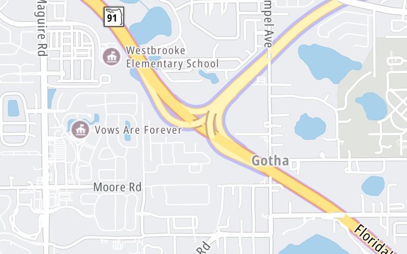
This junction is located in Orlando. NOTE: WB Off/EB On.
This location is in the Orlando - Space Coast area.
This location's approximate GPS Coordinates are 28.53425 x -81.52844.
Which directions can I travel from here?
From this junction, traffic can only enter going eastbound. Traffic can only exit going westbound.
On to SR 50 / Clarke Road, about 0.8 miles away ►
▹ The East West Expressway and the Floridas Turnpike connect here.
Which direction are tolls charged here?
Tolls are not charged or collected at this junction.
Above: Map image © TomTom Intl BVThe interactive map and lists on this page include key traveler services within two miles of this destination point.
You will find common services, including gas stations, truck stops, EV charging facilities, fast-food or family restaurants, and hotels. These are displayed on the interactive map as markers, which you can select for more information.
Current driving conditions and weather, along with a more complete list of key services, may be found below the map.

Mostly Clear
72°F / 22.4°C
Feels Like:
74°F / 23.2°C
Visibility
11 Mi / 17.7 Km
3-Hour Precip:
0 In / 0.0 Cm
East
Winds (E)
3.2 MPH / 5.2 KPH
Gusts:
9.2 MPH / 14.8 KPH
▸ Get the full forecast for This Location | The Orlando - Space Coast area
Conditions and forecasts provided in partnership with AccuWeather.

Weather provided in partnership with AccuWeather.

TPKE MM 266.1 AT SR-408
Camera Direction: SOUTH. Source: FDOT - undetermined 34734
Cameras Closest To Florida's Turnpike
370 Ft
0.55 Mi
0.79 Mi
0.82 Mi
1.09 Mi
There are no currently-available photos for this location.
The map above shows all services within about a two (2) mile radius.

Destination Travel

Closest Gas Stations
CAR WASH
2594 Maguire Road • 0.71 miles
Store/Fuel Brand:
SPEEDWAY
2710 Maguire Road • 0.83 miles
Store/Fuel Brand: Speedway
7-ELEVEN #38204
3844 Old Winter Garden Road • 0.92 miles
Store/Fuel Brand: 7-Eleven
RACETRAC
10751 West Colonial Drive • 1.34 miles
Store/Fuel Brand: Racetrac
Closest EV Chargers
PARK PLACE AT MAGUIRE
100 Maguire Park Street • 0.96 miles
CONNECTOR: IEC62196Type1
POWER: 6 KW @ 270 V
CURRENT: 24 Amp AC1
MOB LOT
10000 West Colonial Drive • 1.07 miles
CONNECTOR: IEC62196Type1
POWER: 7 KW @ 240 V
CURRENT: 30 Amp AC1
2801 OLD WINTER GARDEN ROAD
2801 Old Winter Garden Road • 1.23 miles
CONNECTOR: IEC62196Type1
POWER: 7 KW @ 240 V
CURRENT: 30 Amp AC1
PHYSICIANS LOT
10001 West Colonial Drive • 1.30 miles
CONNECTOR: IEC62196Type1
POWER: 7 KW @ 240 V
CURRENT: 30 Amp AC1

Closest Fast Food
Fast food refers ONLY to quick-service and take-out diners. All restaurant types are shown on the map above.
MARCO'S PIZZA
2524 Maguire Road • 0.74 miles
MARCO'S PIZZA
2560 Maguire Park St • 1.03 miles
CHECKERS
10500 West Colonial Drive • 1.08 miles
KRISPY KRUNCHY CHICKEN
10500 West Colonial Drive • 1.09 miles
AUNTIE ANNE'S
10500 West Colonial Drive • 1.09 miles
JERSEY MIKE'S SUBS
10588 West Colonial Drive • 1.18 miles
CHICK-FIL-A
10620 West Colonial Drive • 1.20 miles
WENDY'S
10674 West Colonial Drive • 1.21 miles
Journey to key destinations around and adjacent to Florida!
Communities in this metro area include Destin, Pensacola Beach, Pensacola, Niceville, and Gulf Breeze.
Individual toll maps for this region are listed below.

Communities in this metro area include Jacksonville and Middleburg.
Individual toll maps for this region are listed below.

Communities in this metro area include Apopka, Cocoa, Kissimmee, Lake Buena Vista, Orlando, Saint Cloud, Sanford, Titusville, Melbourne, Poinciana, and Mount Dora.
Individual toll maps for this region are listed below.
Communities in this metro area include Bradenton, Brandon, Saint Petersburg, Spring Hill, and Tampa.
Individual toll maps for this region are listed below.
Communities in this metro area include Fort Pierce, Port Saint Lucie, Stuart, and Vero Beach.
Individual toll maps for this region are listed below.

Communities in this metro area include Fort Lauderdale, Pompano Beach, Hialeah, Opa Locka, Homestead, Kendall, Key Largo, Miramar, Miami, Hollywood, Sunrise, Boca Raton, Delray Beach, West Palm Beach, Jupiter, Davie, Coral Springs, Lake Worth, and Boynton Beach.
Individual toll maps for this region are listed below.
Communities in this metro area include Fort Myers, Naples, and Cape Coral.
Individual toll maps for this region are listed below.
Communities in this metro area include Tallahassee, Quincy, Midway, and Fort Braden.
Individual toll maps for this region are listed below.

Roads Within Region
Communities in this metro area include Mobile, Daphne, Dauphin Island, Chickasaw, and Spanish Fort.
Individual toll maps for this region are listed below.

Roads Within Region
 Garcon Point Bridge ▹
 Bob Sikes Bridge ▹
 SR 293 ▹
 First Coast Expressway ▹
 Central Florida Greeneway/Seminole Expy ▹
 Florida's Turnpike ▹
 East West Expressway ▹
 Beachline Expressway ▹
 Western Beltway/Wekiva Pkwy ▹
 Apopka Expressway ▹
 Poinciana Parkway ▹
 SR 453 ▹
 Goldenrod Road Extension ▹
 Osceola Parkway ▹
 SR 451 ▹
 Polk Parkway ▹
 Selmon Expressway ▹
 Suncoast Parkway/Veterans Expy ▹
 Sunshine Skyway ▹
 Pinellas Bayway ▹
 Gateway Expressway ▹
 Airport Expressway ▹
 Alligator Alley ▹
 Dolphin Expressway ▹
 Don Shula Expressway ▹
 Gratigny Parkway ▹
 Sawgrass Expressway ▹
 Snapper Creek Expressway ▹
 Rickenbacker Causeway ▹
 Venetian Causeway ▹
 Card Sound Road ▹
 Sanibel Causeway ▹
 Midpoint Memorial Bridge ▹
 Cape Coral Bridge ▹


