Map & services within two (2) miles
Interactive map shows available cameras, plus nearby fuel, food and lodging


See below for more about this area
Interactive map shows available cameras, plus nearby fuel, food and lodging
See below for more about this area

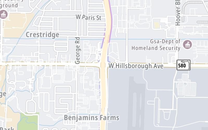
This is Exit 4 of the Suncoast Parkway/Veterans Expy.
This junction is located in Tampa.
This location is in the Tampa Bay - West Central Florida area.
This location's approximate GPS Coordinates are 27.99633 x -82.54582.
Which directions can I travel from here?
From this junction, traffic can enter traveling both southbound and northbound. Traffic can also exit traveling both southbound and northbound.
On to Waters Avenue, about 1.6 miles away ►
◄ Back to Memorial Highway / Eisenhower Boulevard, about 0.6 miles away.
Which direction are tolls charged here?
The interactive map and lists on this page include key traveler services within two miles of this destination point.
You will find common services, including gas stations, truck stops, EV charging facilities, fast-food or family restaurants, and hotels. These are displayed on the interactive map as markers, which you can select for more information.
Current driving conditions and weather, along with a more complete list of key services, may be found below the map.

Sunny
85°F / 29.4°C
Feels Like:
90°F / 32.2°C
Visibility
10 Mi / 16.1 Km
3-Hour Precip:
0 In / 0.0 Cm
Southwest
Winds (SW)
8.1 MPH / 13 KPH
Gusts:
8.1 MPH / 13 KPH
▸ Get the full forecast for This Location | The Tampa Bay - West Central Florida area
Conditions and forecasts provided in partnership with AccuWeather.

Weather provided in partnership with AccuWeather.
There is no currently-available traffic camera feed for this location.
About this photo:
The northbound onramp from Exit 3 becomes the forced exit lane for Exit 4, to Hillsborough Avenue, which runs along the north side of Tampa�s airport. Photo taken September 3, 2022.
Photo taken 09-03-2022
More Pictures Near Hillsborough Avenue


The map above shows all services within about a two (2) mile radius.

Destination Travel

Closest Gas Stations
SHELL
6901 West Hillsborough Avenue • 0.69 miles
Store/Fuel Brand: Shell
THORNTONS
6405 West Hillsborough Avenue • 1,669 feet
Store/Fuel Brand: Thorntons
WAWA
7540 West Hillsborough Avenue • 1.14 miles
Store/Fuel Brand: Wawa
TAMBAY TIRE PLAZA
7659 West Hillsborough Avenue • 1.23 miles
Store/Fuel Brand:
Closest EV Chargers
TAMPA INTERNATIONAL AIRPORT - SHORT TERM PARKING LOT
4205 Bessie Coleman Boulevard • 1.10 miles
CONNECTOR: IEC62196Type1
POWER: 7 KW @ 240 V
CURRENT: 30 Amp AC1
TAMPA AIRPORT MARRIOTT - TESLA DESTINATION
4200 George J Bean Parkway • 1.24 miles
CONNECTOR: Tesla
POWER: 7 KW @ 240 V
CURRENT: 30 Amp AC1

Closest Fast Food
Fast food refers ONLY to quick-service and take-out diners. All restaurant types are shown on the map above.
CACCIATORE BROTHERS
5610 Hanley Road • 1.10 miles
PDQ TEST KITCHEN
4343 Anchor Plaza Parkway • 1.12 miles
WENDY'S
7534 West Hillsborough Avenue • 1.12 miles
WAWA
7540 West Hillsborough Avenue • 1.14 miles
CHECKERS
7545 West Hillsborough Avenue • 1.14 miles
KFC
7605 West Hillsborough Avenue • 1.18 miles
POTBELLY
4200 George J Bean Parkway • 1.21 miles
BURGER 21
4160 George J Bean Parkway • 1.23 miles
Journey to key destinations around and adjacent to Florida!
Communities in this metro area include Destin, Pensacola Beach, Pensacola, Niceville, and Gulf Breeze.
Individual toll maps for this region are listed below.

Communities in this metro area include Jacksonville and Middleburg.
Individual toll maps for this region are listed below.

Communities in this metro area include Apopka, Cocoa, Kissimmee, Lake Buena Vista, Orlando, Saint Cloud, Sanford, Titusville, Melbourne, Poinciana, and Mount Dora.
Individual toll maps for this region are listed below.
Communities in this metro area include Bradenton, Brandon, Saint Petersburg, Spring Hill, and Tampa.
Individual toll maps for this region are listed below.
Communities in this metro area include Fort Pierce, Port Saint Lucie, Stuart, and Vero Beach.
Individual toll maps for this region are listed below.

Communities in this metro area include Fort Lauderdale, Pompano Beach, Hialeah, Opa Locka, Homestead, Kendall, Key Largo, Miramar, Miami, Hollywood, Sunrise, Boca Raton, Delray Beach, West Palm Beach, Jupiter, Davie, Coral Springs, Lake Worth, and Boynton Beach.
Individual toll maps for this region are listed below.
Communities in this metro area include Fort Myers, Naples, and Cape Coral.
Individual toll maps for this region are listed below.
Communities in this metro area include Mobile, Daphne, Dauphin Island, Chickasaw, and Spanish Fort.
Individual toll maps for this region are listed below.

Roads Within Region
 Garcon Point Bridge ▹
 Bob Sikes Bridge ▹
 SR 293 ▹
 First Coast Expressway ▹
 Central Florida Greeneway/Seminole Expy ▹
 Florida's Turnpike ▹
 East West Expressway ▹
 Beachline Expressway ▹
 Western Beltway/Wekiva Pkwy ▹
 Apopka Expressway ▹
 Poinciana Parkway ▹
 SR 453 ▹
 Goldenrod Road Extension ▹
 Osceola Parkway ▹
 SR 451 ▹
 Polk Parkway ▹
 Selmon Expressway ▹
 Suncoast Parkway/Veterans Expy ▹
 Sunshine Skyway ▹
 Pinellas Bayway ▹
 Gateway Expressway ▹
 Airport Expressway ▹
 Alligator Alley ▹
 Dolphin Expressway ▹
 Don Shula Expressway ▹
 Gratigny Parkway ▹
 Sawgrass Expressway ▹
 Snapper Creek Expressway ▹
 Rickenbacker Causeway ▹
 Venetian Causeway ▹
 Card Sound Road ▹
 Sanibel Causeway ▹
 Midpoint Memorial Bridge ▹
 Cape Coral Bridge ▹


