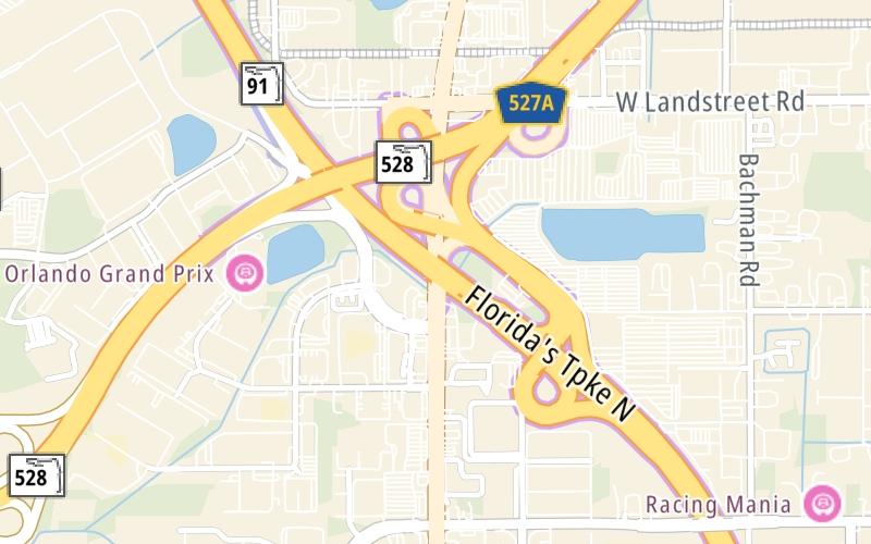
Map & services within two (2) miles
Interactive map shows available cameras, plus nearby fuel, food and lodging


See below for more about this area
Interactive map shows available cameras, plus nearby fuel, food and lodging
See below for more about this area
This is Exit 254 of Florida's Turnpike.
This junction is located in Orlando.
This location is in the Orlando - Space Coast area.
This location's approximate GPS Coordinates are 28.43010 x -81.40470.
Which directions can I travel from here?
From this junction, traffic can enter traveling both southbound and northbound. Traffic can also exit traveling both southbound and northbound.
On to Consulate Drive, about 0.7 miles away ►
◄ Back to SR 417/Central Florida GreeneWay, about 4.6 miles away.
▹ Florida's Turnpike and Beachline Expressway connect here.
Which direction are tolls charged here?
The interactive map and lists on this page include key traveler services within two miles of this destination point.
You will find common services, including gas stations, truck stops, EV charging facilities, fast-food or family restaurants, and hotels. These are displayed on the interactive map as markers, which you can select for more information.
Current driving conditions and weather, along with a more complete list of key services, may be found below the map.

Mostly Cloudy
73°F / 22.9°C
Feels Like:
78°F / 25.7°C
Visibility
10 Mi / 16.1 Km
3-Hour Precip:
0 In / 0.0 Cm
North
Winds (N)
1.1 MPH / 1.7 KPH
Gusts:
1.7 MPH / 2.7 KPH
▸ Get the full forecast for This Location | The Orlando - Space Coast area
Conditions and forecasts provided in partnership with AccuWeather.

Weather provided in partnership with AccuWeather.

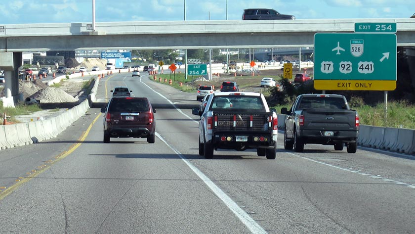
TPKE MM 255.3 N OF US-441/ SR-528
Camera Direction: NORTH. Source: FDOT - undetermined 32824
Cameras Closest To SR 528/Beach Line Expy / Orlando Intl/MCO
830 Ft
830 Ft
0.30 Mi
0.30 Mi
0.31 Mi
About this photo:
Florida's Turnpike SB at Exit 254, the Beachline Expressway (SR 528), in Orlando. Pic shows interchange reconstruction in progress. Photo taken November 7, 2019.
Photo taken 11-07-2019
The map above shows all services within about a two (2) mile radius.

Destination Travel

Closest Gas Stations
MOBIL
8911 South Orange Blossom Trail • 0.44 miles
Store/Fuel Brand: Mobil
SAM'S CLUB
9498 South Orange Blossom Trail • 0.55 miles
Store/Fuel Brand: Sam's Club
BP STATION
South Orange Blossom Trail • 0.66 miles
Store/Fuel Brand: BP
ACME TRUCK STOP
9565 South Orange Blossom Trail • 0.75 miles
Store/Fuel Brand:
Closest EV Chargers
FOUNTAIN MITSUBISHI
8701 South Orange Blossom Trail • 0.61 miles
CONNECTOR: IEC62196Type1
POWER: 7 KW @ 240 V
CURRENT: 30 Amp AC1
TRANSCORE ORLANDO
2416 Lake Orange Drive • 0.84 miles
CONNECTOR: IEC62196Type1
POWER: 7 KW @ 240 V
CURRENT: 30 Amp AC1
CHARGEPOINT
9750 South Orange Blossom Trail • 1.08 miles
CONNECTOR: IEC62196Type1
POWER: 6 KW @ 240 V
CURRENT: 27 Amp AC1
CHARGEPOINT
9786 South Orange Blossom Trail • 1.08 miles
CONNECTOR: IEC62196Type1
POWER: 6 KW @ 240 V
CURRENT: 27 Amp AC1

Closest Fast Food
Fast food refers ONLY to quick-service and take-out diners. All restaurant types are shown on the map above.
TACO BELL
9430 South Orange Blossom Trail • 0.46 miles
CHAAT HOUSE
9472 South Orange Blossom Trail • 0.47 miles
MCDONALD'S
8475 South Orange Blossom Trail • 0.78 miles
MCDONALD'S
8475 South Orange Blossom Trail • 0.78 miles
WENDY'S
2001 Principal Row • 1,342 feet
EL AREPAZO CRIOLLO
9789 South Orange Blossom Trail • 1.15 miles
CHICK-FIL-A
1500 Sand Lake Rd • 1.16 miles
CHURROMANIA
8001 South Orange Blossom Trail • 1.17 miles
Journey to key destinations around and adjacent to Florida!
Communities in this metro area include Destin, Pensacola Beach, Pensacola, Niceville, and Gulf Breeze.
Individual toll maps for this region are listed below.

Communities in this metro area include Jacksonville and Middleburg.
Individual toll maps for this region are listed below.

Communities in this metro area include Apopka, Cocoa, Kissimmee, Lake Buena Vista, Orlando, Saint Cloud, Sanford, Titusville, Melbourne, Poinciana, and Mount Dora.
Individual toll maps for this region are listed below.
Communities in this metro area include Bradenton, Brandon, Saint Petersburg, Spring Hill, and Tampa.
Individual toll maps for this region are listed below.
Communities in this metro area include Fort Pierce, Port Saint Lucie, Stuart, and Vero Beach.
Individual toll maps for this region are listed below.

Communities in this metro area include Fort Lauderdale, Pompano Beach, Hialeah, Opa Locka, Homestead, Kendall, Key Largo, Miramar, Miami, Hollywood, Sunrise, Boca Raton, Delray Beach, West Palm Beach, Jupiter, Davie, Coral Springs, Lake Worth, and Boynton Beach.
Individual toll maps for this region are listed below.
Communities in this metro area include Fort Myers, Naples, and Cape Coral.
Individual toll maps for this region are listed below.
Communities in this metro area include Mobile, Daphne, Dauphin Island, Chickasaw, and Spanish Fort.
Individual toll maps for this region are listed below.

Roads Within Region
 Garcon Point Bridge ▹
 Bob Sikes Bridge ▹
 SR 293 ▹
 First Coast Expressway ▹
 Central Florida Greeneway/Seminole Expy ▹
 Florida's Turnpike ▹
 East West Expressway ▹
 Beachline Expressway ▹
 Western Beltway/Wekiva Pkwy ▹
 Apopka Expressway ▹
 Poinciana Parkway ▹
 SR 453 ▹
 Goldenrod Road Extension ▹
 Osceola Parkway ▹
 SR 451 ▹
 Polk Parkway ▹
 Selmon Expressway ▹
 Suncoast Parkway/Veterans Expy ▹
 Sunshine Skyway ▹
 Pinellas Bayway ▹
 Gateway Expressway ▹
 Airport Expressway ▹
 Alligator Alley ▹
 Dolphin Expressway ▹
 Don Shula Expressway ▹
 Gratigny Parkway ▹
 Sawgrass Expressway ▹
 Snapper Creek Expressway ▹
 Rickenbacker Causeway ▹
 Venetian Causeway ▹
 Card Sound Road ▹
 Sanibel Causeway ▹
 Midpoint Memorial Bridge ▹
 Cape Coral Bridge ▹


