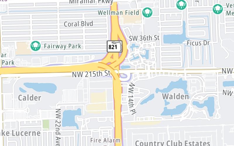
This is Exit 4X of Florida's Turnpike.
This junction is located in Miramar. Hollywood is nearby.
This location is in the Miami - South Florida area.
This location's approximate GPS Coordinates are 25.97212 x -80.22957.
Which directions can I travel from here?
From this junction, traffic can only enter going northbound.
The next exit is Hollywood Blvd/Pines Blvd, approximately 2.1 miles away ►
Which direction are tolls charged here?
The interactive map and lists on this page include key traveler services within two miles of this destination point.
You will find common services, including gas stations, truck stops, EV charging facilities, fast-food or family restaurants, and hotels. These are displayed on the interactive map as markers, which you can select for more information.
Current driving conditions and weather, along with a more complete list of key services, may be found below the map.
A summary of the closest services around Florida's Turnpike and NW 215th St/County Line Rd is shown below. More complete detail follows the map.
Pan and zoom the map as you desire, and select markers for information and other options, including online ordering, where available.
Cloudy
73°F / 23°C
Feels Like:
75°F / 24°C
Visibility
10 Mi / 16.1 Km
3-Hour Precip:
0 In / 0.0 Cm
North Northwest
Winds (NNW)
5.6 MPH / 9 KPH
Gusts:
12.4 MPH / 19.9 KPH
▸ Get the full forecast for This Location | The Miami - South Florida area
Closest Gas Stations
SUNSHINE SHELL
6924 Miramar Parkway • 0.69 miles
Store/Fuel Brand: Shell
MOBIL
7990 Riviera Boulevard • 1.03 miles
Store/Fuel Brand: Mobil
CHEVRON
20780 Northwest 27th Avenue • 1.19 miles
Store/Fuel Brand: Chevron
KWIK STOP
7955 Miramar Parkway • 1.24 miles
Store/Fuel Brand:
Closest EV Chargers
SHIRLEY BRANCA PARK
6900 Miramar Parkway • 0.62 miles
CONNECTOR: IEC62196Type1
POWER: 6 KW @ 240 V
CURRENT: 27 Amp AC1
CHARGEPOINT
6900 Miramar Parkway • 0.72 miles
CONNECTOR: IEC62196Type1
POWER: 6 KW @ 240 V
CURRENT: 27 Amp AC1
SHIRLEY BRANCA PARK
6900 Miramar Parkway • 0.72 miles
CONNECTOR: IEC62196Type1
POWER: 6 KW @ 240 V
CURRENT: 27 Amp AC1
Closest Fast Food
Fast food refers ONLY to quick-service and take-out diners. All restaurant types are shown on the map below.
GOOD TIMES
3813 Southwest 67th Terrace • 0.64 miles
TACO BELL
6961 Miramar Parkway • 0.73 miles
WENDY'S
3750 Utopia Drive • 1.05 miles
TACO BELL
3650 Utopia Drive • 1.06 miles
KFC
3650 Utopia Drive • 1.06 miles
LITTLE CAESARS
3358 South University Drive • 1.20 miles
MCDONALD'S
3306 South University Drive • 1.23 miles
MCDONALD'S
6204 Miramar Parkway • 1.42 miles
Hotels closest to NW 215th St/County Line Rd.
Select/Tap Vendors For Info
Vendors within about two miles of NW 215th St/County Line Rd and Florida's Turnpike are listed, sorted by distance, with the closest displayed on top. Select/tap the vendor name to show address, phone numbers and available URLs for gas stations, EV charging stations and fast-food dining. Links will open in a new window. Turnpikes.com is not responsible for third-party website content.
SUNSHINE SHELL
• 0.69 miles
MOBIL
• 1.03 miles
CHEVRON
• 1.19 miles
KWIK STOP
• 1.24 miles
RACEWAY
• 1.24 miles
MARATHON
• 1.25 miles
CHEVRON
• 1.28 miles
MOBIL
• 1.43 miles
SUNOCO
• 1.45 miles
MOBIL
• 1.51 miles
PINES GAS
• 1.57 miles
TWIN OIL COMPANY
• 1.58 miles
SUPER STOP
• 1.59 miles
KWIK SHOP
• 1.59 miles
MARATHON
• 1.60 miles
SPEEDWAY
• 1.60 miles
PEMBROKE U GAS
• 1.61 miles
SHELL
• 1.65 miles
SHIRLEY BRANCA PARK
• 0.62 miles
CHARGEPOINT
• 0.72 miles
SHIRLEY BRANCA PARK
• 0.72 miles
This list only includes quick-service and take-out restaurants. All nearby restaurants are shown on the map above.
GOOD TIMES
• 0.64 miles
TACO BELL
• 0.73 miles
WENDY'S
• 1.05 miles
TACO BELL
• 1.06 miles
KFC
• 1.06 miles
LITTLE CAESARS
• 1.20 miles
MCDONALD'S
• 1.23 miles
MCDONALD'S
• 1.42 miles
HUNGRY HOWIES
• 1.49 miles
SONIC
• 1.51 miles
POPEYES
• 1.52 miles
WINGSTOP
• 1.53 miles
DUNKIN'
• 1.54 miles
KFC
• 1.56 miles
MCDONALD'S
• 1.59 miles
PAPA JOHN'S
• 1.60 miles
POLLO TROPICAL
• 1.68 miles
GOLDEN KRUST CARIBBEAN BAKERY & GRILL GOLDEN KRUST
• 1.68 miles
KFC
• 1.69 miles
Journey to key destinations around and adjacent to Florida!
Communities in this metro area include Destin, Pensacola Beach, Pensacola, Niceville, and Gulf Breeze.
Individual toll maps for this region are listed below.
Communities in this metro area include Jacksonville and Middleburg.
Individual toll maps for this region are listed below.
Communities in this metro area include Apopka, Cocoa, Kissimmee, Lake Buena Vista, Orlando, Saint Cloud, Sanford, Titusville, Melbourne, Poinciana, and Mount Dora.
Individual toll maps for this region are listed below.
Communities in this metro area include Bradenton, Brandon, Saint Petersburg, Spring Hill, and Tampa.
Individual toll maps for this region are listed below.
Communities in this metro area include Fort Pierce, Port Saint Lucie, Stuart, and Vero Beach.
Individual toll maps for this region are listed below.
Communities in this metro area include Fort Lauderdale, Pompano Beach, Hialeah, Opa Locka, Homestead, Kendall, Key Largo, Miramar, Miami, Hollywood, Sunrise, Boca Raton, Delray Beach, West Palm Beach, Jupiter, Davie, Coral Springs, Lake Worth, and Boynton Beach.
Individual toll maps for this region are listed below.
Communities in this metro area include Fort Myers, Naples, and Cape Coral.
Individual toll maps for this region are listed below.
Communities in this metro area include Mobile, Daphne, Dauphin Island, Chickasaw, and Spanish Fort.
Individual toll maps for this region are listed below.
Roads Within Region